
Towns & cities · Yorkshire & the Humber
Malham
Malham — village and civil parish in North Yorkshire, England, UK.

Wikimedia Commons contributors — see linked file page for photographer and licence licence

Plan your visit
- Typical visit
- 3 h–6 h
- Nearest railway station
- Hellifield · 7.4 km
- Free entry
- Family-friendly
- Dog-friendly
Getting there & planning your visit
To visit Malham, the nearest railway station is Hellifield, located 7.4 km away. Entry to the town is free.
About
Malham is a town, city, village or settlement in the United Kingdom. Recent population estimates put it at around 162 people. Address: BD23. Wikidata describes it as: "village and civil parish in North Yorkshire, England, UK". Coordinates: 54.0610°, -2.1530°.
Photo gallery
See it from the streetimagery from 2022
Imagery © Mapillary contributors, CC BY-SA 4.0
Official information
Malham is a picturesque village located in the Yorkshire Dales, known for its stunning natural attractions such as Malham Cove and Gordale Scar. Visitors can enjoy scenic walks and explore the area's rich history, including remnants from the Iron Age.
Protected designations
- Site of Special Scientific Interest: Malham-Arncliffe SSSI
Designations sourced from Natural England open data under OGL v3.
From the Wikipedia article
Malham is a village and civil parish in the county of North Yorkshire, England. In the Domesday Book, the name is given as Malgun, meaning "settlement by the gravelly places". Until 1974 it was part of the Settle Rural District, in the historic West Riding of Yorkshire. From 1974 to 2023 it was part of the Craven District, it is now administered by the unitary North Yorkshire Council. In 2001 the parish had a population of approximately 150. Malham parish increased in size geographically (to include Malham Moor) and so at the 2011 Census had a population of 238. Malham lies at the upper end of the valley of the River Aire, known above Airton as Malhamdale, in the Yorkshire Dales. The surrounding countryside is well known for its limestone pavements and other examples of limestone scenery. Tourist attractions include Malham Tarn, Malham Cove, Gordale Scar, Janet's Foss and the Dry Valley. In the 1950s the village gave its name to a Ham class minesweeper, HMS Malham.
Excerpt from Wikipedia under CC BY-SA 4.0. See the source article linked in Sources below.
Background
Visiting
Malham is a popular walkers' destination. The rise in tourism over Malham's history has led to some deterioration of the area's surrounding paths as tourists wander off the paths and cause pockets of erosion, a process often called "footpath erosion". The footpaths in the area are maintained by the Yorkshire Dales National Park Authority. In the village there is a National Park Information Centre and a large car park. The Pennine Way long-distance path passes through the village. Nearby natural landmarks include Malham Cove, Malham Tarn, Gordale Scar and Janet's Foss. The Malham Show Fell Race course runs over the nearby 301 m Cawden. In May 2006, it was reported that a covert listening…
Sourced from Wikipedia under CC BY-SA 4.0.
- Coordinates
- 54.0610, -2.1530
- District
- North Yorkshire
- Parish
- Malham
- Postcode
- BD23
- Parliamentary constituency
- Skipton and Ripon
- Population
- 162
- Nearest railway station
- Hellifield — 7.4 km
- Official site
- www.malhamdale.com
Sources
- wikidata: Q1247558 (CC0)
- wikipedia: Malham (CC BY-SA 4.0)
- commons: Lister Arms, Malham - geograph.org.uk - 559747.jpg (CC BY-SA 4.0)
Other places nearby

Walter Morrison
Memorials & monuments · 0.0 km

New Bridge, Malham
Historic bridges · 0.1 km

The Lister Arms Hotel
Hotels · 0.1 km

Youth Hostel Association Malham
Hostels · 0.2 km

Hill Top Farm Bunk Barn
Hostels · 0.3 km

Friar Garth Farmhouse
Farms (open to visitors) · 0.3 km

Town Head Barn
Natural landmarks · 0.5 km

Riverside Campsite
Campsites · 0.5 km

Cowden
Mountains & hills · 0.6 km

Malham Mill
Archaeological sites · 0.6 km

Field Barns
Archaeological sites · 0.8 km

Yarnthawe Barn
Historic houses · 0.9 km
Malham is a charming town in Yorkshire, offering visitors a chance to explore its stunning natural landscapes. You can enjoy breathtaking views at Janet's Foss and Gordale Scar, or discover the geological wonders of Malham Cove and its associated cave.
At a glance
- Population
- 162
- Constituency
- Skipton and Ripon
- Top categories near here
Things to see in Malham
52 attractions within 12 km — showing the 24 most editorially-significant. Full guide: things to do in Malham →
 📷 3
📷 3Forests & woodlands · Yorkshire & the Humber
Globe Flower Wood
Globe Flower Wood is a forest or woodland in the United Kingdom.
 📷 5
📷 5Viewpoints · Yorkshire & the Humber
Gordale Scar
Gordale Scar is a viewpoint in the United Kingdom.
 📷 5
📷 5Viewpoints · Yorkshire & the Humber
Janet's Foss
Janet's Foss is a viewpoint in the United Kingdom.
 📷 3
📷 3Caves · Yorkshire & the Humber
Pikedaw Calamine Caverns
Pikedaw Calamine Caverns is a cave in the United Kingdom.
 📷 5
📷 5Historic churches · Yorkshire & the Humber
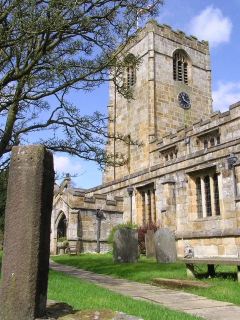
St Michael's Church, Kirkby Malham
St Michael's Church, Kirkby Malham — church in Kirkby Malham, North Yorkshire, England, UK.
 📷 5
📷 5National parks · Yorkshire & the Humber
Malham Cove
Malham Cove is a large curved limestone formation 0.6 miles (1 km) north of the village of Malham, North Yorkshire, England. It was formed by a waterfall carrying meltwater from glaciers at the end of
📷 3Natural landmarks · Yorkshire & the Humber
Town Head Barn
Town Head Barn — a place in Yorkshire & the Humber, United Kingdom.
 📷 3
📷 3Archaeological sites · Yorkshire & the Humber
Ling Top Lathe
Ling Top Lathe — an archaeological site in Yorkshire & the Humber, United Kingdom.
📷 3Archaeological sites · Yorkshire & the Humber
Malham Mill
Malham Mill — an archaeological site in Yorkshire & the Humber, United Kingdom.
 📷 3
📷 3Archaeological sites · Yorkshire & the Humber
Kirk Gill House
Kirk Gill House — an archaeological site in Yorkshire & the Humber, United Kingdom.
 📷 3
📷 3Archaeological sites · Yorkshire & the Humber
Sell Gill Barn
Sell Gill Barn — an archaeological site in Yorkshire & the Humber, United Kingdom.
 📷 3
📷 3Archaeological sites · Yorkshire & the Humber
Crossdale Barn
Crossdale Barn — an archaeological site in Yorkshire & the Humber, United Kingdom.
 📷 3
📷 3Archaeological sites · Yorkshire & the Humber
Ray Barn
Ray Barn — an archaeological site in Yorkshire & the Humber, United Kingdom.
 📷 3
📷 3Archaeological sites · Yorkshire & the Humber
Bare Gill
Bare Gill — an archaeological site in Yorkshire & the Humber, United Kingdom.
 📷 5
📷 5Archaeological sites · Yorkshire & the Humber
Fish Lathe
Fish Lathe — an archaeological site in Yorkshire & the Humber, United Kingdom.
 📷 3
📷 3Archaeological sites · Yorkshire & the Humber
old quarry workings
old quarry workings — an archaeological site in Yorkshire & the Humber, United Kingdom.
 📷 3
📷 3Archaeological sites · Yorkshire & the Humber
Mastiles Lane marching camp
Mastiles Lane marching camp — an archaeological site in Yorkshire & the Humber, United Kingdom.
 📷 3
📷 3Archaeological sites · Yorkshire & the Humber
old gravel pit
old gravel pit — an archaeological site in Yorkshire & the Humber, United Kingdom.
📷 3Archaeological sites · Yorkshire & the Humber
Field Barns
Field Barns — an archaeological site in Yorkshire & the Humber, United Kingdom.
📷 3Historic houses · Yorkshire & the Humber
Yarnthawe Barn
Yarnthawe Barn — a historic house in Yorkshire & the Humber, United Kingdom.
 📷 3
📷 3Historic houses · Yorkshire & the Humber
Stone Bank Lathe
Stone Bank Lathe — a historic house in Yorkshire & the Humber, United Kingdom.
 📷 3
📷 3Historic houses · Yorkshire & the Humber
Bombey's Barn
Bombey's Barn — a historic house in Yorkshire & the Humber, United Kingdom.
📷 3Historic houses · Yorkshire & the Humber
Out Gang Barn
Out Gang Barn — a historic house in Yorkshire & the Humber, United Kingdom.
 📷 3
📷 3Historic houses · Yorkshire & the Humber
East Field Lathe
East Field Lathe — a historic house in Yorkshire & the Humber, United Kingdom.
Nearby
📷 3Memorials & monuments · Yorkshire & the Humber
Walter Morrison
Walter Morrison — a memorial in Yorkshire & the Humber, United Kingdom.
📷 3Historic bridges · Yorkshire & the Humber
New Bridge, Malham
New Bridge, Malham — Grade II listed building-listed bridge in england-north-west, United Kingdom.
📷 7Hotels · Yorkshire & the Humber
The Lister Arms Hotel
The Lister Arms Hotel — a hotel in england north west.
📷 5Hostels · Yorkshire & the Humber
Youth Hostel Association Malham
Youth Hostel Association Malham — a hostel in england north west.
📷 5Hostels · Yorkshire & the Humber
Hill Top Farm Bunk Barn
Hill Top Farm Bunk Barn — a hostel in england north west.
📷 4Farms (open to visitors) · Yorkshire & the Humber
Friar Garth Farmhouse
Friar Garth Farmhouse — a Grade II-listed farm in england-north-west, United Kingdom.
Where to eat & stay near Malham
Places to stay
📷 7Hotels · Yorkshire & the Humber
The Lister Arms Hotel
The Lister Arms Hotel — a hotel in england north west.
📷 5Hostels · Yorkshire & the Humber
Youth Hostel Association Malham
Youth Hostel Association Malham — a hostel in england north west.
📷 5Hostels · Yorkshire & the Humber
Hill Top Farm Bunk Barn
Hill Top Farm Bunk Barn — a hostel in england north west.
📷 5Campsites · Yorkshire & the Humber
Riverside Campsite
Riverside Campsite — a campsite in england north west.
 📷 5
📷 5Campsites · Yorkshire & the Humber
Gordale Scar Campsite
Gordale Scar Campsite — a campsite in england north west.
 📷 5
📷 5Caravan parks · Yorkshire & the Humber
Hurries Farm CL
Hurries Farm CL — a caravan park in england north west.
Places to eat & drink
 📷 5
📷 5Restaurants · Yorkshire & the Humber
The Angel Inn
The Angel Inn — a restaurant in england north west.
 📷 7
📷 7 📷 6
📷 6Historic pubs · North West England
Falcon Manor Hotel
Falcon Manor Hotel in England North West, United Kingdom.
 📷 7
📷 7Cafés · Yorkshire & the Humber
The Dalesman Cafe, Tea Room and Sweet Emporium
The Dalesman Cafe, Tea Room and Sweet Emporium — a café in england north west.
 📷 5
📷 5Historic pubs · Yorkshire & the Humber
Grassington House Hotel
Grassington House Hotel in England Yorkshire, United Kingdom.
 📷 5
📷 5Historic pubs · North West England
Crow Trees Inn
Crow Trees Inn in England North West, United Kingdom.
More towns in this region
 Flagship📷 3
Towns & cities · Yorkshire & the Humber
Hazel Grove
Hazel Grove — suburb within the Metropolitan Borough of Stockport, in Greater Manchester, England.
 Flagship📷 3
Towns & cities · Yorkshire & the Humber
High Lane
High Lane — village in the Metropolitan Borough of Stockport, Greater Manchester, United Kingdom.
 📷 5
📷 5Towns & cities · Yorkshire & the Humber
Disley
Disley — village in Cheshire East, Cheshire, England, UK.
 📷 3
📷 3Frequently asked questions
- Where is Malham?
- Malham is in Yorkshire, United Kingdom (postcode BD23), in the parish of Malham.
- What is Malham?
- Malham — village and civil parish in North Yorkshire, England, UK.
- How do I get to Malham?
- The nearest railway station is Hellifield, about 7.4 km away. Drivers can use postcode BD23.
- Is Malham a protected site?
- Yes — Malham is part of the Malham-Arncliffe SSSI Site of Special Scientific Interest.
- Is Malham free to visit?
- Yes, Malham is free to enter.
- How do I get to Malham?
- The nearest railway station is Hellifield, about 7.4 km away. Drivers can navigate to postcode BD23.