Reservoirs & lochs · Scottish Highlands
Loch Meig
In or near Strathpeffer.
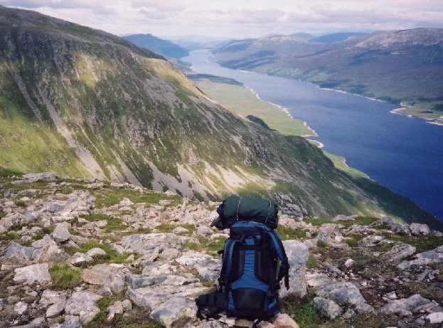
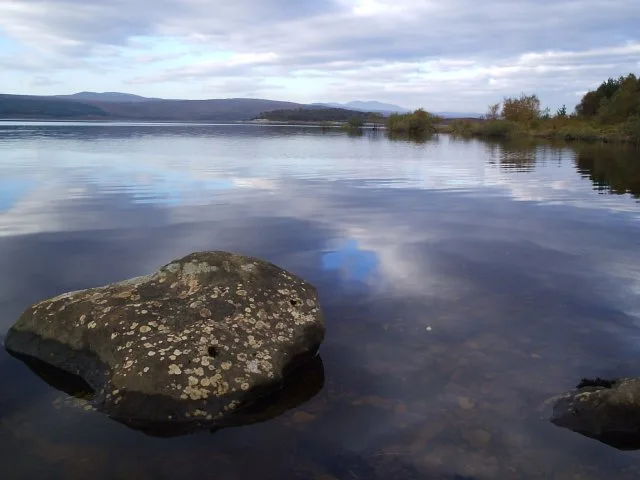
Loch Meig — reservoir in Contin, Highland, Scotland, UK, on River Meig.

Wikimedia Commons contributors — see linked file page for photographer and licence licence
Plan your visit
- Typical visit
- 1 h–2.5 h
- Nearest railway station
- Garve · 6.4 km
- Free entry
- Dog-friendly
Getting there & planning your visit
Loch Meig is located in the Scottish Highlands, with the nearest railway station being Garve, which is 6.4 km away. Entry to the reservoir is free.
About
Loch Meig is a reservoir in the United Kingdom. Wikidata describes it as: "reservoir in Contin, Highland, Scotland, UK, on River Meig". Coordinates: 57.5626°, -4.7397°.
Photo gallery
From the Wikipedia article
Loch Meig (Scottish Gaelic: Loch Mìg) is a freshwater loch in Easter Ross, Scotland, 8.1 kilometres (5.0 mi) west of Contin. Situated on the River Meig, the loch is a manmade reservoir formed from the construction of the Meig Dam in 1957. This was part of a series of post-war infrastructure projects led by the North of Scotland Hydro-Electric Board (NoSHEB). The reservoir is part of the Conon Hydro Scheme. Loch Meig has large brown trout and perch populations, making it a popular choice for fly fishers. The local angling club has helped to boost trout stocks by introducing several hundred fish a year. The fishing season runs from 1 April to 30 September. Today, the loch is mostly surrounded by timber plantations. However, several sites of historic interest sit on its north and south shores, including ruined farmsteads and sheepdips. The building of the Meig Dam caused many ruins to disappear underwater. The name of the loch and its parent river derives from an Old Gaelic root, minc, with cognates in Latin, Old Welsh, and Old English. It roughly translates to "pouring forth". Alongside Loch Achonachie and Loch Garve, Loch Meig was the site of a 2018 combined SEPA/University of Glasgow study on the behaviour and movement of salmon smolts through impounded lakes.
Excerpt from Wikipedia under CC BY-SA 4.0. See the source article linked in Sources below.
- Coordinates
- 57.5626, -4.7397
- Address
- Easter Ross, Scotland
- Nearest railway station
- Garve — 6.4 km
Sources
- wikidata: Q124289858 (CC0)
- wikipedia: Loch Meig (CC BY-SA 4.0)
- commons: Loch Meig - geograph.org.uk - 3620818.jpg (CC BY-SA 4.0)
Other places nearby

Strath Conon
Gorges · 1.5 km

Torr a' Bhealaidh
Mountains & hills · 1.6 km

Glenmarksie
Gorges · 2.4 km

Carn na Cloiche Moire
Mountains & hills · 2.8 km

Great North Trail (Northern Highlands)
Mountain bike trails · 2.9 km

Creag Loch nan Dearcag
Mountains & hills · 3.0 km
Creag Loch nan Dearcag
Mountains & hills · 3.0 km
Falls of Conon
Waterfalls · 3.1 km

Glenmarskie
Vineyards · 3.1 km

Falls of Conon
Waterfalls · 3.4 km

River Meig
Reservoirs & lochs · 3.5 km

Sgurr Marcasaidh
Mountains & hills · 3.6 km
Nearby
📷 5📷 5Mountains & hills · Scottish Highlands
Torr a' Bhealaidh
Torr a' Bhealaidh — mountain in scotland highlands. Elevation: 338 m.
📷 5📷 5Mountains & hills · Scottish Highlands
Carn na Cloiche Moire
Carn na Cloiche Moire — a hill or mountain in scotland highlands.
📷 2Mountain bike trails · Scottish Highlands
Great North Trail (Northern Highlands)
Great North Trail (Northern Highlands) — a mtb trail in scotland highlands.
📷 3Mountains & hills · Scottish Highlands
Creag Loch nan Dearcag
Creag Loch nan Dearcag — mountain in scotland highlands. Elevation: 537 m.
Where to eat & stay near Loch Meig
Places to stay
 📷 5
📷 5Campsites · Scottish Highlands
Riverside Campsite
Riverside Campsite — a campsite in scotland highlands.
 📷 5
📷 5Hostels · Scottish Highlands
Fairburn Activity Centre
Fairburn Activity Centre — a hostel in scotland highlands.
 📷 5
📷 5B&Bs · Scottish Highlands
Holly Lodge
Holly Lodge — a bed-and-breakfast in scotland highlands.
 📷 7
📷 7Hotels · Scottish Highlands
The Cnoc Hotel
The Cnoc Hotel — a hotel in scotland highlands.
 📷 5
📷 5 📷 7
📷 7Places to eat & drink
📷 5Historic pubs · Scottish Highlands
Holly Lodge Hotel, Strathpeffer
Holly Lodge Hotel, Strathpeffer in Scotland Highlands, United Kingdom.
More places in this region
 Flagship📷 3
Reservoirs & lochs · Scottish Highlands
Loch Ericht
Loch Ericht — lake in Perth and Kinross, and Highland, Scotland, UK, outflows to River Ericht.
 Flagship📷 3
Reservoirs & lochs · Scottish Highlands
Loch Shin
Loch Shin — reservoir in Highland, Scotland, UK, outflows to the River Shin.
 📷 4
📷 4Reservoirs & lochs · Scottish Highlands
Backwater Reservoir
Backwater Reservoir — lake in Angus, Scotland, UK.
 📷 3
📷 3Reservoirs & lochs · Scottish Highlands
Blackwater Reservoir
Blackwater Reservoir — reservoir in Highland, Scotland, UK, outflows to the River Leven.
Frequently asked questions
- Where is Loch Meig?
- Loch Meig is in the Scottish Highlands, United Kingdom.
- What is Loch Meig?
- Loch Meig — reservoir in Contin, Highland, Scotland, UK, on River Meig.
- How do I get to Loch Meig?
- The nearest railway station is Garve, about 6.4 km away. Its coordinates are 57.5626°, -4.7397°.
- Is Loch Meig free to visit?
- Yes, Loch Meig is free to enter.
- How do I get to Loch Meig?
- The nearest railway station is Garve, about 6.4 km away.