Natural landmarks · Scottish Lowlands
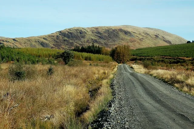
Kirriereoch Hill
Kirriereoch Hill — 786m high mountain in Scotland.

Wikimedia Commons contributors — see linked file page for photographer and licence licence
Plan your visit
- Typical visit
- 1 h–2 h
- Free entry
- Dog-friendly
About
Kirriereoch Hill is a named natural landmark in the United Kingdom. Wikidata describes it as: "786m high mountain in Scotland". Coordinates: 55.1516°, -4.4796°.
Photo gallery
From the Wikipedia article
Kirriereoch Hill is a hill in the Range of the Awful Hand, a sub-range of the Galloway Hills range, part of the Southern Uplands of Scotland. It lies on the border of the old counties of Ayrshire and Kirkcudbrightshire, or the modern regions of Dumfries and Galloway and South Ayrshire. A boundary wall near the summit is the highest point in South Ayrshire and Ayrshire as a whole. Kirriereoch Hill was classified as a Corbett and Marilyn but then deleted from these lists in 1984 due to not being thought to achieve the respective prominence criteria. In August 2015 the hill was relisted as a Marilyn after having been surveyed to have a 150.2 m prominence. However, since this is less than the 152.4 m required, the hill will not be re-listed as a Corbett. Its current name derives from Kirriereoch farm to its west, as hill in Scots can mean a hillside grazing ground but it was originally recorded in 1654 as "Meal Tuaichtan", a corruption of the original Gaelic name Meall an t-Suachdain. This name was kept for the loch beside the summit, Loch Twachtan (Loch an t-Suachdain).
Excerpt from Wikipedia under CC BY-SA 4.0. See the source article linked in Sources below.
- Coordinates
- 55.1516, -4.4796
- Address
- South Ayrshire, Dumfries and Galloway, Scotland
Sources
- wikidata: Q6416012 (CC0)
- wikipedia: Kirriereoch Hill (CC BY-SA 4.0)
- commons: Along The Track - geograph.org.uk - 1540312.jpg (CC BY-SA 4.0)
Other places nearby
Kirriereoch Hill
Mountains & hills · 0.1 km
Merrick
Mountains & hills · 1.5 km

Merrick
Natural landmarks · 1.6 km

Castle on Oyne
Mountains & hills · 1.8 km

Tarfessock
Mountains & hills · 2.5 km
Benyellary
Mountains & hills · 3.1 km

Benyellary
Natural landmarks · 3.1 km

Loch Enoch
Natural landmarks · 3.1 km

Kirriemore Hill
Mountains & hills · 3.1 km
Mullwharchar
Mountains & hills · 3.3 km

Macaterick
Mountains & hills · 3.4 km

Hoodens Hill
Mountains & hills · 3.5 km
Nearby
📷 3📷 5📷 5Natural landmarks · Scottish Lowlands
Merrick
Merrick — 843m high mountain in Dumfries and Galloway, Scotland, UK.
📷 5Mountains & hills · Scottish Lowlands
Castle on Oyne
Castle on Oyne — mountain in scotland lowlands. Elevation: 466 m.
📷 4Mountains & hills · Scottish Lowlands
Tarfessock
Tarfessock — a mountain in scotland-lowlands, United Kingdom.
📷 3Where to eat & stay near Kirriereoch Hill
Places to stay
 📷 5
📷 5Campsites · Scottish Lowlands
Glentrool Camping & Caravan Site
Glentrool Camping & Caravan Site — a campsite in scotland lowlands.
 📷 5
📷 5Caravan parks · Scottish Lowlands
Loch Doon Caravan Park
Loch Doon Caravan Park — a caravan park in scotland lowlands.
 📷 5
📷 5Caravan parks · Scottish Lowlands
Barrhill Holiday Park
Barrhill Holiday Park — a caravan park in scotland lowlands.
 📷 5
📷 5Hostels · North West England
Minigaff Youth Hostel
Minigaff Youth Hostel — a hostel in scotland lowlands.
 📷 7
📷 7Hotels · North West England
Cree Bridge House Hotel
Cree Bridge House Hotel — a hotel in scotland lowlands.
 📷 5
📷 5Campsites · North West England
Creebridge Caravan Park
Creebridge Caravan Park — a campsite in scotland lowlands.
Places to eat & drink
 📷 5
📷 5Historic pubs · Scottish Lowlands
Doon Tavern, High Street, Dalmellington
Doon Tavern, High Street, Dalmellington in Scotland Lowlands, United Kingdom.
 📷 5
📷 5Historic pubs · Scottish Lowlands
The White House and Adjoining Joiner's Shop, Kirkmichael Arms, Straiton Road, Kirkmichael
The White House and Adjoining Joiner's Shop, Kirkmichael Arms, Straiton Road, Kirkmichael in Scotland Lowlands, United Kingdom.
More natural landmarks in this region
 📷 5
📷 5Natural landmarks · Scottish Lowlands
Birkenside
Birkenside in England North East, United Kingdom.
 📷 4
📷 4Natural landmarks · Scottish Lowlands
River Teviot
River Teviot in England North East, United Kingdom.
 📷 5
📷 5Natural landmarks · Scottish Lowlands
River Leader
River Leader in England North East, United Kingdom.
 📷 4
📷 4Natural landmarks · Scottish Lowlands
Makerstoun
Makerstoun in England North East, United Kingdom.
Frequently asked questions
- Where is Kirriereoch Hill?
- Kirriereoch Hill is in the Scottish Lowlands, United Kingdom.
- What is Kirriereoch Hill?
- Kirriereoch Hill — 786m high mountain in Scotland.
- How do I get to Kirriereoch Hill?
- Its coordinates are 55.1516°, -4.4796°.
- Is Kirriereoch Hill free to visit?
- Yes, Kirriereoch Hill is free to enter.