Natural landmarks · Scottish Lowlands
Benyellary
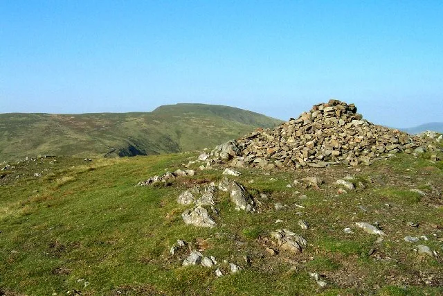
Benyellary — mountain in Dumfries and Galloway, Scotland, UK.

Wikimedia Commons contributors — see linked file page for photographer and licence licence
Plan your visit
- Typical visit
- 1 h–2 h
- Free entry
- Dog-friendly
About
Benyellary is a named natural landmark in the United Kingdom. Wikidata describes it as: "mountain in Dumfries and Galloway, Scotland, UK". Coordinates: 55.1241°, -4.4874°.
Photo gallery
Place summary
Benyellary is a natural landmark located in the Scottish Lowlands. It is notable for its distinctive geographical features, contributing to the region's diverse landscape.
AI-generated from the structured facts on this page (operator, designation, listing, era). Not a substitute for visiting.
- Coordinates
- 55.1241, -4.4874
Sources
- wikidata: Q4890738 (CC0)
- wikipedia: Benyellary (CC BY-SA 4.0)
- commons: Benyellary.jpg (CC BY-SA 4.0)
Other places nearby
Benyellary
Mountains & hills · 0.0 km

Bennan (Am Beinnean)
Mountains & hills · 1.3 km

Bill McDonald Memorial
Memorials & monuments · 1.8 km

Merrick
Natural landmarks · 2.1 km
Merrick
Mountains & hills · 2.1 km

Buchan Hill
Mountains & hills · 2.3 km
Buchan Hill
Mountains & hills · 2.4 km

Meaul
Mountains & hills · 2.5 km

Benmore (A' Bheinn Mhòr)
Mountains & hills · 2.8 km
Kirriereoch Hill
Natural landmarks · 3.1 km

Craig Neldricken
Mountains & hills · 3.1 km

Kirriereoch Hill
Mountains & hills · 3.1 km
Nearby
📷 3📷 5Mountains & hills · Scottish Lowlands
Bennan (Am Beinnean)
Bennan (Am Beinnean) — mountain in scotland lowlands. Elevation: 562 m.
📷 3Memorials & monuments · Scottish Lowlands
Bill McDonald Memorial
Bill McDonald Memorial — a memorial in scotland-lowlands, United Kingdom.
📷 5Natural landmarks · Scottish Lowlands
Merrick
Merrick — 843m high mountain in Dumfries and Galloway, Scotland, UK.
📷 5📷 5Mountains & hills · Scottish Lowlands
Buchan Hill
Buchan Hill — mountain in scotland lowlands. Elevation: 493 m.
Where to eat & stay near Benyellary
Places to stay
 📷 5
📷 5Campsites · Scottish Lowlands
Glentrool Camping & Caravan Site
Glentrool Camping & Caravan Site — a campsite in scotland lowlands.
 📷 5
📷 5Hostels · North West England
Minigaff Youth Hostel
Minigaff Youth Hostel — a hostel in scotland lowlands.
 📷 5
📷 5Caravan parks · Scottish Lowlands
Loch Doon Caravan Park
Loch Doon Caravan Park — a caravan park in scotland lowlands.
 📷 7
📷 7Hotels · North West England
Cree Bridge House Hotel
Cree Bridge House Hotel — a hotel in scotland lowlands.
 📷 5
📷 5Campsites · North West England
Creebridge Caravan Park
Creebridge Caravan Park — a campsite in scotland lowlands.
 📷 5
📷 5Caravan parks · Scottish Lowlands
Barrhill Holiday Park
Barrhill Holiday Park — a caravan park in scotland lowlands.
Places to eat & drink
 📷 5
📷 5Historic pubs · Scottish Lowlands
Doon Tavern, High Street, Dalmellington
Doon Tavern, High Street, Dalmellington in Scotland Lowlands, United Kingdom.
 📷 7
📷 7Historic pubs · North West England
The Craighlaw Arms, 23 Main Street, Kirkcowan
The Craighlaw Arms, 23 Main Street, Kirkcowan in Scotland Lowlands, United Kingdom.
More natural landmarks in this region
 📷 5
📷 5Natural landmarks · Scottish Lowlands
Birkenside
Birkenside in England North East, United Kingdom.
 📷 4
📷 4Natural landmarks · Scottish Lowlands
River Teviot
River Teviot in England North East, United Kingdom.
 📷 5
📷 5Natural landmarks · Scottish Lowlands
River Leader
River Leader in England North East, United Kingdom.
 📷 4
📷 4Natural landmarks · Scottish Lowlands
Makerstoun
Makerstoun in England North East, United Kingdom.
Frequently asked questions
- Where is Benyellary?
- Benyellary is in the Scottish Lowlands, United Kingdom.
- What is Benyellary?
- Benyellary — mountain in Dumfries and Galloway, Scotland, UK.
- How do I get to Benyellary?
- Its coordinates are 55.1241°, -4.4874°.
- Is Benyellary free to visit?
- Yes, Benyellary is free to enter.