
Mountains & hills · South West England
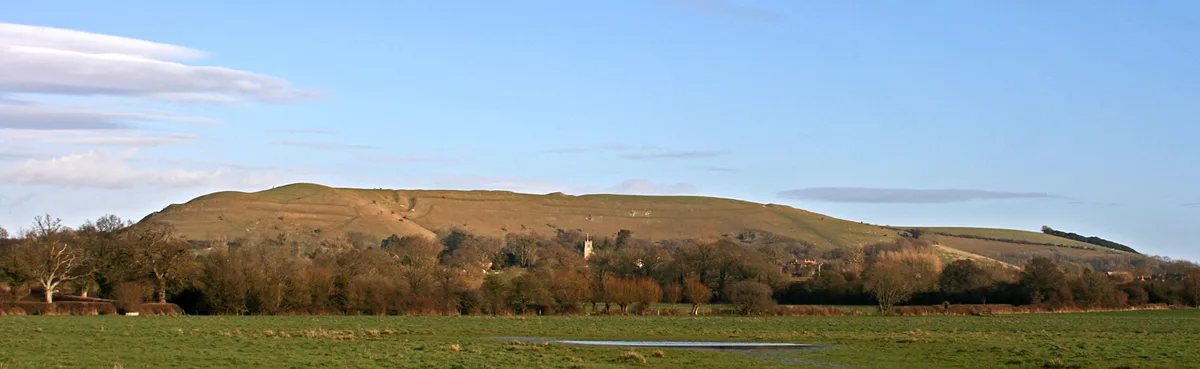
Hod Hill
In or near Stourpaine.
Hod Hill — Named summit at 144 m.

Wikimedia Commons contributors — see linked file page for photographer and licence licence

Plan your visit
- Typical visit
- 3 h–8 h
- Best time of year
- Late spring – early autumn (May–Oct)
- Free entry
- Dog-friendly
About
Hod Hill is a named summit in the United Kingdom. Wikidata describes it as: "Named summit at 144 m.". Coordinates: 50.8961°, -2.2071°.
Photo gallery
Official information
Hod Hill is an ancient hillfort located in Dorset, England. Visitors can explore the historical significance of the site, which features earthworks and offers scenic views of the surrounding landscape.
Protected designations
- Site of Special Scientific Interest: Hod and Hambledon Hills SSSI
- Area of Outstanding Natural Beauty: Dorset
- Area of Outstanding Natural Beauty: Cranborne Chase & West Wiltshire Downs
Designations sourced from Natural England open data under OGL v3.
From the Wikipedia article
Hod Hill (or Hodd Hill) is a large hill fort in the Blackmore Vale, 3 miles (5 km) north-west of Blandford Forum, Dorset, England. The fort sits on a 143 m (469 ft) chalk hill of the same name that lies between the adjacent Dorset Downs and Cranborne Chase. The hill fort at Hambledon Hill is just to the north. The name probably comes from Old English "hod", meaning a shelter, though "hod" could also mean "hood", referring to the shape of the hill. The fort is roughly rectangular (600 by 400 m (2,000 by 1,300 ft)), with an enclosed area of 22 ha (54 acres). There is a steep natural slope down to the River Stour to the west, the other sides have an artificial rampart, ditch and counterscarp (outer bank), with an additional rampart on the north side. The main entrance is at the south-east corner, with other openings at the south-west and north-east corners. The hillfort was inhabited by the Durotriges in the late Iron Age; whether this is the same tribe who fortified the hilltop in the middle Iron Age (radiocarbon analysis suggests a date of 500 BC for the main rampart) is unknown. There is extensive evidence of settlement within the fort, including platforms for roundhouses. Hod Hill is the second in a series of Iron Age earthworks, starting from Hambledon Hill, and including Hod Hill, Spetisbury Rings, Buzbury Rings, Badbury Rings and Dudsbury Camp. The Iron Age port at Hengistbury Head forms a final Iron Age monument in this small chain of sites. Although it is traditionally thought that the hill was captured in AD 43 by the Roman Second Legion (Augusta), led by Vespasian, who by then had already captured Maiden Castle and other hill forts to the south, this interpretation now seems unlikely. It is clear that the hillfort had long been abandoned by the time the Roman army arrived in Dorset, the many iron ballista bolts which have been found across the hill, clustered in the so-called "Chieftain's hut" area (two hut circles, one of which had an enclosure around it)…
Excerpt from Wikipedia under CC BY-SA 4.0. See the source article linked in Sources below.
- Coordinates
- 50.8961, -2.2071
- District
- Dorset
- Parish
- Hanford
- Postcode
- DT11 8PS
- Parliamentary constituency
- North Dorset
Sources
- osm: n524333760 (ODbL)
- wikipedia: Hod Hill (CC BY-SA 4.0)
- commons: Northern side of the hillfort on Hod Hill - geograph.org.uk - 242753.jpg (CC BY-SA 4.0)
Other places nearby

Hod Hill
Vineyards · 0.2 km

Stepleton House
Historic houses · 1.0 km

Ornamental bridge 250 m south west of Ranston
Historic bridges · 1.4 km

Stourpaine
Towns & cities · 1.6 km
Hambledon Hill
Mountains & hills · 1.9 km

Knighton Manor
Manor houses · 2.2 km

Hambledon Hill
Vineyards · 2.2 km

Durweston Bridge
Historic bridges · 2.3 km

Iwerne Courtney
Villages · 2.3 km

Durweston
Towns & cities · 2.4 km

Shillingstone
Villages · 2.7 km

Child Okeford
Villages · 2.9 km
Nearby
📷 5Vineyards · South West England
Hod Hill
Hod Hill — a UK vineyard in england south east, producing English or Welsh wine from cool-climate grape varieties.
📷 5Historic houses · South West England
Stepleton House
Stepleton House — Grade I listed house in North Dorset, England, UK.
📷 5Historic bridges · South West England
Ornamental bridge 250 m south west of Ranston
Ornamental bridge 250 m south west of Ranston — Grade II listed building-listed bridge in england-south-east, United Kingdom.
📷 5📷 5📷 5Manor houses · South West England
Knighton Manor
Knighton Manor — Grade II listed building-listed manor in england-south-east, United Kingdom.
Where to eat & stay near Hod Hill
Places to stay
 📷 5
📷 5Hotels · South West England
The Crown Hotel
The Crown Hotel — a hotel in england south east.
 📷 5
📷 5 📷 5
📷 5 📷 5
📷 5 📷 5
📷 5 📷 5
📷 5Places to eat & drink
 📷 7
📷 7Historic pubs · South West England
The Talbot at Iwerne Minster
The Talbot at Iwerne Minster in England South West, United Kingdom.
 📷 7
📷 7Restaurants · South West England
Three Kings
Three Kings — a restaurant in england south east.
 📷 7
📷 7Historic pubs · South West England
Fiddleford Inn
Fiddleford Inn in England South West, United Kingdom.
 📷 7
📷 7 📷 7
📷 7Historic pubs · South West England
The White Hart Hotel
The White Hart Hotel in England South West, United Kingdom.
 📷 5
📷 5Historic pubs · South West England
The Hambro Arms Inn
The Hambro Arms Inn in England South West, United Kingdom.
More mountains in this region
 📷 5
📷 5 📷 5
📷 5 📷 5
📷 5 📷 5
📷 5Frequently asked questions
- Where is Hod Hill?
- Hod Hill is in South-West England, United Kingdom (postcode DT11 8PS), in the parish of Hanford.
- What is Hod Hill?
- Hod Hill — Named summit at 144 m.
- How do I get to Hod Hill?
- The nearest town is Stourpaine. Drivers can use postcode DT11 8PS.
- Is Hod Hill a protected site?
- Yes — Hod Hill is part of the Hod and Hambledon Hills SSSI Site of Special Scientific Interest and the Dorset National Landscape (AONB).
- Is Hod Hill free to visit?
- Yes, Hod Hill is free to enter.
- How do I get to Hod Hill?
- Drivers can navigate to postcode DT11 8PS. It sits within the North Dorset parliamentary constituency.