
Mountains & hills · South West England
Ballard Down
In or near Studland.
Ballard Down — Named summit at 160 m.

Wikimedia Commons contributors — see linked file page for photographer and licence licence

Plan your visit
- Typical visit
- 3 h–8 h
- Best time of year
- Late spring – early autumn (May–Oct)
- Nearest railway station
- Herston Halt · 2.4 km
- Free entry
- Dog-friendly
Getting there & planning your visit
To visit Ballard Down, the nearest railway station is Herston Halt, located 2.4 km away. Entry is free, and the postcode for sat-nav is BH19 1RL.
About
Ballard Down is a named summit in the United Kingdom. Wikidata describes it as: "Named summit at 160 m.". Coordinates: 50.6313°, -1.9636°.
Photo gallery
Protected designations
- Site of Special Scientific Interest: South Dorset Coast SSSI
- Site of Special Scientific Interest: Purbeck Ridge (East) SSSI
- Area of Outstanding Natural Beauty: Dorset
Designations sourced from Natural England open data under OGL v3.
From the Wikipedia article
Ballard Down is an area of chalk downland on the Purbeck Hills in the English county of Dorset. The hills meet the English Channel here, and Ballard Down forms a headland, Ballard Point, between Studland Bay to the north and Swanage Bay to the south. The chalk here forms part of a system of chalk downlands in southern England, and once formed a continuous ridge between what is now west Dorset and the present day Isle of Wight. Old Harry Rocks, just offshore from the dip slope of the down, and The Needles on the westernmost tip of the Isle of Wight, are remnants of this ridge. The scarp slope of the down faces south, over Swanage, meeting the sea as Ballard Cliff. The western end of the Isle of Wight, about 16 miles to the east, is readily visible from the down on a clear day. The down was an area of calcareous grassland for up to 1000 years until World War II, when there was a sudden rise in the need for arable agricultural land. The down is now owned by the National Trust, and has largely been returned to grassland. The National Trust allows grazing on the down to prevent it becoming a natural beech woodland climax community. Ballard Down forms the easternmost part of the Jurassic Coast World Heritage Site. The BBC's adaptation of EM Forster's novel 'Howards End' (2017) used Ballard Down as a location.
Excerpt from Wikipedia under CC BY-SA 4.0. See the source article linked in Sources below.
- Coordinates
- 50.6313, -1.9636
- District
- Dorset
- Parish
- Swanage
- Postcode
- BH19 1RL
- Parliamentary constituency
- South Dorset
- Nearest railway station
- Herston Halt — 2.4 km
Sources
- osm: n29820187 (ODbL)
- wikipedia: Ballard Down (CC BY-SA 4.0)
- commons: Barrow, obelisk and bridleway, Ballard Down, Purbeck - geograph.org.uk - 262320.jpg (CC BY-SA 4.0)
Other places nearby

Swanage Water Act Obelisk
Memorials & monuments · 0.4 km

The Obelisk On North Hill
Forts · 0.4 km

Whitecliff Manor
Manor houses · 0.6 km

Ulwell
Villages · 0.6 km

Ulwell Cottage Caravan Park
Caravan parks · 0.8 km

Studland Hill
Mountains & hills · 0.8 km

Woodhouse Hill
Mountains & hills · 0.9 km

Dean Hill
Mountains & hills · 1.2 km

Shep's Hollow
Natural landmarks · 1.2 km
Dean Hill
Mountains & hills · 1.2 km

Swanage Haven Boutique B&B
B&Bs · 1.3 km

Godlingstone Down (B)
Archaeological sites · 1.3 km
Nearby
📷 5Memorials & monuments · South West England
Swanage Water Act Obelisk
Swanage Water Act Obelisk is a memorial in the United Kingdom.
📷 5Forts · South West England
The Obelisk On North Hill
The Obelisk On North Hill — a martello broad in england-south-east, United Kingdom.
📷 5Manor houses · South West England
Whitecliff Manor
Whitecliff Manor — Grade II listed building-listed manor in england-south-east, United Kingdom.
📷 5📷 5Caravan parks · South West England
Ulwell Cottage Caravan Park
Ulwell Cottage Caravan Park — a caravan park in england south east.
📷 5Mountains & hills · South West England
Studland Hill
Studland Hill — mountain in england south east. Elevation: 132 m.
Where to eat & stay near Ballard Down
Places to stay
📷 5Caravan parks · South West England
Ulwell Cottage Caravan Park
Ulwell Cottage Caravan Park — a caravan park in england south east.
📷 5B&Bs · South West England
Swanage Haven Boutique B&B
Swanage Haven Boutique B&B — a bed-and-breakfast in england south east.
 📷 5
📷 5Caravan parks · South West England
Cauldron Barn Caravan Park
Cauldron Barn Caravan Park — a caravan park in england south east.
 📷 5
📷 5Caravan parks · South West England
Herston Caravan and Camp Site
Herston Caravan and Camp Site — a caravan park in england south east.
 📷 5
📷 5Caravan parks · South West England
Knitson Farm Tourers Site
Knitson Farm Tourers Site — a caravan park in england south east.
📷 5Caravan parks · South West England
Knitson Farm Tourers Site
Knitson Farm Tourers Site — a caravan park in england south east.
Places to eat & drink
 📷 5
📷 5Historic pubs · South West England
The Black Swan Inn
The Black Swan Inn in England South West, United Kingdom.
 📷 5
📷 5 ★ Iconic📷 3
Historic pubs · South West England
The Square and Compass
Dorset's served-through-a-hatch family pub since 1907 — fossils, cider, pumpkin festival.
 📷 7
📷 7Historic pubs · South West England
Square and Compass
Square and Compass in England South West, United Kingdom.
 📷 5
📷 5Cafés · South West England
Café Villano
Café Villano — a café in england south east. Cuisine: coffee shop;sandwich;ice cream;regional.
 📷 7
📷 7Historic pubs · South West England
The Scott Arms, Including Outbuilding On Left
The Scott Arms, Including Outbuilding On Left in England South West, United Kingdom.
More mountains in this region
 📷 5
📷 5 📷 5
📷 5 📷 5
📷 5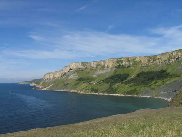 📷 5
📷 5Frequently asked questions
- Where is Ballard Down?
- Ballard Down is in South-East England, United Kingdom (postcode BH19 1RL), in the parish of Swanage.
- What is Ballard Down?
- Ballard Down — Named summit at 160 m.
- How do I get to Ballard Down?
- The nearest railway station is Herston Halt, about 2.4 km away. Drivers can use postcode BH19 1RL.
- Is Ballard Down a protected site?
- Yes — Ballard Down is part of the South Dorset Coast SSSI Site of Special Scientific Interest and the Purbeck Ridge (East) SSSI Site of Special Scientific Interest.
- Is Ballard Down free to visit?
- Yes, Ballard Down is free to enter.
- How do I get to Ballard Down?
- The nearest railway station is Herston Halt, about 2.4 km away. Drivers can navigate to postcode BH19 1RL.