Forts · Northern Ireland
Haughey's Fort
In or near Armagh.
Haughey's Fort in Northern Ireland, United Kingdom.

Kenneth Allen — CC BY-SA 2.0 via Wikimedia Commons licence
Plan your visit
- Typical visit
- 45 min–1.5 h
About
Haughey's Fort is a place of interest in Northern Ireland, United Kingdom — drawn from open-data sources for visitor reference. See the linked Wikipedia article for the full description.
Photo gallery
From the Wikipedia article
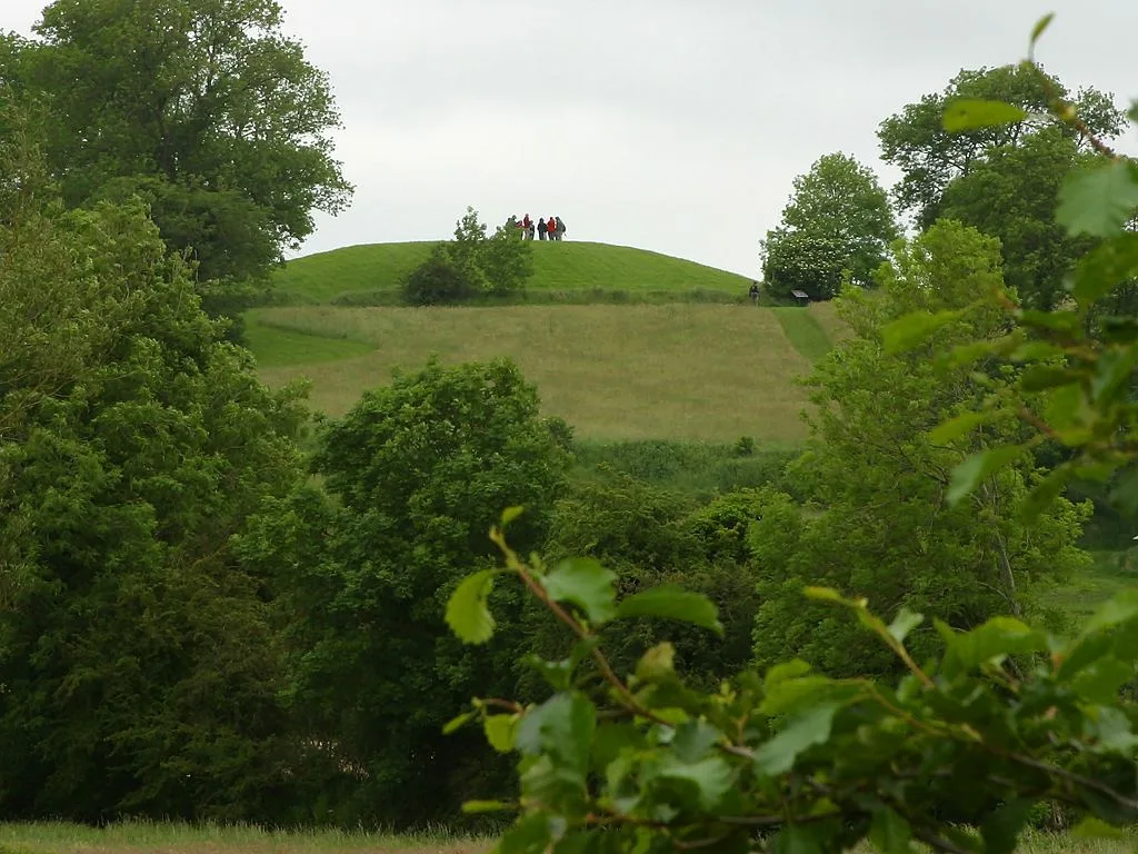
Haughey's Fort is a hill fort in County Armagh, Northern Ireland, 2+1⁄4 miles (3.6 km) west of the city of Armagh. It is named after the farmer who owned the land it is situated on in the later 19th century. The large hilltop enclosure that is Haughey's Fort is a Scheduled Historic Monument in the townland of Tray, in Armagh City and District Council area, at grid ref: H8351 4529. It consists of an oval enclosure, 350 metres (1,150 feet) across at its widest point, surrounded by two concentric ditches. Inside the enclosure another ditch encloses an area 150 metres (490 feet) in diameter. Archaeological excavation shows that it was occupied in the late Bronze Age, ca. 1100 to 900 BC, after which it was abandoned, although some artefacts discovered were of Iron Age date, suggesting that it was later reoccupied. It was contemporary with the nearby artificial pool known as the King's Stables but was abandoned before Navan Fort, 0.6 miles (0.97 km) to the east, was occupied.
Excerpt from Wikipedia under CC BY-SA 4.0. See the source article linked in Sources below.
- Coordinates
- 54.3496, -6.7162
- Postcode
- BT60 4PT
- Parliamentary constituency
- Fermanagh and South Tyrone
Sources
- wikidata: Q5682429 (CC0)
- wikipedia: Haughey's Fort (CC BY-SA 4.0)
Other places nearby

The King's Stables
Archaeological sites · 0.4 km
Navan Fort
Hill forts · 0.5 km

Creeveroe
Natural landmarks · 0.6 km

Navan Centre and Fort
Forts · 1.1 km

Pearse Óg GAC
Natural landmarks · 2.5 km

Milford
Natural landmarks · 2.7 km

Millford
Villages · 2.8 km

Killylea railway station
Natural landmarks · 3.3 km

St Catherine's College Armagh
Historic churches · 3.4 km

Milford (CKAR) railway station
Natural landmarks · 3.4 km

Madden Raparees GAC
Natural landmarks · 3.6 km

Athletic Grounds
Stadiums · 3.6 km
Nearby
📷 5Archaeological sites · Northern Ireland
The King's Stables
The King's Stables — a archaeological in northern-ireland, United Kingdom.
📷 5Hill forts · Northern Ireland
Navan Fort
Navan Fort — archaeological site in County Armagh, Northern Ireland, UK.
📷 3📷 3Forts · Northern Ireland
Navan Centre and Fort
Navan Centre and Fort — a other in northern-ireland, United Kingdom.
📷 3Natural landmarks · Northern Ireland
Pearse Óg GAC
Pearse Óg GAC in Northern Ireland, United Kingdom.
📷 3Where to eat & stay near Haughey's Fort
Places to stay
 📷 5
📷 5 📷 5
📷 5 📷 5
📷 5Caravan parks · Northern Ireland
Dungannon Park Caravan & Camping
Dungannon Park Caravan & Camping — a caravan park in northern ireland.
 📷 5
📷 5Caravan parks · Northern Ireland
Dungannon Park Caravan & Camping
Dungannon Park Caravan & Camping — a caravan park in northern ireland.
 📷 4
📷 4Caravan parks · Northern Ireland
Clare Glen Caravan Park
Clare Glen Caravan Park — a caravan park in northern ireland.
Places to eat & drink
 📷 5
📷 5More forts in this region
 📷 3
📷 3Forts · Northern Ireland
Battle of Antrim 1798
Battle of Antrim 1798 is a fort in the United Kingdom.
.jpg?width=1200) 📷 3
📷 3Forts · Northern Ireland
Battle of Benburb 1646
Battle of Benburb 1646 is a fort in the United Kingdom.
 📷 5
📷 5 📷 3
📷 3Forts · Northern Ireland
Battle of Knockavoe Battlefield
Battle of Knockavoe Battlefield is a fort in the United Kingdom.
Frequently asked questions
- Where is Haughey's Fort?
- Haughey's Fort is in Northern Ireland, United Kingdom (postcode BT60 4PT).
- What is Haughey's Fort?
- Haughey's Fort in Northern Ireland, United Kingdom.
- How do I get to Haughey's Fort?
- Drivers can use postcode BT60 4PT.
- How do I get to Haughey's Fort?
- Drivers can navigate to postcode BT60 4PT. It sits within the Fermanagh and South Tyrone parliamentary constituency.