
Museums · South East England
Fordingbridge
In or near Breamore.
Fordingbridge is a town and broader civil parish with a population of 6,200 on the River Avon in the New Forest District of Hampshire, England. It is located near the Dorset and Wiltshire borders and

Maigheach-gheal — CC BY-SA 2.0 via Wikimedia Commons licence

Plan your visit
- Typical visit
- 1.5 h–3 h
- Best time of year
- Year-round
- Nearest railway station
- Kingsmere · 9.3 km
- Family-friendly
- Limited wheelchair access
Getting there & planning your visit
To visit Fordingbridge Museum, the nearest railway station is Kingsmere, located 9.3 km away. The postcode for sat-nav is SP6 1AB. Entry has limited wheelchair accessibility.
About
Fordingbridge is a town and broader civil parish with a population of 6,200 on the River Avon in the New Forest District of Hampshire, England. It is located near the Dorset and Wiltshire borders and on the edge of the New Forest. It is 81 miles (130 km) southwest of London, and 10 miles (16 km) south of the city of Salisbury. Fordingbridge is a former market town famed for its seven-arch late medieval bridge, which crosses the River Avon at the centre of the town. The Avon Valley Path passes through the town. Since 1982 Fordingbridge has been twinned with Vimoutiers in Normandy, France.
Photo gallery
See it from the streetimagery from 2020
Imagery © Mapillary contributors, CC BY-SA 4.0
Summary from the official site
Fordingbridge is a civil parish located in the New Forest area of England. It is known for its historical significance and scenic surroundings, offering visitors a glimpse into local culture and nature.
Read more on the official property page.
Protected designations
- Site of Special Scientific Interest: River Avon System SSSI
- Area of Outstanding Natural Beauty: Cranborne Chase & West Wiltshire Downs
Designations sourced from Natural England open data under OGL v3.
From the Wikipedia article
Fordingbridge is a town and broader civil parish with a population of 6,200 on the River Avon in the New Forest District of Hampshire, England. It is located near the Dorset and Wiltshire borders and on the edge of the New Forest. It is 81 miles (130 km) southwest of London, and 10 miles (16 km) south of the city of Salisbury. Fordingbridge is a former market town famed for its seven-arch late medieval bridge, which crosses the River Avon at the centre of the town. The Avon Valley Path passes through the town. Since 1982 Fordingbridge has been twinned with Vimoutiers in Normandy, France.
Excerpt from Wikipedia under CC BY-SA 4.0. See the source article linked in Sources below.
Background
History
Fordingbridge is recorded in the Domesday Book of 1086 under the name Forde. The manor was held by a certain Robert from "Robert the son of Gerald". From that date Fordingbridge followed the same descent as Rowner. Before 1277 the property had escheated to the Crown by the felony of William de la Falaise, grandson of William, and was granted in that year to Sir William le Brune, chamberlain to the king. which were never rebuilt. Fordingbridge Town Hall, built in 1877, is almost in the centre of the town. Cloth was made here in the 16th century, and in the 19th century there were factories for the manufacture of sailcloth and canvas and the spinning of flax. By 1900 the chief industries of…
Description
]] Known as "The Northern Gateway" to the New Forest, Fordingbridge is popular with tourists, with various campsites, pubs and restaurants, and other tourist facilities locally. The Fordingbridge Museum, which houses many local and New Forest history exhibits, and the Visitor Information Centre are located within King's Yard, Salisbury Street. The town's High Street is well known for its pubs, cafes and local shops. The town also has its own Cinema, within the buildings of a former pottery. Rockbourne Roman Villa is in the nearby village of Rockbourne which sits 3 mi northwest of Fordingbridge. The village of Breamore is 3 miles north of Fordingbridge and is home to Elizabethan country…
Sourced from Wikipedia under CC BY-SA 4.0.
- Coordinates
- 50.9275, -1.7901
- County
- Hampshire
- District
- New Forest
- Parish
- Fordingbridge
- Postcode
- SP6 1AB
- Parliamentary constituency
- New Forest West
- Nearest railway station
- Kingsmere — 9.3 km
- Official site
- explore-local-statistics.beta.ons.gov.uk
Sources
- wikipedia: Fordingbridge (CC BY-SA 4.0)
Other places nearby

Fordingbridge Museum
Museums · 0.1 km

The Crypt
Escape rooms · 0.1 km

The Old Manor House
Historic houses · 0.2 km

Fordingbridge War Memorial Gates
Memorials & monuments · 0.3 km

The Regal Cinema
Cinemas · 0.3 km

St Johns Farm Camping
Campsites · 0.5 km
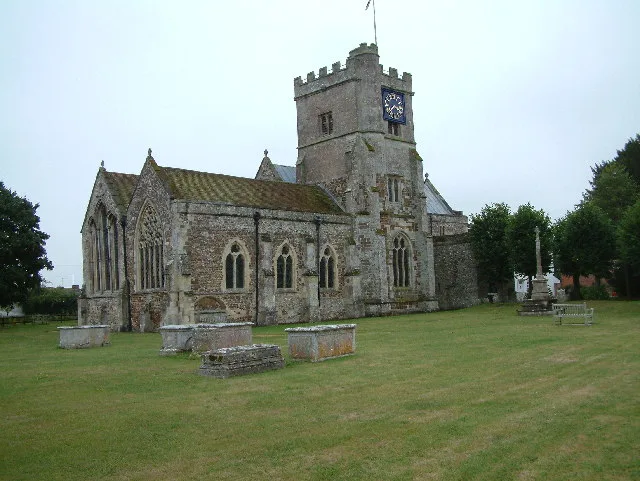
St Mary's Church, Fordingbridge
Historic churches · 0.5 km

Burgate Manor
Manor houses · 0.6 km

Amphitheatre
Theatres · 1.0 km

Good Friday Hill
Mountains & hills · 1.9 km

Giants Grave
Natural landmarks · 2.0 km

Giants Grave
Mountains & hills · 2.0 km
Nearby
📷 5Museums · South East England
Fordingbridge Museum
Fordingbridge Museum — a museum in england-south-east, United Kingdom.
📷 5Escape rooms · South East England
The Crypt
The Crypt — a escape room in england-south-east, United Kingdom.
📷 5Historic houses · South East England
The Old Manor House
The Old Manor House — house in Fordingbridge, New Forest, England, UK.
📷 5Memorials & monuments · South East England
Fordingbridge War Memorial Gates
Fordingbridge War Memorial Gates — Grade II listed building-listed memorial in england-south-east, United Kingdom.
📷 5Cinemas · South East England
The Regal Cinema
The Regal Cinema — a cinema in england south east.
📷 5Campsites · South East England
St Johns Farm Camping
St Johns Farm Camping — a campsite in england south east.
Where to eat & stay near Fordingbridge
Places to stay
📷 5Campsites · South East England
St Johns Farm Camping
St Johns Farm Camping — a campsite in england south east.
 📷 5
📷 5Caravan parks · South East England
Gorse Farm Caravan Park
Gorse Farm Caravan Park — a caravan park in england south east.
📷 7B&Bs · South East England
Croft Cottage B&B
Croft Cottage B&B — a bed-and-breakfast in england south east.
 📷 5
📷 5Campsites · South East England
Harry's Field Campsite
Harry's Field Campsite — a campsite in england south east.
 📷 5
📷 5Campsites · South East England
Hill Cottage Farm
Hill Cottage Farm — a campsite in england south east.
 📷 5
📷 5Campsites · South East England
Greenfields Camp Site
Greenfields Camp Site — a campsite in england south east.
Places to eat & drink
 📷 5
📷 5Historic pubs · South East England
The Old Beams Inn
The Old Beams Inn in England South West, United Kingdom.
 📷 5
📷 5Historic pubs · South East England
The Cart Wheel Public House
The Cart Wheel Public House in England South West, United Kingdom.
 📷 5
📷 5Historic pubs · South East England
The Alice Lisle
The Alice Lisle — Historic pub — listed building or notable heritage status.
 📷 7
📷 7Historic pubs · South West England
The White Horse Inn
The White Horse Inn in England South West, United Kingdom.
 📷 7
📷 7Historic pubs · South West England
The Wooden Spoon
The Wooden Spoon in England South West, United Kingdom.
 📷 5
📷 5Historic pubs · South East England
The White Hart
The White Hart — Historic pub — listed building or notable heritage status.
More museums in this region
 📷 5
📷 5Museums · South East England
Coldrum Long Barrow
Coldrum Long Barrow — neolithic chambered long barrow near Trottiscliffe, Kent, England, UK.
 📷 5
📷 5Museums · South East England
Guildford House
Guildford House — house in Guildford, Surrey, England, UK.
 📷 5
📷 5Museums · South East England
Huguenot Museum
Huguenot Museum — museum in Rochester, England, UK.
 📷 5
📷 5Museums · South East England
Medway megaliths
Medway megaliths — group of long barrows in Kent, England.
Frequently asked questions
- Where is Fordingbridge?
- Fordingbridge is in Hampshire, South-East England, United Kingdom (postcode SP6 1AB), in the parish of Fordingbridge.
- What is Fordingbridge?
- Fordingbridge is a town and broader civil parish with a population of 6,200 on the River Avon in the New Forest District of Hampshire, England. It is located near the Dorset and Wiltshire borders and
- How do I get to Fordingbridge?
- The nearest railway station is Kingsmere, about 9.3 km away. Drivers can use postcode SP6 1AB.
- Is Fordingbridge a protected site?
- Yes — Fordingbridge is part of the River Avon System SSSI Site of Special Scientific Interest and the Cranborne Chase & West Wiltshire Downs National Landscape (AONB).
- How do I get to Fordingbridge?
- Drivers can navigate to postcode SP6 1AB. It sits within the New Forest West parliamentary constituency.