
Museums · South East England
New Forest District
In or near Brockenhurst.
New Forest is a local government district in Hampshire, England. Its council is based in Lyndhurst, although the largest town is Totton. The district also includes the towns of Fordingbridge, Lymingto

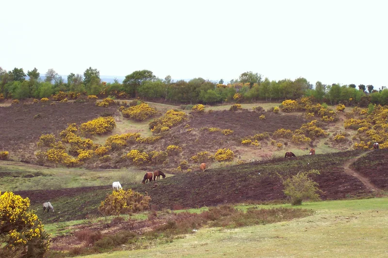
Jim Champion — CC BY-SA 2.0 via Wikimedia Commons licence

Plan your visit
- Typical visit
- 1.5 h–3 h
- Best time of year
- Year-round
- Nearest railway station
- Ashurst New Forest · 7.6 km
- Family-friendly
- Limited wheelchair access
Getting there & planning your visit
To visit the New Forest District museum, the nearest railway station is Ashurst New Forest, located 7.6 km away. The postcode for navigation is SO43 7GE. Please note that wheelchair accessibility is limited.
About
New Forest is a local government district in Hampshire, England. Its council is based in Lyndhurst, although the largest town is Totton. The district also includes the towns of Fordingbridge, Lymington, New Milton and Ringwood. The district is named after and covers most of the New Forest National Park, which occupies much of the central part of the district. The main urban areas are around the periphery of the forest. The district has a coastline onto the Solent to the south and Southampton Water to the east. The neighbouring districts are Bournemouth, Christchurch and Poole, Dorset, Wiltshire, Test Valley, Southampton and Eastleigh (across Southampton Water). The district also faces the Isle of Wight across the Solent.
Photo gallery
Protected designations
- Site of Special Scientific Interest: Lymington River SSSI
- Site of Special Scientific Interest: The New Forest SSSI
- Ramsar wetland: New Forest
Designations sourced from Natural England open data under OGL v3.
From the Wikipedia article
New Forest is a local government district in Hampshire, England. Its council is based in Lyndhurst, although the largest town is Totton. The district also includes the towns of Fordingbridge, Lymington, New Milton and Ringwood. The district is named after and covers most of the New Forest National Park, which occupies much of the central part of the district. The main urban areas are around the periphery of the forest. The district has a coastline onto the Solent to the south and Southampton Water to the east. The neighbouring districts are Bournemouth, Christchurch and Poole, Dorset, Wiltshire, Test Valley, Southampton and Eastleigh (across Southampton Water). The district also faces the Isle of Wight across the Solent.
Excerpt from Wikipedia under CC BY-SA 4.0. See the source article linked in Sources below.
Background
History
The district was created on 1 April 1974 under the Local Government Act 1972, covering the whole area of two former districts and most of a third, which were all abolished at the same time: The new district was named New Forest after the forest which covers much of the area. New Forest is one of the most populous districts in England not to be a unitary authority; at the 2021 census only four non-unitary districts had more people. The Banham Commission had recommended that New Forest should become a unitary authority in 1995, but this was rejected by the government. Under upcoming local government reform plans the district will be merged with others to form the new Mid Hampshire unitary…
Sourced from Wikipedia under CC BY-SA 4.0.
- Coordinates
- 50.8790, -1.6330
- County
- Hampshire
- District
- New Forest
- Parish
- Minstead
- Postcode
- SO43 7GE
- Parliamentary constituency
- New Forest East
- Nearest railway station
- Ashurst New Forest — 7.6 km
Sources
- wikipedia: New Forest District (CC BY-SA 4.0)
Other places nearby

Acres Down South
Viewpoints · 1.2 km

Acres Down
Mountains & hills · 1.2 km

Portuguese Fireplace
Memorials & monuments · 1.3 km

Hart Hill
Mountains & hills · 1.4 km
Acres Down Farm
Campsites · 1.4 km

Bolderwood Hill
Mountains & hills · 1.5 km

Bolderwood Deer Sanctuary
Viewpoints · 1.8 km

Canadian Memorial
Memorials & monuments · 1.9 km

Lucas Castle
Mountains & hills · 2.0 km
New Forest
National parks · 2.1 km

New Forest
Battlefields & battle sites · 2.1 km
New Forest Reptile Centre
Zoos & aquariums · 2.1 km
Nearby
📷 5Viewpoints · South East England
Acres Down South
Acres Down South is a viewpoint in the United Kingdom.
📷 5Mountains & hills · South East England
Acres Down
Acres Down — mountain in england south east. Elevation: 93 m.
📷 5Memorials & monuments · South East England
Portuguese Fireplace
Portuguese Fireplace — a memorial in england-south-east, United Kingdom.
📷 5Mountains & hills · South East England
Hart Hill
Hart Hill — mountain in england south east. Elevation: 104 m. Operated by Ordnance Survey.
📷 5Campsites · South East England
Acres Down Farm
Acres Down Farm — a campsite in england south east.
📷 5Mountains & hills · South East England
Bolderwood Hill
Bolderwood Hill — mountain in england south east. Elevation: 103 m.
Where to eat & stay near New Forest District
Places to stay
📷 5Campsites · South East England
Acres Down Farm
Acres Down Farm — a campsite in england south east.
 📷 3
📷 3Campsites · South East England
Minstead Manor Farm Camping
Minstead Manor Farm Camping — a campsite in england south east.
 📷 5
📷 5Campsites · South East England
Ocknell
Ocknell — a campsite in england south east.
 📷 5
📷 5Hotels · South East England
Forest Lodge Hotel
Forest Lodge Hotel — a hotel in england south east.
 📷 7
📷 7Hotels · South East England
The Crown Manor House Hotel
The Crown Manor House Hotel — a hotel in england south east.
 📷 5
📷 5Places to eat & drink
 📷 7
📷 7Historic pubs · South East England
Green Dragon Inn
Green Dragon Inn in England South West, United Kingdom.
 📷 5
📷 5Historic pubs · South East England
Sir John Barleycorn Inn
Sir John Barleycorn Inn in England South East, United Kingdom.
 📷 7
📷 7Historic pubs · South East England
Rose And Crown Hotel
Rose And Crown Hotel in England South East, United Kingdom.
 📷 5
📷 5 📷 5
📷 5Historic pubs · South East England
The Alice Lisle
The Alice Lisle — Historic pub — listed building or notable heritage status.
 📷 5
📷 5Historic pubs · South East England
The White Hart
The White Hart — Historic pub — listed building or notable heritage status.
More museums in this region
 📷 5
📷 5Museums · South East England
Coldrum Long Barrow
Coldrum Long Barrow — neolithic chambered long barrow near Trottiscliffe, Kent, England, UK.
 📷 5
📷 5Museums · South East England
Guildford House
Guildford House — house in Guildford, Surrey, England, UK.
 📷 5
📷 5Museums · South East England
Huguenot Museum
Huguenot Museum — museum in Rochester, England, UK.
 📷 5
📷 5Museums · South East England
Medway megaliths
Medway megaliths — group of long barrows in Kent, England.
Frequently asked questions
- Where is New Forest District?
- New Forest District is in Hampshire, South-East England, United Kingdom (postcode SO43 7GE), in the parish of Minstead.
- What is New Forest District?
- New Forest is a local government district in Hampshire, England. Its council is based in Lyndhurst, although the largest town is Totton. The district also includes the towns of Fordingbridge, Lymingto
- How do I get to New Forest District?
- The nearest railway station is Ashurst New Forest, about 7.6 km away. Drivers can use postcode SO43 7GE.
- Who owns New Forest District?
- New Forest District is owned by New Forest District Council.
- Is New Forest District a protected site?
- Yes — New Forest District is part of the Lymington River SSSI Site of Special Scientific Interest and the The New Forest SSSI Site of Special Scientific Interest.
- How do I get to New Forest District?
- The nearest railway station is Ashurst New Forest, about 7.6 km away. Drivers can navigate to postcode SO43 7GE.