
Mountains & hills · North West England
Flood Entrance Pot
In or near Clapham.
Flood Entrance Pot is a mountain or hill in the United Kingdom.

Wikimedia Commons contributors — see linked file page for photographer and licence licence

Plan your visit
- Typical visit
- 3 h–8 h
- Best time of year
- Late spring – early autumn (May–Oct)
- Nearest railway station
- Clapham · 5.0 km
- Free entry
- Dog-friendly
Getting there & planning your visit
To visit Flood Entrance Pot, the nearest railway station is Clapham, which is 5 km away. The postcode for the site is LA2 8EE, and entry is free.
About
Flood Entrance Pot is a named summit in the United Kingdom. Coordinates: 54.1469°, -2.3821°. This entry is part of The Great Britain Guide, a free, ad-free, open-data tourist directory.
Photo gallery
Protected designations
- Site of Special Scientific Interest: Ingleborough SSSI
- National Nature Reserve: INGLEBOROUGH
Designations sourced from Natural England open data under OGL v3.
From the Wikipedia article
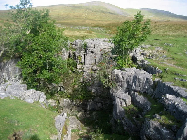
Flood Entrance Pot (sometimes known as Flood Exit Pot) is one of the entrances to the Gaping Gill cave system located about 300 metres (330 yd) south of Gaping Gill Main Shaft. It was the first alternative entrance into the main system to be explored, and it is now a popular entrance into the system, with a fine 38-metre (125 ft) pitch landing in Gaping Gill's South-East Passage. It lies within the designated Ingleborough Site of Special Scientific Interest.
Excerpt from Wikipedia under CC BY-SA 4.0. See the source article linked in Sources below.
Background
History
South-East Pot was discovered and free-climbed down to a depth of 15 m in 1906 by the Yorkshire Ramblers' Club during a Winch Meet. They commented on the high aven above it, which later proved to be the last Pitch of Flood Entrance Pot. The shaft was bottomed in May of the following year. Flood Entrance Pot was first entered in 1909 by the Yorkshire Speleological Association who were motivated to look for an entrance after finding some flies and a red worm at the bottom of South-East Pot. They concluded that these must have come from the surface having descended the high aven above. It gained its name as it allowed the Gaping Gill system to be entered even when the Main Shaft was in flood.…
Description
A climb down in the small shakehole soon leads to a tight 15 m pitch. At the bottom the passage passes beneath the aven where Wade's Entrance joins, and after a further 80 m it goes round a series of bends to where the last pitch of OBJ Hole enters. There is a chamber after a further 30 m where a small stream enters from an inlet passage. Downstream a succession of climbs and a 14 m pitch reach the main pitch of 77 m. South-East Passage in Gaping Gill may be stepped into at the -38 m level, but the shaft continues in two stages as South-East Pot to a 29 m deep pool. Above the final shaft there is a tight passage, Horrocks-Stearn Crawl, which connects to Bar Pot above its main pitch. Wade's…
Sourced from Wikipedia under CC BY-SA 4.0.
- Coordinates
- 54.1469, -2.3821
- District
- North Yorkshire
- Parish
- Clapham cum Newby
- Postcode
- LA2 8EE
- Parliamentary constituency
- Skipton and Ripon
- Nearest railway station
- Clapham — 5 km
- Official site
- www.cncc.org.uk
Sources
- wikidata: Q16246477 (CC0)
- wikipedia: Flood Entrance Pot (CC BY-SA 4.0)
- commons: Flood Entrance Pot.jpg (CC BY-SA 4.0)
Other places nearby

Flood Entrance Pot
Caves · 0.0 km

Wades Entrance
Caves · 0.0 km
Bar Pot
Mountains & hills · 0.1 km

Bar Pot
Caves · 0.1 km

Small Mammal Pot
Caves · 0.1 km
Disappointment Pot
Mountains & hills · 0.1 km
Marilyn
Caves · 0.1 km
Stile Pot
Caves · 0.1 km

Henslers Pot
Caves · 0.2 km

Disappointment Pot
Caves · 0.2 km

Gaping Gill
Caves · 0.3 km
Jib Tunnel
Mountains & hills · 0.3 km
Nearby
📷 3Caves · North West England
Flood Entrance Pot
Flood Entrance Pot is a cave in the United Kingdom.
📷 5Caves · North West England
Wades Entrance
Wades Entrance — a cave broad in england-north-west, United Kingdom.
📷 3Mountains & hills · North West England
Bar Pot
Bar Pot is a mountain or hill in the United Kingdom.
📷 3📷 3Caves · North West England
Small Mammal Pot
Small Mammal Pot is a cave in the United Kingdom.
📷 3Mountains & hills · North West England
Disappointment Pot
Disappointment Pot is a mountain or hill in the United Kingdom.
Where to eat & stay near Flood Entrance Pot
Places to stay
 📷 5
📷 5 📷 5
📷 5Campsites · North West England
Silloth House Campsite
Silloth House Campsite — a campsite in england north west.
 📷 5
📷 5Hotels · North West England
The Traddock
The Traddock — a hotel in england north west.
 📷 5
📷 5Campsites · North West England
The Dalesbridge
The Dalesbridge — a campsite in england north west.
 📷 5
📷 5 📷 5
📷 5Caravan parks · North West England
Orcaber Farm Camping
Orcaber Farm Camping — a caravan park in england north west.
Places to eat & drink
 📷 5
📷 5Cafés · North West England
Lakehouse Food & Drink
Lakehouse Food & Drink — a café in england north west.
 📷 5
📷 5Restaurants · North West England
The Game Cock Inn
The Game Cock Inn — a restaurant in england north west. Cuisine: french;english.
 📷 5
📷 5Historic pubs · North West England
Horse And Farrier Inn
Horse And Farrier Inn in England North West, United Kingdom.
 📷 5
📷 5Historic pubs · North West England
Punch Bowl Hotel
Punch Bowl Hotel in England North West, United Kingdom.
 📷 5
📷 5 📷 6
📷 6Historic pubs · North West England
Falcon Manor Hotel
Falcon Manor Hotel in England North West, United Kingdom.
More mountains in this region
 📷 5
📷 5Mountains & hills · North West England
Appleton Park
Appleton Park — a hill or mountain in england west midlands.
 📷 5
📷 5Mountains & hills · North West England
High Warren
High Warren — mountain in england west midlands. Elevation: 105 m.
 📷 5
📷 5Mountains & hills · North West England
Alderley Edge
Alderley Edge — mountain in england west midlands. Elevation: 194 m.
 📷 3
📷 3Frequently asked questions
- Where is Flood Entrance Pot?
- Flood Entrance Pot is in North-West England, United Kingdom (postcode LA2 8EE), in the parish of Clapham cum Newby.
- What is Flood Entrance Pot?
- Flood Entrance Pot is a mountain or hill in the United Kingdom.
- How do I get to Flood Entrance Pot?
- The nearest railway station is Clapham, about 5.0 km away. Drivers can use postcode LA2 8EE.
- Is Flood Entrance Pot a protected site?
- Yes — Flood Entrance Pot is part of the Ingleborough SSSI Site of Special Scientific Interest and the INGLEBOROUGH National Nature Reserve.
- Is Flood Entrance Pot free to visit?
- Yes, Flood Entrance Pot is free to enter.
- How do I get to Flood Entrance Pot?
- The nearest railway station is Clapham, about 5.0 km away. Drivers can navigate to postcode LA2 8EE.