
Archaeological sites · Northern Ireland
Dromore, County Down
In or near Lurganville.
Dromore (from Irish Droim Mór, meaning 'large ridge') is a small market town and civil parish in County Down, Northern Ireland. It lies within the local government district of Armagh City, Banbridge a

Kenneth Allen — CC BY-SA 2.0 via Wikimedia Commons licence
_-_geograph.org.uk_-_1690880.jpg)
Plan your visit
- Typical visit
- 45 min–1.5 h
- Nearest railway station
- Moira · 9.6 km
- Free entry
- Dog-friendly
About
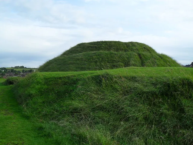
Dromore (from Irish Droim Mór, meaning 'large ridge') is a small market town and civil parish in County Down, Northern Ireland. It lies within the local government district of Armagh City, Banbridge and Craigavon. It is 19 miles (31 km) southwest of Belfast, on the A1 Belfast–Dublin road. The 2021 census recorded a population of 6,492. The town's centre is Market Square, which has a rare set of stocks. It is in the old linen manufacturing district. Dromore has the remains of a castle and earthworks, although these have modern buildings surrounding them, a large motte and bailey or encampment (known locally as "the Mound"), and an earlier earthwork known as the Priest's Mount on the Maypole Hill.
Photo gallery
From the Wikipedia article
Dromore (from Irish Droim Mór, meaning 'large ridge') is a small market town and civil parish in County Down, Northern Ireland. It lies within the local government district of Armagh City, Banbridge and Craigavon. It is 19 miles (31 km) southwest of Belfast, on the A1 Belfast–Dublin road. The 2021 census recorded a population of 6,492. The town's centre is Market Square, which has a rare set of stocks. It is in the old linen manufacturing district. Dromore has the remains of a castle and earthworks, although these have modern buildings surrounding them, a large motte and bailey or encampment (known locally as "the Mound"), and an earlier earthwork known as the Priest's Mount on the Maypole Hill.
Excerpt from Wikipedia under CC BY-SA 4.0. See the source article linked in Sources below.
Background
History
The name Dromore is an anglicisation of the Irish Druim Mór (modern Irish Droim Mór) meaning "large ridge", with historic anglicisations including Drumore, Drummore and Drummor. The town features a well-preserved Norman motte and bailey that was constructed by John de Courcy in the early 13th century, shortly after the Norman invasion of Ireland. Known locally as "the Mound", the fort occupies a prominent site to the east of the town centre and has views along the valley of the River Lagan. Dromore remained under Anglo-Norman control until it was captured and destroyed by Edward Bruce during the Irish-Bruce wars of 1315. It was the seat of the diocese of Dromore, which grew out of an abbey…
Description
1976 7 April 1976 – William Herron (64), Elizabeth Herron (58) and their daughter, Noleen Herron (26), all Protestant civilians, were killed during a Provisional Irish Republican Army incendiary bomb attack on their drapery shop on Market Square, Dromore. They lived in the flat above the shop. 1988 6 July 1988 – Terence Delaney (31), a Catholic civilian, was shot dead by the Ulster Freedom Fighters, a cover name used by the Ulster Defence Association, while waiting for a lift to work.
Visiting
]] The Dromore Town Centre Development Plan, published in July 2003, outlined that of the 190 units within Dromore Town Centre, over one quarter were vacant. This is in spite of recent population growth in the town; a result of the proximity to the A1 road and resultant commuting access to Greater Belfast. The green-field development in recent years has mostly been around the edges of the town, and the doughnut effect has led to these houses being disconnected from the town centre. The population of Dromore tends to travel to nearby Banbridge or Sprucefield to shop, which has caused the high levels of obvious dereliction however more local shops are opening thus the number of people…
Sourced from Wikipedia under CC BY-SA 4.0.
- Coordinates
- 54.4150, -6.1490
- Postcode
- BT25 1BG
- Parliamentary constituency
- Lagan Valley
- Nearest railway station
- Moira — 9.6 km
Sources
- wikipedia: Dromore, County Down (CC BY-SA 4.0)
Other places nearby

War Memorial
Memorials & monuments · 0.1 km
Dromore Town Hall
Historic houses · 0.1 km

Dromore Cinema
Theatres · 0.1 km

Dromore
Villages · 0.1 km

Dromore Cathedral
Cathedrals · 0.2 km

Dromore Castle
Castles · 0.2 km

Brown's Mount
Archaeological sites · 0.2 km

St Colman's Primary School, Dromore
Historic churches · 0.3 km
Motte And Bailey
Hill forts · 0.4 km

Dromore Motte and Bailey
Archaeological sites · 0.4 km

Bishop Thomas Percy Monument
Memorials & monuments · 0.5 km

Dromore railway station
Natural landmarks · 0.5 km
Nearby
📷 5Memorials & monuments · Northern Ireland
War Memorial
War Memorial is a memorial in the United Kingdom.
📷 4Historic houses · Northern Ireland
Dromore Town Hall
Dromore Town Hall in Northern Ireland, United Kingdom.
📷 3📷 5📷 4Cathedrals · Northern Ireland
Dromore Cathedral
Dromore Cathedral in Northern Ireland, United Kingdom.
📷 3Castles · Northern Ireland
Dromore Castle
Dromore Castle — a castle in northern-ireland, United Kingdom.
Where to eat & stay near Dromore, County Down
Places to stay
 📷 5
📷 5Campsites · Northern Ireland
Slieve Croob Camping
Slieve Croob Camping — a campsite in northern ireland.
 📷 5
📷 5Caravan parks · Northern Ireland
Kinnego Marina Camping & Caravanning
Kinnego Marina Camping & Caravanning — a caravan park in northern ireland.
 📷 4
📷 4Caravan parks · Northern Ireland
Clare Glen Caravan Park
Clare Glen Caravan Park — a caravan park in northern ireland.
 📷 5
📷 5Campsites · Northern Ireland
Castlewellan Touring-in-the-Trees
Castlewellan Touring-in-the-Trees — a campsite in northern ireland.
 📷 5
📷 5Campsites · Northern Ireland
Castlewellan Forest Park - Camping
Castlewellan Forest Park - Camping — a campsite in northern ireland.
Places to eat & drink
 📷 3
📷 3Historic pubs · Northern Ireland
Soma Festival
The Soma Festival (Sanskrit: सोम, or sóma, meaning drink of the Gods, see Soma (drink); Irish: Féile Soma) is an annual music, arts, and cultural festival. The festival includes concerts, musical perf
 📷 5
📷 5 📷 3
📷 3Historic pubs · Northern Ireland
Red Lion Pub bombing
Red Lion Pub bombing in Northern Ireland, United Kingdom.
 📷 7
📷 7Historic pubs · Northern Ireland
Crown Liquor Saloon
Crown Liquor Saloon in Northern Ireland, United Kingdom.
 📷 7
📷 7Historic pubs · Northern Ireland
Kelly's Cellars
Kelly's Cellars in Northern Ireland, United Kingdom.
More archaeological sites in this region
 Flagship📷 5
Archaeological sites · Northern Ireland
Tollymore Forest Park
Tollymore Forest Park — park in the United Kingdom.
 📷 3
📷 3Archaeological sites · Northern Ireland
Annalong Forest
Annalong Forest — Forest in County Down, Northern Ireland.
 📷 3
📷 3Archaeological sites · Northern Ireland
Ballysallagh Forest
Ballysallagh Forest — forest in Northern Ireland.
 📷 3
📷 3Archaeological sites · Northern Ireland
Castleward Forest
Castleward Forest — castleward Forest: Northern Ireland.
Frequently asked questions
- Where is Dromore, County Down?
- Dromore, County Down is in Northern Ireland, United Kingdom (postcode BT25 1BG).
- What is Dromore, County Down?
- Dromore (from Irish Droim Mór, meaning 'large ridge') is a small market town and civil parish in County Down, Northern Ireland. It lies within the local government district of Armagh City, Banbridge a
- How do I get to Dromore, County Down?
- The nearest railway station is Moira, about 9.6 km away. Drivers can use postcode BT25 1BG.
- Is Dromore, County Down free to visit?
- Yes, Dromore, County Down is free to enter.
- How do I get to Dromore, County Down?
- Drivers can navigate to postcode BT25 1BG. It sits within the Lagan Valley parliamentary constituency.