Islands · South West England
Drake's Island
Drake's Island is a island in the United Kingdom.

Wikimedia Commons contributors — see linked file page for photographer and licence licence
Plan your visit
- Typical visit
- 4 h–12 h
- Nearest railway station
- Plymouth · 2.6 km
- Free entry
- Dog-friendly
About
Drake's Island is a island in the United Kingdom. Part of British Isles. Coordinates: 50.3556°, -4.1536°. This entry is part of The Great Britain Guide, a free, ad-free, open-data tourist directory.
Photo gallery
Protected designations
- Site of Special Scientific Interest: Plymouth Sound Shores and Cliffs SSSI
Designations sourced from Natural England open data under OGL v3.
From the Wikipedia article
Drake's Island is a 6.5-acre (2.6-hectare) island approximately 500 metres from land in Plymouth Sound, the stretch of water south of the city of Plymouth, Devon. The rocks which make up the island are volcanic tuff and lava, together with marine limestone of the Devonian period. For more than 400 years the island was fortified.
Excerpt from Wikipedia under CC BY-SA 4.0. See the source article linked in Sources below.
- Coordinates
- 50.3556, -4.1536
- District
- Plymouth
- Parish
- Plymouth, unparished area
- Postcode
- PL1 3DQ
- Parliamentary constituency
- Plymouth Sutton and Devonport
- Nearest railway station
- Plymouth — 2.6 km
- Official site
- drakes-island.com
Sources
- wikidata: Q1255576 (CC0)
- wikipedia: Drake's Island (CC BY-SA 4.0)
- commons: Drakes island high.jpg (CC BY-SA 4.0)
Other places nearby
Loading nearby places…
Nearby
 📷 5
📷 5Historic houses · South West England
Commanding Officers House
Commanding Officers House — house in Plymouth, Devon, England, UK.
Lidos & outdoor pools · South West England
Devil's Point pool
Devil's Point pool — a lido in england south west.
 📷 3
📷 3Memorials & monuments · South West England
Firestone Bay artillery tower
Firestone Bay artillery tower — scheduled monument-listed memorial in england-south-west, United Kingdom.
 📷 5
📷 5Piers · South West England
Look II
Look II — Public artwork (sculpture) by Antony Gormley.
 📷 4
📷 4Public art & sculpture · South West England
LOOK II
LOOK II in England South West, United Kingdom.
 📷 5
📷 5Museums · South West England
River Tamar
River Tamar — a museum in england-south-west, United Kingdom.
More places in this region
 Flagship📷 10
Islands · South West England
Annet
Annet — island in Isles of Scilly, United Kingdom.
 Flagship📷 10
Islands · South West England
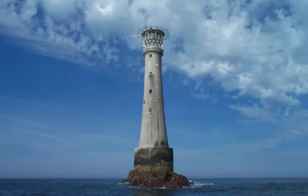
Bishop Rock
Bishop Rock — islet in the Atlantic Ocean, at the Isles of Scilly, England.
 Flagship📷 10
Islands · South West England
Bryher
Bryher — island of the Isles of Scilly, Cornwall, England.
 📷 8
📷 8Islands · South West England
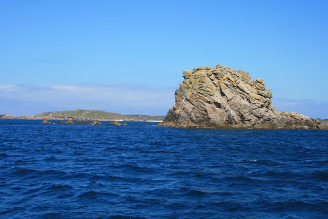
Castle Bryher
Castle Bryher — island in Isles of Scilly, United Kingdom.
Frequently asked questions
- Where is Drake's Island?
- Drake's Island is in South-West England, United Kingdom (postcode PL1 3DQ), in the parish of Plymouth, unparished area.
- Is Drake's Island a protected site?
- Yes — Drake's Island is part of the Plymouth Sound Shores and Cliffs SSSI Site of Special Scientific Interest.
- Is Drake's Island free to visit?
- Yes, Drake's Island is free to enter.
- How do I get to Drake's Island?
- The nearest railway station is Plymouth, about 2.6 km away. Drivers can navigate to postcode PL1 3DQ.