
Piers · East of England
Curve Water Sports
In or near Jaywick.
Curve Water Sports is a pier in the United Kingdom.

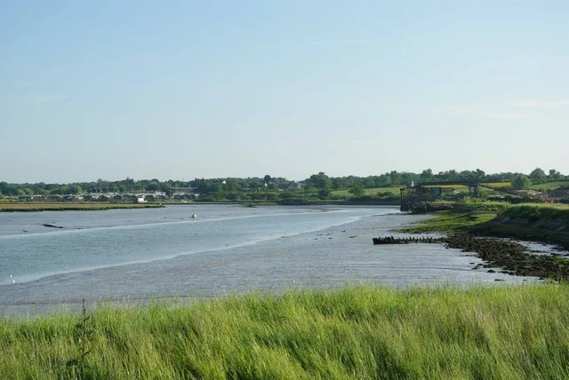
M J Richardson — CC BY-SA 2.0 via Wikimedia Commons licence

Plan your visit
- Typical visit
- 30 min–1 h
- Best time of year
- Summer
- Nearest railway station
- Clacton-on-Sea · 6.0 km
- Free entry
- Family-friendly
- Dog-friendly
- Limited wheelchair access
About
Curve Water Sports is a seaside pier on the coast of Essex, East of England — Victorian pleasure architecture on stilts, still standing. The site is a designated Site of Special Scientific Interest, and is a Ramsar wetland of international importance. It sits within the Clacton parliamentary constituency. The nearest railway station is Clacton-on-Sea, about 6.0 km away. Postcode area CO16.
Photo gallery
See it from the streetimagery from 2023
Imagery © Mapillary contributors, CC BY-SA 4.0
Official information
Curve Water Sports is an outdoor water activity destination in Essex, offering a variety of fun activities for all ages, including wakeboarding, paddleboarding, kayaking, and an inflatable Aqua Park. Visitors can enjoy a full day of adventure on the water, making it a great spot for families and friends.
Protected designations
- Site of Special Scientific Interest: Colne Estuary SSSI
- Ramsar wetland: Colne Estuary (Mid-Essex Coast Phase 2)
Designations sourced from Natural England open data under OGL v3.
Place summary
Curve Water Sports is a pier located in St Osyth, Essex, in the East of England. It is situated within the Colne Estuary, designated as a Site of Special Scientific Interest (SSSI) and a RAMSAR site. These designations highlight the area's ecological significance and biodiversity.
AI-generated from the structured facts on this page (operator, designation, listing, era). Not a substitute for visiting.
- Coordinates
- 51.7971, 1.0672
- County
- Essex
- District
- Tendring
- Parish
- St Osyth
- Postcode
- CO16 8EW
- Parliamentary constituency
- Clacton
- Nearest railway station
- Clacton-on-Sea — 6 km
- Official site
- curvewatersports.co.uk
Sources
- osm: w1073361596 (ODbL)
Other places nearby

Harbour Lodge
Campsites · 0.2 km

St Osyth War Memorial
Memorials & monuments · 0.5 km

St Osyth Village Sign
Public art & sculpture · 0.6 km
.jpg?width=1200)
St Osyth's Priory: The Abbot's Lodging and South Wing, the Darcy Clock Tower and C18 House (formerly listed as the Convalescent Home)
Historic houses · 0.6 km
St Osyth's Priory ruined east ranges of the Darcy House including the Tower and Chapel
Memorials & monuments · 0.7 km

St Osyth Museum
Museums · 0.8 km
St Osyth
Museums · 0.9 km

Saint Osyth
Villages · 1.2 km

Howlands Marsh
Forests & woodlands · 1.2 km
Howlands Marsh
Wildlife reserves · 1.5 km

Cindery Island
Islands · 2.5 km

The Creek
Restaurants · 2.6 km
Nearby
📷 5📷 3Memorials & monuments · East of England
St Osyth War Memorial
St Osyth War Memorial — a memorial in england-east, United Kingdom.
📷 3Public art & sculpture · East of England
St Osyth Village Sign
St Osyth Village Sign — a public art in england-east, United Kingdom.
📷 3Historic houses · East of England
St Osyth's Priory: The Abbot's Lodging and South Wing, the Darcy Clock Tower and C18 House (formerly listed as the Convalescent Home)
St Osyth's Priory: The Abbot's Lodging and South Wing, the Darcy Clock Tower and C18 House (formerly listed as the Convalescent Home) — Grade I listed building in St Osyth, Essex, England, UK.
📷 3Memorials & monuments · East of England
St Osyth's Priory ruined east ranges of the Darcy House including the Tower and Chapel
St Osyth's Priory ruined east ranges of the Darcy House including the Tower and Chapel — Grade I listed building-listed memorial in england-east, United Kingdom.
📷 3Museums · East of England
St Osyth Museum
St Osyth Museum — a museum in england-east, United Kingdom.
Where to eat & stay near Curve Water Sports
Places to stay
📷 5 📷 5
📷 5Campsites · East of England
The Partridge Retreat
The Partridge Retreat — a campsite in england east.
 📷 5
📷 5Campsites · East of England
Brightlingsea Touring Park
Brightlingsea Touring Park — a campsite in england east.
📷 5Caravan parks · East of England
Brightlingsea Leisure Village
Brightlingsea Leisure Village — a caravan park in england east.
 📷 5
📷 5Campsites · East of England
The Pretty Thing
The Pretty Thing — a campsite in england east.
 📷 5
📷 5Caravan parks · East of England
Mersea Island Holiday Park
Mersea Island Holiday Park — a caravan park in england east.
Places to eat & drink
📷 7Restaurants · East of England
The Creek
The Creek — a restaurant in england east.
 📷 7
📷 7Historic pubs · East of England
The Brewers Arms Public House
The Brewers Arms Public House in England East, United Kingdom.
 📷 7
📷 7Historic pubs · East of England
Dog And Pheasant Public House
Dog And Pheasant Public House in England East, United Kingdom.
 📷 7
📷 7Historic pubs · East of England
Peldon Rose Public House
Peldon Rose Public House in England East, United Kingdom.
 📷 7
📷 7Historic pubs · East of England
The Ipswich Arms Public House
The Ipswich Arms Public House in England East, United Kingdom.
 📷 7
📷 7Historic pubs · East of England
The Red Lion Public House
The Red Lion Public House in England East, United Kingdom.
More piers in this region
 📷 5
📷 5 📷 5
📷 5 📷 5
📷 5 📷 5
📷 5Piers · East of England
Marine Sand Unloading Pier
Marine Sand Unloading Pier is a pier in the United Kingdom.
Frequently asked questions
- Where is Curve Water Sports?
- Curve Water Sports is in Essex, East of England, United Kingdom (postcode CO16 8EW), in the parish of St Osyth.
- What is Curve Water Sports?
- Curve Water Sports is a pier in the United Kingdom.
- How do I get to Curve Water Sports?
- The nearest railway station is Clacton-on-Sea, about 6.0 km away. Drivers can use postcode CO16 8EW.
- Is Curve Water Sports a protected site?
- Yes — Curve Water Sports is part of the Colne Estuary SSSI Site of Special Scientific Interest and the Colne Estuary (Mid-Essex Coast Phase 2) Ramsar wetland.
- Is Curve Water Sports free to visit?
- Yes, Curve Water Sports is free to enter.
- How do I get to Curve Water Sports?
- The nearest railway station is Clacton-on-Sea, about 6.0 km away. Drivers can navigate to postcode CO16 8EW.