
Waterfalls · North East England
Crammel Linn
In or near Greenhead.
Crammel Linn — waterfall in scotland lowlands.

David Liddle — CC BY-SA 2.0 via Wikimedia Commons licence

Plan your visit
- Typical visit
- 1 h–2 h
- Nearest railway station
- Haltwhistle · 8.7 km
About
Crammel Linn is a waterfall located in scotland lowlands. A British waterfall recorded in OpenStreetMap. Most are in upland country where rivers cross resistant rock.
Photo gallery
Protected designations
- Site of Special Scientific Interest: Irthing Gorge SSSI
- Site of Special Scientific Interest: Kielder Mires SSSI
- Site of Special Scientific Interest: River Eden and Tributaries SSSI
- Site of Special Scientific Interest: Spadeadam Mires SSSI
Designations sourced from Natural England open data under OGL v3.
Place summary
Crammel Linn is a waterfall located in the Scottish Lowlands. It features a series of cascades and is known for its scenic beauty. The area surrounding the waterfall offers opportunities for walking and enjoying the natural landscape. Visitors can expect a tranquil environment typical of the region's rural charm.
AI-generated from the structured facts on this page (operator, designation, listing, era). Not a substitute for visiting.
- Coordinates
- 55.0202, -2.5638
- District
- Northumberland
- Parish
- Thirlwall
- Postcode
- CA8 7EW
- Parliamentary constituency
- Hexham
- Nearest railway station
- Haltwhistle — 8.7 km
Sources
- osm: n11112514417 (ODbL)
Other places nearby

Irthing Gorge
National parks · 1.3 km

Roseburn Linn Waterfall
Waterfalls · 1.6 km

Popping Stone
Caves · 1.6 km

Gilsland Linn Waterfall
Waterfalls · 1.8 km

Chalybeate Linn Waterfall
Waterfalls · 1.9 km

Gilsland Spa
Historic houses · 2.0 km

Standing stone on Standingstone Rigg
Windmills · 2.4 km
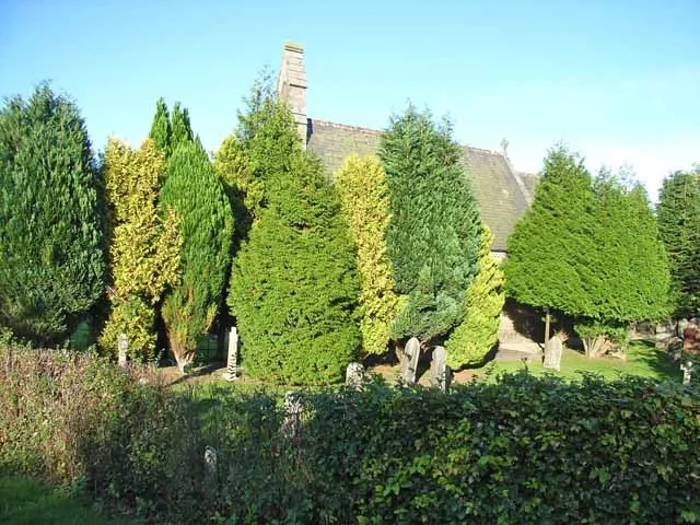
St. Mary Magdalene's Church, Gilsland
Historic churches · 2.5 km

RAF Spadeadam
Other places · 2.5 km

Poltross Burn
Watermills · 3.3 km
Gilsland
Other places · 3.3 km

Mumps Hall
Historic houses · 3.3 km
Nearby
📷 4National parks · North East England
Irthing Gorge
Irthing Gorge in England North East, United Kingdom.
📷 5Waterfalls · North East England
Roseburn Linn Waterfall
Roseburn Linn Waterfall — waterfall in scotland lowlands.
📷 4📷 5Waterfalls · North East England
Gilsland Linn Waterfall
Gilsland Linn Waterfall — waterfall in scotland lowlands.
📷 5Waterfalls · North East England
Chalybeate Linn Waterfall
Chalybeate Linn Waterfall — waterfall in scotland lowlands.
📷 3Historic houses · North East England
Gilsland Spa
Gilsland Spa in England North East, United Kingdom.
Where to eat & stay near Crammel Linn
Places to stay
 📷 5
Campsites · North East England
Chapel house farm walkers campsite
Chapel house farm walkers campsite — a campsite in scotland lowlands.
 📷 5
Hostels · North East England
Greenhead Hostel
Greenhead Hostel — a hostel in scotland lowlands.
 📷 5
Caravan parks · North East England
Blenkinsopp Castle Home Park
Blenkinsopp Castle Home Park — a caravan park in scotland lowlands.
 📷 5
Caravan parks · North East England
Herding Hill Farm Camping
Herding Hill Farm Camping — a caravan park in scotland lowlands.
 📷 5
Campsites · North West England
Camping at Banks
Camping at Banks — a campsite in scotland lowlands.
 📷 5
Hotels · North East England
Centre of Britain
Centre of Britain — a hotel in scotland lowlands.
Places to eat & drink
 📷 4
 📷 4
Historic pubs · North West England
Hallbankgate
Hallbankgate in England North East, United Kingdom.
 📷 5
Historic pubs · North West England
Graham Arms (West Of Gelt Bridge)
Graham Arms (West Of Gelt Bridge) in Scotland Lowlands, United Kingdom.
 📷 5
 📷 7
Historic pubs · North East England
Anchor Hotel
Anchor Hotel in Scotland Lowlands, United Kingdom.
More places in this region
 📷 5
 📷 5
 📷 5
Waterfalls · North East England
Swinner Gill Kirk
Swinner Gill Kirk — waterfall in england north west.
 📷 5
Frequently asked questions
- Where is Crammel Linn?
- Crammel Linn is in North-East England, United Kingdom (postcode CA8 7EW), in the parish of Thirlwall.
- What is Crammel Linn?
- Crammel Linn — waterfall in scotland lowlands.
- How do I get to Crammel Linn?
- The nearest railway station is Haltwhistle, about 8.7 km away. The nearest town is Greenhead. Drivers can use postcode CA8 7EW.
- Is Crammel Linn a protected site?
- Yes — Crammel Linn is part of the Irthing Gorge SSSI Site of Special Scientific Interest and the Kielder Mires SSSI Site of Special Scientific Interest.
- How do I get to Crammel Linn?
- Drivers can navigate to postcode CA8 7EW. It sits within the Hexham parliamentary constituency.