
Beaches · South East England
Colwell Bay
In or near Brook.
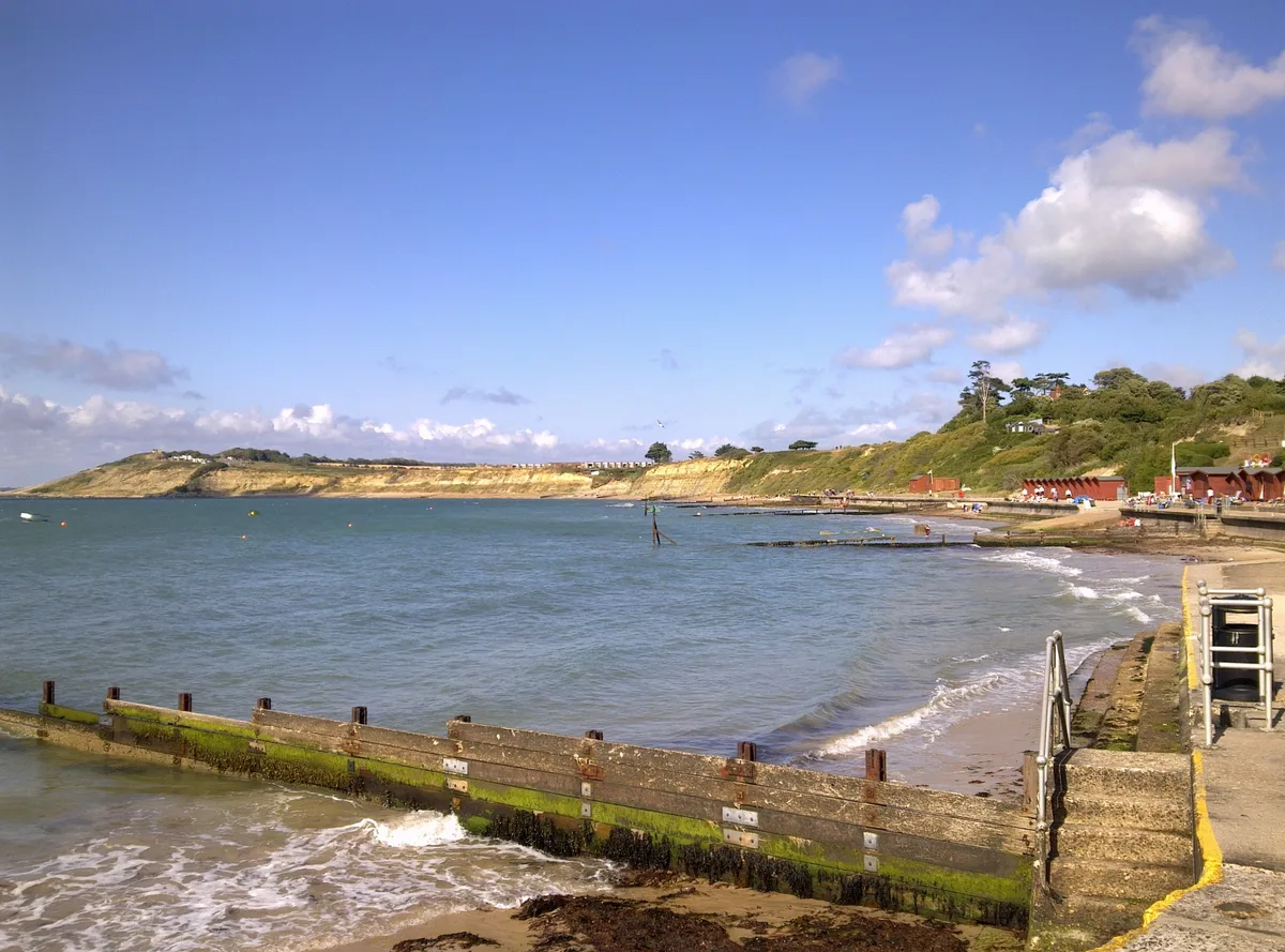
Colwell Bay is a beach in the United Kingdom.

David Smith — CC BY-SA 2.0 via Wikimedia Commons licence

Plan your visit
- Typical visit
- 1 h–3 h
- Best time of year
- Summer (Jun–Aug)
- Nearest railway station
- Lymington Pier · 7.1 km
- Free entry
- Family-friendly
- Dog-friendly
Getting there & planning your visit
Colwell Bay is located in the Isle of Wight, with the nearest railway station being Lymington Pier, which is 7.1 km away. Entry to the beach is free.
About
Colwell Bay is a beach on the coast of South-East England. The site is within the Isle Of Wight National Landscape (AONB), and is a designated Site of Special Scientific Interest. It sits within the Isle of Wight West parliamentary constituency. The nearest railway station is Lymington Pier, about 7.1 km away. Postcode area PO40.
Photo gallery
Official information
Colwell Bay is a picturesque beach located on the north-west coast of the Isle of Wight, known for its clear waters and sandy shoreline, making it ideal for swimming. The beach features amenities such as beach huts, cafes, and a bar, along with stunning views of the Solent and nearby landmarks like Hurst Castle.
Protected designations
- Site of Special Scientific Interest: Colwell Bay SSSI
- Area of Outstanding Natural Beauty: Isle Of Wight
Designations sourced from Natural England open data under OGL v3.
From the Wikipedia article
Colwell Bay (grid reference SZ323873) is a bay in the west of the Isle of Wight. It is located between the towns of Totland and Yarmouth. The bay's northernmost point is Cliff's End (Fort Albert) the closest point of the Island to the British mainland, with Hurst Castle situated at the end of a long peninsula just under a mile (1500 metres) to the northwest. The bay's southern boundary is marked by Warden Point. Colwell Bay has a popular beach, with two miles of sand and shingle, and facilities including cafes, shops and equipment hire outlets. An area of 33.5 acres (13.56 ha) has been notified as a geological Site of Special Scientific Interest, notification originally taking place in 1959. The site is significant for its Eocene geology and maritime vegetated soft cliff habitat. It is the location of three chines: Colwell Chine, Brambles Chine and Linstone Chine. Colwell Bay is on the A3054 road and near the western end of the A3055 road. Public transport to the area is provided by Southern Vectis route 7 and the Needles Tour.
Excerpt from Wikipedia under CC BY-SA 4.0. See the source article linked in Sources below.
- Coordinates
- 50.6942, -1.5348
- District
- Isle of Wight
- Parish
- Freshwater
- Postcode
- PO40 9SZ
- Parliamentary constituency
- Isle of Wight West
- Nearest railway station
- Lymington Pier — 7.1 km
- Official site
- www.visitisleofwight.co.uk
Sources
- osm: w836077455 (ODbL)
- wikipedia: Colwell Bay (CC BY-SA 4.0)
Other places nearby

Heathfield Farm Camp Site
Campsites · 0.7 km

Fort Ruins
Forts · 0.8 km
Fort Ruins
Forts · 0.9 km

Fort Ruins
Forts · 1.0 km

Golden Hill Fort
Forts · 1.1 km

Golden Hill Fort
Hill forts · 1.1 km

West Wight Heritage Centre
Museums · 1.2 km
Colwell Bay
Mountains & hills · 1.3 km

Fort Victoria Model Railway
Forts · 1.6 km

Fort Victoria Country Park
Museums · 1.7 km
Fort Victoria
Castles · 1.7 km

Fort Victoria
Castles · 1.7 km
Nearby
📷 5Campsites · South East England
Heathfield Farm Camp Site
Heathfield Farm Camp Site — a campsite in england south east.
📷 5📷 5📷 5📷 5📷 5Hill forts · South East England
Golden Hill Fort
Golden Hill Fort — a other in england-south-east, United Kingdom.
Where to eat & stay near Colwell Bay
Places to stay
📷 5Campsites · South East England
Heathfield Farm Camp Site
Heathfield Farm Camp Site — a campsite in england south east.
 📷 5
📷 5 📷 7
📷 7 📷 5
📷 5Hotels · South East England
Farringford House
Farringford House — a hotel in england south east.
 📷 5
📷 5 📷 7
📷 7Hotels · South East England
The George Hotel
The George Hotel — a hotel in england south east.
Places to eat & drink
 📷 7
📷 7 📷 5
📷 5Historic pubs · South East England
The Beach House
The Beach House in England South East, United Kingdom.
 📷 7
📷 7 📷 7
📷 7Historic pubs · South East England
Walhampton Arms, formerly farm building range at Home Farm
Walhampton Arms, formerly farm building range at Home Farm in England South East, United Kingdom.
 📷 7
📷 7 📷 7
📷 7Historic pubs · South East England
The Hobler Public House
The Hobler Public House in England South East, United Kingdom.
More beaches in this region
 📷 5
📷 5Beaches · South East England
Abbot's Cliff Beach
Abbot's Cliff Beach is a beach in the United Kingdom.
 📷 5
📷 5Beaches · South East England
Allhallows Beach
Allhallows Beach is a beach in the United Kingdom.
 📷 5
📷 5 📷 5
📷 5Frequently asked questions
- Where is Colwell Bay?
- Colwell Bay is in South-East England, United Kingdom (postcode PO40 9SZ), in the parish of Freshwater.
- What is Colwell Bay?
- Colwell Bay is a beach in the United Kingdom.
- How do I get to Colwell Bay?
- The nearest railway station is Lymington Pier, about 7.1 km away. Drivers can use postcode PO40 9SZ.
- Is Colwell Bay a protected site?
- Yes — Colwell Bay is part of the Colwell Bay SSSI Site of Special Scientific Interest and the Isle Of Wight National Landscape (AONB).
- Is Colwell Bay free to visit?
- Yes, Colwell Bay is free to enter.
- How do I get to Colwell Bay?
- The nearest railway station is Lymington Pier, about 7.1 km away. Drivers can navigate to postcode PO40 9SZ.