
Mountains & hills · South West England
Charfield Hill
In or near Falfield.
Charfield Hill — mountain in england west midlands. Elevation: 86 m.

Jaggery — CC BY-SA 2.0 via Wikimedia Commons licence

Plan your visit
- Typical visit
- 3 h–8 h
- Best time of year
- Late spring – early autumn (May–Oct)
- Nearest railway station
- Yate · 9.7 km
- Dog-friendly
About
Charfield Hill is a mountain located in england west midlands. Elevation: 86 m. A named British peak recorded in OpenStreetMap. Peaks are typically named on Ordnance Survey 1:50k mapping.
Photo gallery
360° view
Imagery © Mapillary contributors, CC BY-SA 4.0
Protected designations
- Area of Outstanding Natural Beauty: Cotswolds
- Ramsar wetland: Severn Estuary
Designations sourced from Natural England open data under OGL v3.
Place summary
Charfield Hill is a mountain located in the West Midlands region of England. It offers a range of outdoor activities, including hiking and nature observation. The area is characterised by its scenic views and varied terrain, making it suitable for both casual walkers and more experienced hikers. Visitors can expect a natural setting ideal for exploring the local flora and fauna.
AI-generated from the structured facts on this page (operator, designation, listing, era). Not a substitute for visiting.
- Coordinates
- 51.6277, -2.4162
- District
- South Gloucestershire
- Parish
- Charfield
- Postcode
- GL12 8LQ
- Parliamentary constituency
- Thornbury and Yate
- Nearest railway station
- Yate — 9.7 km
Sources
- osm: n9911258514 (ODbL)
Other places nearby

Charfield War Memorial
Memorials & monuments · 0.7 km

The Lake
Reservoirs & lochs · 0.7 km
The Lake
Wild swimming spots · 0.7 km

Cullimore's Quarry
Quarries · 1.0 km

Tortworth
Villages · 1.1 km
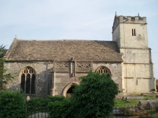
St James' Church, Charfield
Historic churches · 1.2 km

Tortworth Chestnut
Natural landmarks · 1.4 km

Tortworth Court Hotel
Hotels · 2.0 km

Damery Old Castle
Castles · 2.3 km

Damery camp
Literary houses · 2.3 km

Small multivallate hillfort 660m east of Whitfield Farm
Vineyards · 2.4 km

Bloody Acre Hill Fort
Hill forts · 2.4 km
Nearby
📷 3Memorials & monuments · South West England
Charfield War Memorial
Charfield War Memorial — Grade II listed building-listed memorial in england-west-midlands, United Kingdom.
📷 3Reservoirs & lochs · South West England
The Lake
The Lake — a other in england-west-midlands, United Kingdom.
📷 5Wild swimming spots · South West England
The Lake
The Lake — a wild swimming in england west midlands.
📷 3Quarries · South West England
Cullimore's Quarry
Cullimore's Quarry — Site of Special Scientific Interest in South Gloucestershire.
📷 5📷 3Historic churches · South West England
St James' Church, Charfield
St James' Church, Charfield — church in Charfield, South Gloucestershire, England, UK.
Where to eat & stay near Charfield Hill
Places to stay
📷 5Hotels · South West England
Tortworth Court Hotel
Tortworth Court Hotel — a hotel in england west midlands.
 📷 5
📷 5Hotels · South West England
Swan Hotel
Swan Hotel — a hotel in england west midlands.
 📷 5
📷 5Campsites · South West England
Conygres Scout Campsite
Conygres Scout Campsite — a campsite in england west midlands.
 📷 5📷 5
Campsites · South West England
Hogsdown Farm
Hogsdown Farm — a campsite in england west midlands.
 📷 5
📷 5Campsites · South West England
Little Wood Caravan Park
Little Wood Caravan Park — a campsite in england south east.
Places to eat & drink
 📷 7
📷 7 📷 5
📷 5 📷 7
📷 7 📷 5
📷 5Historic pubs · South West England
Ancient Ram Inn
Ancient Ram Inn in England South West, United Kingdom.
 📷 5
📷 5Historic pubs · South West England
The Salutation Inn
The Salutation Inn in England South West, United Kingdom.
 📷 5
📷 5More mountains in this region
 📷 5
📷 5 📷 5
📷 5 📷 5
📷 5 📷 5
📷 5Frequently asked questions
- Where is Charfield Hill?
- Charfield Hill is in the West Midlands, United Kingdom (postcode GL12 8LQ), in the parish of Charfield.
- What is Charfield Hill?
- Charfield Hill — mountain in england west midlands. Elevation: 86 m.
- How do I get to Charfield Hill?
- The nearest railway station is Yate, about 9.7 km away. Drivers can use postcode GL12 8LQ.
- Is Charfield Hill a protected site?
- Yes — Charfield Hill is part of the Cotswolds National Landscape (AONB) and the Severn Estuary Ramsar wetland.
- How do I get to Charfield Hill?
- Drivers can navigate to postcode GL12 8LQ. It sits within the Thornbury and Yate parliamentary constituency.