Mountains & hills · North West England
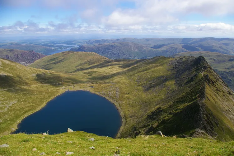
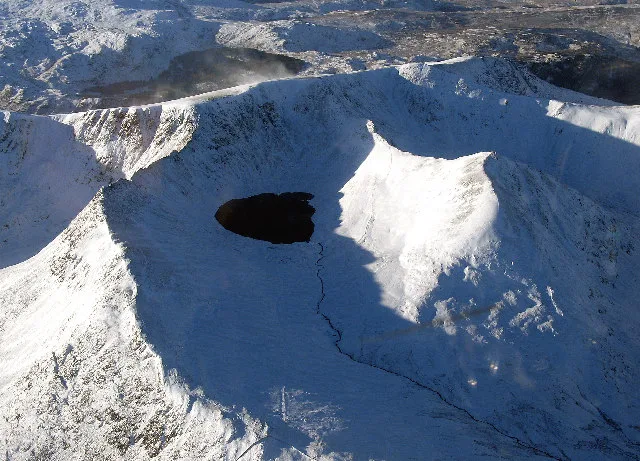
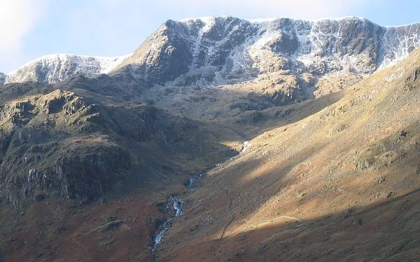
Catstycam
In or near Patterdale.
Catstycam — Named summit at 889.6 m.

Wikimedia Commons contributors — see linked file page for photographer and licence licence
Plan your visit
- Typical visit
- 3 h–8 h
- Best time of year
- Late spring – early autumn (May–Oct)
- Nearest railway station
- Threlkeld Quarry · 8.7 km
- Free entry
- Dog-friendly
About
Catstycam is a named summit in the United Kingdom. Wikidata describes it as: "Named summit at 889.6 m.". Coordinates: 54.5335°, -3.0089°.
Photo gallery
360° viewimagery from 2022
Imagery © Mapillary contributors, CC BY-SA 4.0
Protected designations
- Site of Special Scientific Interest: River Derwent and Tributaries SSSI
- Site of Special Scientific Interest: Helvellyn & Fairfield SSSI
- Site of Special Scientific Interest: River Eden and Tributaries SSSI
Designations sourced from Natural England open data under OGL v3.
From the Wikipedia article
Catstye Cam is a fell in the English Lake District. It is an outlier of Helvellyn in the Eastern Fells.
Excerpt from Wikipedia under CC BY-SA 4.0. See the source article linked in Sources below.
- Coordinates
- 54.5335, -3.0089
- Address
- Cumbria, England
- Nearest railway station
- Threlkeld Quarry — 8.7 km
Sources
- osm: n5375763184 (ODbL)
- wikipedia: Catstye Cam (CC BY-SA 4.0)
- commons: Catstye Cam from Helvellyn.jpg (CC BY-SA 4.0)
Other places nearby

Catstye Cam
Mountains & hills · 0.0 km
Red Tarn
Natural landmarks · 0.6 km

Helvellyn
Natural landmarks · 0.8 km
Helvellyn
Mountains & hills · 0.9 km

Avro 585 Gosport Plane Landing plaque
Memorials & monuments · 0.9 km

Lower Man
Mountains & hills · 1.1 km

White Side
Mountains & hills · 1.3 km
White Side
Natural landmarks · 1.4 km

Birkhouse Moor
Mountains & hills · 1.5 km
Birkhouse Moor
Natural landmarks · 1.6 km
Nethermost Pike
Mountains & hills · 1.7 km
Raise
Mountains & hills · 1.7 km
Nearby
📷 5Mountains & hills · North West England
Catstye Cam
Catstye Cam — a hill or mountain in england north east.
📷 3Natural landmarks · North West England
Red Tarn
Red Tarn — lake on Helvellyn, Cumbria, United Kingdom.
📷 3Natural landmarks · North West England
Helvellyn
Helvellyn — mountain in the English Lake District.
📷 3📷 3Memorials & monuments · North West England
Avro 585 Gosport Plane Landing plaque
Avro 585 Gosport Plane Landing plaque — a memorial in england-north-east, United Kingdom.
📷 5Mountains & hills · North West England
Lower Man
Lower Man — mountain in england north east. Elevation: 924.5 m.
Where to eat & stay near Catstycam
Places to stay
 📷 5
📷 5Hostels · North West England
Bury Jubilee Outdoor Pursuits Centre
Bury Jubilee Outdoor Pursuits Centre — a hostel in england north east.
📷 5Hostels · North West England
YHA Helvellyn
YHA Helvellyn — a hostel in england north east. Brand: Youth Hostels Association.
 📷 5
📷 5Caravan parks · North West England
Gillside Caravan Park
Gillside Caravan Park — a caravan park in england north east.
 📷 5
📷 5Campsites · North West England
Gillside Camping
Gillside Camping — a campsite in england north east.
 📷 5
📷 5Campsites · North West England
Thirlspot Farm Camping
Thirlspot Farm Camping — a campsite in england north east.
 📷 7
📷 7Places to eat & drink
 📷 7
📷 7Historic pubs · North West England
The Travellers Rest
The Travellers Rest in England North West, United Kingdom.
 📷 7
📷 7Cafés · North West England
Grange Bridge Cottage
Grange Bridge Cottage — a café in england north east.
 📷 5
📷 5 📷 5
📷 5Historic pubs · North West England
Golden Rule Hotel
Golden Rule Hotel in England North West, United Kingdom.
 📷 5
📷 5Restaurants · North West England
Holbeck Ghyll Restaurant
Holbeck Ghyll Restaurant — a restaurant in england north west.
 📷 4
📷 4Restaurants · North West England
Holbeck Ghyll
Holbeck Ghyll is a restaurant located in Windermere, Cumbria, England. "The late 19th century building was once Lord Lonsdale's hunting lodge and only became a hotel in the 1970s. It won a Michelin st
More mountains in this region
 📷 5
📷 5Mountains & hills · North West England
Appleton Park
Appleton Park — a hill or mountain in england west midlands.
 📷 5
📷 5Mountains & hills · North West England
High Warren
High Warren — mountain in england west midlands. Elevation: 105 m.
 📷 5
📷 5Mountains & hills · North West England
Alderley Edge
Alderley Edge — mountain in england west midlands. Elevation: 194 m.
 📷 3
📷 3Frequently asked questions
- Where is Catstycam?
- Catstycam is in North-East England, United Kingdom.
- What is Catstycam?
- Catstycam — Named summit at 889.6 m.
- How do I get to Catstycam?
- The nearest railway station is Threlkeld Quarry, about 8.7 km away. Its coordinates are 54.5335°, -3.0089°.
- Is Catstycam a protected site?
- Yes — Catstycam is part of the River Derwent and Tributaries SSSI Site of Special Scientific Interest and the Helvellyn & Fairfield SSSI Site of Special Scientific Interest.
- Is Catstycam free to visit?
- Yes, Catstycam is free to enter.