
Mountains & hills · Yorkshire & the Humber
Calver Hill
In or near Arkle Town.
Calver Hill — Named summit at 493 m.

Wikimedia Commons contributors — see linked file page for photographer and licence licence

Plan your visit
- Typical visit
- 3 h–8 h
- Best time of year
- Late spring – early autumn (May–Oct)
- Nearest railway station
- Redmire · 9.4 km
- Free entry
- Dog-friendly
Getting there & planning your visit
To visit Calver Hill, the nearest railway station is Redmire, located 9.4 km away. Entry is free, and the postcode for sat-nav is DL11 6UW.
About
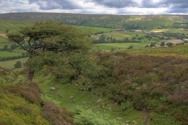
Calver Hill is a named summit in the United Kingdom. Wikidata describes it as: "Named summit at 493 m.". Coordinates: 54.3982°, -1.9809°.
Photo gallery
Protected designations
- Site of Special Scientific Interest: Arkengarthdale, Gunnerside and Reeth Moors SSSI
Designations sourced from Natural England open data under OGL v3.
From the Wikipedia article
Calver Hill is a fell in the Yorkshire Dales National Park in North Yorkshire, England. It is composed of limestone and is situated at grid reference NZ012003, near where the valleys of Swaledale and Arkengarthdale meet, the village of Reeth is located on its lower south-eastern slopes, it reaches an altitude of 487 metres (1,598 ft) and is a distinguished feature in mid Swaledale. Calver Hill is an area of grouse shooting and the fell is dotted with grouse butts. Most of the drainage from the fell goes north and easterly to join the Arkle Beck in lower Arkengarthdale which eventually joins the River Swale just south of Reeth.
Excerpt from Wikipedia under CC BY-SA 4.0. See the source article linked in Sources below.
Background
History
Evidence exits on the slopes of Calver Hill that point to use during the Neolithic Period and the Bronze Age. Finds of arrowheads, flints, and field patterns also point to possible areas of habitation. The whole area of Calver Hill is sometimes referred to as Reeth Low Moor, and in some older texts, the name of the hill is recorded as either Mount Calvey, or Calvey Hill. Another alternative name of Mount Calva persists into the modern day. to the right of the picture and Fremington Edge beyond]] Older versions of the 1:25,000 Ordnance Survey map show a trig point at the summit of Calver Hill but all there is now is a pile of rubble and mining spoil to form a summit cairn. The fell is…
Sourced from Wikipedia under CC BY-SA 4.0.
- Coordinates
- 54.3982, -1.9809
- District
- North Yorkshire
- Parish
- Reeth, Fremington and Healaugh
- Postcode
- DL11 6UW
- Parliamentary constituency
- Richmond and Northallerton
- Nearest railway station
- Redmire — 9.4 km
Sources
- osm: n492907681 (ODbL)
- wikipedia: Calver Hill (CC BY-SA 4.0)
- commons: Calver Hill from Fremington Edge.jpg (CC BY-SA 4.0)
Other places nearby

Prostrate Cross
Memorials & monuments · 0.0 km

Barney Beck High Bridge
Historic bridges · 1.4 km

Scabba Wath Campsite
Campsites · 2.0 km

Scabba Wath Bridge
Historic bridges · 2.1 km

Booze
Historic pubs · 2.2 km

Arkle Town
Towns & cities · 2.2 km

Peat Store
Historic houses · 2.2 km

Low Row Bunk Barn
Hostels · 2.3 km
Maiden Castle
Hill forts · 2.4 km

Langthwaite
National parks · 2.4 km

Low Eskeleth
Villages · 2.4 km

Fremington Edge
National parks · 2.4 km
Nearby
📷 3Memorials & monuments · Yorkshire & the Humber
Prostrate Cross
Prostrate Cross — a memorial in england-yorkshire, United Kingdom.
📷 3Historic bridges · Yorkshire & the Humber
Barney Beck High Bridge
Barney Beck High Bridge — Grade II listed building-listed bridge in england-yorkshire, United Kingdom.
📷 5Campsites · Yorkshire & the Humber
Scabba Wath Campsite
Scabba Wath Campsite — a campsite in england yorkshire.
📷 3Historic bridges · Yorkshire & the Humber
Scabba Wath Bridge
Scabba Wath Bridge — Grade II listed building-listed bridge in england-yorkshire, United Kingdom.
📷 5📷 4Where to eat & stay near Calver Hill
Places to stay
📷 5Campsites · Yorkshire & the Humber
Scabba Wath Campsite
Scabba Wath Campsite — a campsite in england yorkshire.
📷 5 📷 5
📷 5Hotels · Yorkshire & the Humber
The Kings Arms
The Kings Arms — a hotel in england yorkshire.
 📷 5
📷 5 📷 5
📷 5Campsites · Yorkshire & the Humber
Orchard Caravan And Camping Park
Orchard Caravan And Camping Park — a campsite in england yorkshire.
 📷 5
📷 5Hotels · Yorkshire & the Humber
The Punch Bowl
The Punch Bowl — a hotel in england north west.
Places to eat & drink
📷 5 📷 5
📷 5Historic pubs · Yorkshire & the Humber
Kings Head Inn
Kings Head Inn in England North West, United Kingdom.
 📷 5
📷 5Historic pubs · North East England
Milbank Arms
Milbank Arms in England North East, United Kingdom.
 📷 7
📷 7Historic pubs · Yorkshire & the Humber
Fox And Hounds Inn
Fox And Hounds Inn in England Yorkshire, United Kingdom.
 📷 5
📷 5 📷 7
📷 7Cafés · Yorkshire & the Humber
Kim's Cafe & Bistro
Kim's Cafe & Bistro — a café in england yorkshire.
More mountains in this region
 📷 3
📷 3 📷 5
📷 5Mountains & hills · Yorkshire & the Humber
Whaley Moor
Whaley Moor — a hill or mountain in england west midlands.
 📷 5
📷 5Mountains & hills · Yorkshire & the Humber
Idle Hill
Idle Hill — a hill or mountain in england west midlands.
 📷 5
📷 5Mountains & hills · Yorkshire & the Humber
Hollingworthhall Moor
Hollingworthhall Moor — a hill or mountain in england west midlands.
Frequently asked questions
- Where is Calver Hill?
- Calver Hill is in Yorkshire, United Kingdom (postcode DL11 6UW), in the parish of Reeth, Fremington and Healaugh.
- What is Calver Hill?
- Calver Hill — Named summit at 493 m.
- How do I get to Calver Hill?
- The nearest railway station is Redmire, about 9.4 km away. Drivers can use postcode DL11 6UW.
- Is Calver Hill a protected site?
- Yes — Calver Hill is part of the Arkengarthdale, Gunnerside and Reeth Moors SSSI Site of Special Scientific Interest.
- Is Calver Hill free to visit?
- Yes, Calver Hill is free to enter.
- How do I get to Calver Hill?
- Drivers can navigate to postcode DL11 6UW. It sits within the Richmond and Northallerton parliamentary constituency.