
Museums · South East England
Bramdean
In or near Cheriton.
Bramdean is a village and former civil parish, now in the parish of Bramdean and Hinton Ampner, in the Winchester district, in the county of Hampshire, England. It is a linear settlement located along

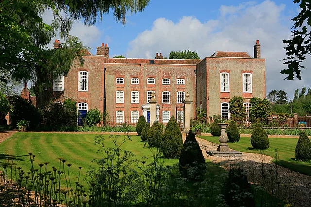
Peter Facey — CC BY-SA 2.0 via Wikimedia Commons licence

Plan your visit
- Typical visit
- 1.5 h–3 h
- Best time of year
- Year-round
- Nearest railway station
- Ropley · 5.6 km
- Family-friendly
- Limited wheelchair access
Getting there & planning your visit
To visit Bramdean, the nearest railway station is Ropley, located 5.6 km away. The postcode for sat-nav is SO24 0LF. Accessibility is limited for wheelchair users.
About
Bramdean is a village and former civil parish, now in the parish of Bramdean and Hinton Ampner, in the Winchester district, in the county of Hampshire, England. It is a linear settlement located along the busy A272 trunk road which was widened by the American troops in 1943 in preparation for D-Day. The village itself is peculiar due to the large number of large houses dating from the Georgian period. A few of these are set in or near beautiful rolling parkland with specimen trees. A number of hamlets are also situated within the boundaries of the parish. To the north of the village is Bramdean Common, known for its good walks and pretty cottages. Further settlements include Little London, Hinton Woodlands, Hells Bottom (or Wolfhanger), and Joans Acre.
Photo gallery
From the Wikipedia article
Bramdean is a village and former civil parish, now in the parish of Bramdean and Hinton Ampner, in the Winchester district, in the county of Hampshire, England. It is a linear settlement located along the busy A272 trunk road which was widened by the American troops in 1943 in preparation for D-Day. The village itself is peculiar due to the large number of large houses dating from the Georgian period. A few of these are set in or near beautiful rolling parkland with specimen trees. A number of hamlets are also situated within the boundaries of the parish. To the north of the village is Bramdean Common, known for its good walks and pretty cottages. Further settlements include Little London, Hinton Woodlands, Hells Bottom (or Wolfhanger), and Joans Acre.
Excerpt from Wikipedia under CC BY-SA 4.0. See the source article linked in Sources below.
Background
History
There are a number of prehistoric barrows in the vicinity of the parish, especially around Brockwood Park, suggesting a significant area of activity for Early Bronze Age peoples. In 1823 a Roman villa was discovered in the parish containing two tesselated pavements of very fine qualities. The villa stood on the site of an older Iron Age enclosure. The village church is dedicated to St Simon and St Jude. It is supposed to have its origins in the 1170s. However, only some of the original 12th-century structure survives, as the church was heavily altered in the 19th century. The original section of the building, consisting of a nave and chancel, is externally rendered, whilst the 19th century…
Description
The Church in the Wood is a chapel which was built to serve the nearby farm workers by the Reverend Alfred Caesar Bishop in 1883 (see Bramdean Common). It was erected in five weeks, and has a timber frame on brick plinth, encased in corrugated iron.
Sourced from Wikipedia under CC BY-SA 4.0.
- Coordinates
- 51.0400, -1.1300
- County
- Hampshire
- District
- Winchester
- Parish
- Bramdean and Hinton Ampner
- Postcode
- SO24 0LF
- Parliamentary constituency
- Winchester
- Nearest railway station
- Ropley — 5.6 km
Sources
- wikipedia: Bramdean (CC BY-SA 4.0)
Other places nearby

The Fox Inn
Historic pubs · 0.9 km

Bramdean House
Manor houses · 1.0 km

Itchen Way
Military museums · 1.3 km

Church of All Saints
Historic churches · 1.4 km

Hinton Ampner Place
Historic houses · 1.4 km

Woodcote Manor House
Manor houses · 1.5 km
Woodcote Manor
Manor houses · 1.5 km

Hinton Ampner
Natural landmarks · 1.5 km

Melksham
Memorials & monuments · 1.9 km
Kilmeston Manor
Stately homes · 2.1 km

Kilmeston
Villages · 2.2 km
'_-_cropped.jpg?width=1200)
Battle of Cheriton
Forts · 2.4 km
Nearby
📷 7📷 5Manor houses · South East England
Bramdean House
Bramdean House — a manor in england-south-east, United Kingdom.
📷 5Military museums · South East England
Itchen Way
Itchen Way — a military museum in england south east.
📷 5Historic churches · South East England
Church of All Saints
Church of All Saints — church in Hinton Ampner, Hampshire, England, UK.
📷 5Historic houses · South East England
Hinton Ampner Place
Hinton Ampner Place — house in Hinton Ampner, Hampshire, England, UK.
📷 5Manor houses · South East England
Woodcote Manor House
Woodcote Manor House — a manor in england-south-east, United Kingdom.
Where to eat & stay near Bramdean
Places to stay
 📷 5
📷 5Campsites · South East England
College Down Farm
College Down Farm — a campsite in england south east.
 📷 5
📷 5Caravan parks · South East England
Brocklands Farm
Brocklands Farm — a caravan park in england south east.
 📷 5
📷 5Campsites · South East England
Watercress Lodges and Campsite
Watercress Lodges and Campsite — a campsite in england south east.
 📷 7
📷 7Hotels · South East England
The Swan Hotel
The Swan Hotel — a hotel in england south east.
 📷 7
📷 7 📷 7
📷 7Places to eat & drink
📷 7 📷 7
📷 7Historic pubs · South East England
The Flowerpots Inn
The Flowerpots Inn in England South East, United Kingdom.
 📷 7
📷 7Historic pubs · South East England
The George And Falcon Inn
The George And Falcon Inn in England South East, United Kingdom.
 📷 5
📷 5 📷 7
📷 7Historic pubs · South East England
Horse And Groom
Horse And Groom in England South East, United Kingdom.
 📷 7
📷 7Historic pubs · South East England
The Running Horse Public House
The Running Horse Public House in England South East, United Kingdom.
More museums in this region
 📷 5
📷 5Museums · South East England
Coldrum Long Barrow
Coldrum Long Barrow — neolithic chambered long barrow near Trottiscliffe, Kent, England, UK.
 📷 5
📷 5Museums · South East England
Guildford House
Guildford House — house in Guildford, Surrey, England, UK.
 📷 5
📷 5Museums · South East England
Huguenot Museum
Huguenot Museum — museum in Rochester, England, UK.
 📷 5
📷 5Museums · South East England
Medway megaliths
Medway megaliths — group of long barrows in Kent, England.
Frequently asked questions
- Where is Bramdean?
- Bramdean is in Hampshire, South-East England, United Kingdom (postcode SO24 0LF), in the parish of Bramdean and Hinton Ampner.
- What is Bramdean?
- Bramdean is a village and former civil parish, now in the parish of Bramdean and Hinton Ampner, in the Winchester district, in the county of Hampshire, England. It is a linear settlement located along
- How do I get to Bramdean?
- The nearest railway station is Ropley, about 5.6 km away. Drivers can use postcode SO24 0LF.
- How do I get to Bramdean?
- The nearest railway station is Ropley, about 5.6 km away. Drivers can navigate to postcode SO24 0LF.