
Historic bridges · Yorkshire & the Humber
Boothferry Bridge
In or near Laxton.
Boothferry Bridge is a historic bridge in the United Kingdom.

Wikimedia Commons contributors — see linked file page for photographer and licence licence

Plan your visit
- Typical visit
- 15 min–30 min
- Nearest railway station
- Goole · 2.7 km
- Paid entry
- Dog-friendly
Getting there & planning your visit
To visit Boothferry Bridge, the nearest railway station is Goole, located 2.7 km away. Entry to the bridge is paid, and accessibility details are not provided. The postcode for sat-nav is DN14 7EE.
About
Boothferry Bridge is a named historic bridge in the United Kingdom. Coordinates: 53.7274°, -0.8902°. This entry is part of The Great Britain Guide, a free, ad-free, open-data tourist directory.
Photo gallery
See it from the streetimagery from 2023
Imagery © Mapillary contributors, CC BY-SA 4.0
Protected designations
- Site of Special Scientific Interest: Humber Estuary - 2000480 SSSI
- Ramsar wetland: Humber Estuary
Designations sourced from Natural England open data under OGL v3.
From the Wikipedia article
Boothferry Bridge is a crossing over the River Ouse, in the East Riding, England, some 2 miles (3.2 km) north-west of Goole. The bridge was opened in 1929, replacing a ferry crossing immediately west of the bridge's location. The act of Parliament for the building of the bridge, the Boothferry Bridge Act 1925, gave priority to river traffic. This situation still exists, though there have been some attempts to change priorities. On opening, it was the furthest crossing downstream of the river, cutting 25 miles (40 km) off the journey south to London from Kingston upon Hull. The M62 Ouse Bridge opened up to the east of Boothferry Bridge in 1976.
Excerpt from Wikipedia under CC BY-SA 4.0. See the source article linked in Sources below.
Background
History
The bridge at Boothferry was built to replace the ferry which connected the hamlet of Booth with the south side of the Ouse. The ferry was owned by the Bishops of Durham and Ripon, having been in operation since at least 1513, but was leased to several operators before the bridge was built. An act of Parliament, the (15 & 16 Geo. 5. c. cxi) was granted providing authority to construct the bridge and giving priority to river traffic. An attempt was made in the 1980s to rescind the priority for river traffic. Before that, the furthest bridge downstream on the River Ouse was Selby toll bridge, some 8 mi upstream of the Boothferry Bridge. Opening of the bridge eased the pressure on the…
Sourced from Wikipedia under CC BY-SA 4.0.
- Coordinates
- 53.7274, -0.8902
- District
- East Riding of Yorkshire
- Parish
- Asselby
- Postcode
- DN14 7EE
- Parliamentary constituency
- Goole and Pocklington
- Nearest railway station
- Goole — 2.7 km
- Opening
- July 1929
Sources
- osm: w1360320962 (ODbL)
- wikipedia: Boothferry Bridge (CC BY-SA 4.0)
- commons: Boothferry Bridge - geograph.org.uk - 555611.jpg (CC BY-SA 4.0)
Other places nearby

Ouse Bridge
Historic bridges · 0.8 km

River Aire
Museums · 1.1 km

Knedlington
Villages · 1.7 km
.jpg?width=1200)
Hook Island
Forests & woodlands · 1.8 km
West Park
Country parks · 1.9 km

Howden Cemetery
Cemeteries · 2.0 km

St Paul's Players
Theatres · 2.2 km

The Cenotaph
Memorials & monuments · 2.3 km

Goole Cenotaph
Memorials & monuments · 2.3 km

Windmill Tower At Number 145 (Timm And Son Ltd)
Windmills · 2.4 km

Percy Jeeves
Memorials & monuments · 2.4 km

Howden Bishop's Manor House
Archaeological sites · 2.5 km
Nearby
📷 5Historic bridges · Yorkshire & the Humber
Ouse Bridge
Ouse Bridge is a historic bridge in the United Kingdom.
📷 5Museums · Yorkshire & the Humber
River Aire
River Aire — a museum in england-yorkshire, United Kingdom.
📷 5📷 3Forests & woodlands · Yorkshire & the Humber
Hook Island
Hook Island is a forest or woodland in the United Kingdom.
📷 3Country parks · Yorkshire & the Humber
West Park
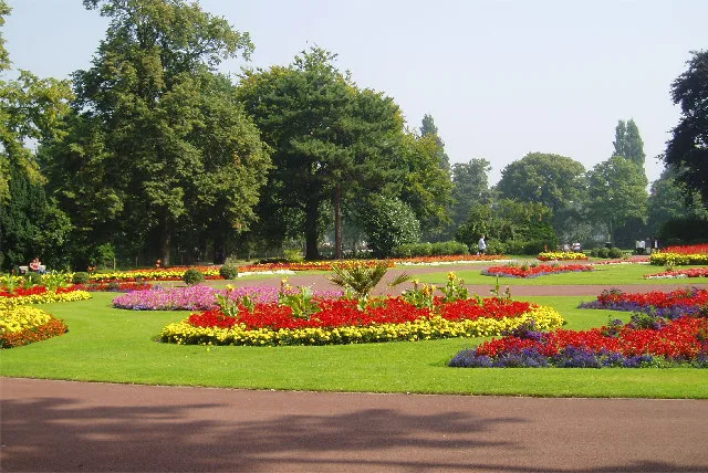
West Park — park in Goole, East Riding of Yorkshire, England, UK.
📷 5Cemeteries · Yorkshire & the Humber
Howden Cemetery
Howden Cemetery is a cemetery in the United Kingdom.
Where to eat & stay near Boothferry Bridge
Places to stay
 📷 5
📷 5Caravan parks · Yorkshire & the Humber
Brenda House Touring Caravan Park
Brenda House Touring Caravan Park — a caravan park in england yorkshire.
 📷 5
📷 5Campsites · Yorkshire & the Humber
Dobella Lane Farm Camping
Dobella Lane Farm Camping — a campsite in england yorkshire.
 📷 5
📷 5Campsites · Yorkshire & the Humber
Whitgift Hall Caravan Site and Fishery
Whitgift Hall Caravan Site and Fishery — a campsite in england yorkshire.
 📷 5
📷 5Caravan parks · Yorkshire & the Humber
Cliffe Meadows Holiday Park
Cliffe Meadows Holiday Park — a caravan park in england yorkshire.
 📷 5
📷 5Caravan parks · Yorkshire & the Humber
Ranch Caravan Park
Ranch Caravan Park — a caravan park in england yorkshire.
 📷 5
📷 5Caravan parks · Yorkshire & the Humber
New Holland Country Park
New Holland Country Park — a caravan park in england yorkshire.
Places to eat & drink
 📷 4
📷 4Historic pubs · Yorkshire & the Humber
The Royal
The Royal — Historic pub — listed building or notable heritage status.
 📷 7
📷 7Restaurants · Yorkshire & the Humber
The Lowther Hotel
The Lowther Hotel — a restaurant in england yorkshire.
 📷 7
📷 7Historic pubs · Yorkshire & the Humber
The Plough Inn
The Plough Inn in England Yorkshire, United Kingdom.
 📷 5
📷 5Historic pubs · Yorkshire & the Humber
The Blacksmith Arms
The Blacksmith Arms in England Yorkshire, United Kingdom.
 📷 7
📷 7Historic pubs · Yorkshire & the Humber
Fox And Coney Public House
Fox And Coney Public House in England Yorkshire, United Kingdom.
 📷 7
📷 7Historic pubs · Yorkshire & the Humber
The Berkeley
The Berkeley in England Yorkshire, United Kingdom.
More bridges in this region
 📷 5
📷 5Historic bridges · Yorkshire & the Humber
Broadbottom Viaduct
Broadbottom Viaduct is a historic bridge in the United Kingdom.
 📷 3
📷 3Historic bridges · Yorkshire & the Humber
Goyt Cliff Viaduct
Goyt Cliff Viaduct is a historic bridge in the United Kingdom.
 📷 3
📷 3Historic bridges · Yorkshire & the Humber
Iron Bridge
Iron Bridge is a historic bridge in the United Kingdom.
.jpg?width=1200) 📷 5
📷 5Historic bridges · Yorkshire & the Humber
Marple Aqueduct
Marple Aqueduct is a historic bridge in the United Kingdom.
Frequently asked questions
- Where is Boothferry Bridge?
- Boothferry Bridge is in Yorkshire, United Kingdom (postcode DN14 7EE), in the parish of Asselby.
- What is Boothferry Bridge?
- Boothferry Bridge is a historic bridge in the United Kingdom.
- How do I get to Boothferry Bridge?
- The nearest railway station is Goole, about 2.7 km away. The nearest town is Laxton. Drivers can use postcode DN14 7EE.
- Who owns Boothferry Bridge?
- Boothferry Bridge is owned by | maint =.
- Is Boothferry Bridge a protected site?
- Yes — Boothferry Bridge is part of the Humber Estuary - 2000480 SSSI Site of Special Scientific Interest and the Humber Estuary Ramsar wetland.
- How do I get to Boothferry Bridge?
- The nearest railway station is Goole, about 2.7 km away. Drivers can navigate to postcode DN14 7EE.