
Natural landmarks · East Midlands
Bleaklow
In or near Old Glossop.
Bleaklow — mountain in Derbyshire, England, UK.

Wikimedia Commons contributors — see linked file page for photographer and licence licence

Plan your visit
- Typical visit
- 1 h–2 h
- Nearest railway station
- Manor Station · 5.3 km
- Free entry
- Family-friendly
- Dog-friendly
Getting there & planning your visit
To visit Bleaklow, the nearest railway station is Manor Station, located 5.3 km away. Entry to the site is free.
About
Bleaklow is a named natural landmark in the United Kingdom. Wikidata describes it as: "mountain in Derbyshire, England, UK". Coordinates: 53.4600°, -1.8626°.
Photo gallery
360° viewimagery from 2022
Imagery © Mapillary contributors, CC BY-SA 4.0
Protected designations
- Site of Special Scientific Interest: Dark Peak SSSI
Designations sourced from Natural England open data under OGL v3.
From the Wikipedia article
Bleaklow is a high, largely peat-covered, gritstone moorland in the Derbyshire High Peak near the town of Glossop. It is north of Kinder Scout, across the Snake Pass (A57), and south of the A628 Woodhead Pass. Much of it is nearly 2,000 feet (610 m) above sea level and the shallow bowl of Swains Greave on its eastern side is the source of the River Derwent. Bleaklow Head (633 m), marked by a large cairn of stones, the high point at the western side of the moor, is a Hewitt and is crossed by the Pennine Way. It is one of three summits on this plateau above 2,000 feet, the others being Bleaklow Stones, some 1.9 miles (3.1 km) to the east along an indefinite ridge, and Higher Shelf Stones, 0.9 miles (1.4 km) south of Bleaklow Head. At 633 metres (2,077 feet), Bleaklow is the second-highest point in Derbyshire and the area includes the most easterly point in the British Isles over 2,000 feet, near Bleaklow Stones.
Excerpt from Wikipedia under CC BY-SA 4.0. See the source article linked in Sources below.
Background
Description
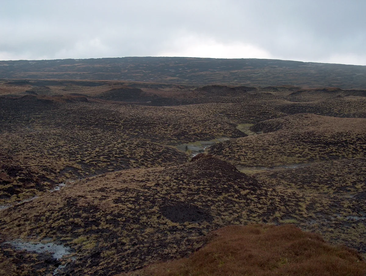
Much of the main plateau of Bleaklow is a boggy peat moorland, seamed by 'groughs' (pronounced 'gruffs', water-eroded channels in the peat) and lacking strong changes in elevation – in poor conditions its traverse is probably the most navigationally challenging in the Peak District.
Sourced from Wikipedia under CC BY-SA 4.0.
- Coordinates
- 53.4600, -1.8626
- Address
- Derbyshire, England, UK
- Nearest railway station
- Manor Station — 5.3 km
Sources
- wikidata: Q883307 (CC0)
- wikipedia: Bleaklow (CC BY-SA 4.0)
- commons: Looking east over Bleaklow - geograph.org.uk - 1745454.jpg (CC BY-SA 4.0)
Other places nearby

Wain Stones
Natural landmarks · 0.0 km

Bleaklow Hill
Mountains & hills · 0.2 km
Bleaklow Head
Mountains & hills · 0.3 km

Hern Stones
Natural landmarks · 0.6 km

B29 Superfortress memorial
Memorials & monuments · 1.0 km

Higher Shelf Stones
Mountains & hills · 1.2 km

Blenheim L1476 memorial
Memorials & monuments · 1.4 km

James's Thorn
Mountains & hills · 1.6 km

Torside Castle
Castles · 1.7 km

Avro Lancaster KB993 and USAAF C-47 Skytrain 42-108982 memorial
Memorials & monuments · 1.7 km

Bleaklow Stones
Mountains & hills · 2.3 km

Woodhead Reservoir
Reservoirs & lochs · 2.6 km
Nearby
📷 3Natural landmarks · East Midlands
Wain Stones
Wain Stones — a other in england-east-midlands, United Kingdom.
📷 5Mountains & hills · East Midlands
Bleaklow Hill
Bleaklow Hill — a hill or mountain in england east midlands.
📷 5📷 3Natural landmarks · East Midlands
Hern Stones
Hern Stones — a other in england-east-midlands, United Kingdom.
📷 3Memorials & monuments · East Midlands
B29 Superfortress memorial
B29 Superfortress memorial — a memorial in england-east-midlands, United Kingdom.
📷 5Mountains & hills · East Midlands
Higher Shelf Stones
Higher Shelf Stones — mountain in england east midlands. Elevation: 621.5 m.
Where to eat & stay near Bleaklow
Places to stay
 📷 5
📷 5Campsites · East Midlands
Crowden Campsite
Crowden Campsite — a campsite in england east midlands.
 📷 5
📷 5Hostels · East Midlands
Crowden Outdoor Education Centre
Crowden Outdoor Education Centre — a hostel in england east midlands.
 📷 5
📷 5Caravan parks · East Midlands
Windy Harbour Hotel Caravan and Camping Site
Windy Harbour Hotel Caravan and Camping Site — a caravan park in england east midlands.
 📷 5
📷 5Campsites · East Midlands
Crossgate Farm Campsite
Crossgate Farm Campsite — a campsite in england east midlands.
 📷 5
📷 5 📷 5
📷 5Campsites · East Midlands
Hayfield Campsite
Hayfield Campsite — a campsite in england east midlands.
Places to eat & drink
 📷 5
📷 5Historic pubs · East Midlands
Bulls Head Public House
Bulls Head Public House in England Yorkshire, United Kingdom.
 📷 5
📷 5Historic pubs · East Midlands
Norfolk Arms Public House
Norfolk Arms Public House in England Yorkshire, United Kingdom.
 📷 5
📷 5Historic pubs · East Midlands
Former Dollars Public House
Former Dollars Public House in England Yorkshire, United Kingdom.
 📷 5
📷 5Historic pubs · East Midlands
The Oakwood and Oakwood Restaurant
The Oakwood and Oakwood Restaurant in England Yorkshire, United Kingdom.
 📷 5
📷 5Historic pubs · East Midlands
The Crown Inn, Glossop
The Crown Inn, Glossop in England Yorkshire, United Kingdom.
 📷 7
📷 7Historic pubs · East Midlands
The Spinners Arms Public House
The Spinners Arms Public House in England Yorkshire, United Kingdom.
More natural landmarks in this region
 📷 5
📷 5Natural landmarks · East Midlands
The Cage
The Cage — a other in england-london, United Kingdom.
 📷 5
📷 5Natural landmarks · East Midlands
Roman Sea Bank
Roman Sea Bank — a other in england-london, United Kingdom.
 📷 5
📷 5Natural landmarks · East Midlands
The Stamford Spa
The Stamford Spa — a other in england-london, United Kingdom.
 📷 5
📷 5Natural landmarks · East Midlands
John Clare's grave
John Clare's grave — a other in england-london, United Kingdom.
Frequently asked questions
- Where is Bleaklow?
- Bleaklow is in the East Midlands, United Kingdom.
- What is Bleaklow?
- Bleaklow — mountain in Derbyshire, England, UK.
- How do I get to Bleaklow?
- The nearest railway station is Manor Station, about 5.3 km away. Its coordinates are 53.4600°, -1.8626°.
- Is Bleaklow a protected site?
- Yes — Bleaklow is part of the Dark Peak SSSI Site of Special Scientific Interest.
- Is Bleaklow free to visit?
- Yes, Bleaklow is free to enter.
- How do I get to Bleaklow?
- The nearest railway station is Manor Station, about 5.3 km away.