
Natural landmarks · East Midlands
The Cage
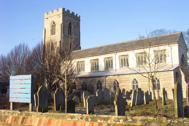
The Cage — a other in england-london, United Kingdom.

Bob Harvey — CC BY-SA 2.0 via Wikimedia Commons licence

Plan your visit
- Typical visit
- 1 h–2 h
- Free entry
- Family-friendly
- Dog-friendly
About
The Cage is a other located in england-london, United Kingdom. Sourced from OpenStreetMap (ODbL licence); see local listings for visitor information, opening hours and admission details.
Photo gallery
Heritage listing
Details SJ 98 SE LYME HANDLEY C.P. LYME PARK 4/73 The Cage. 14/4/1967 II* Formerly hunting tower cum gatehouse, later park keeper's house and prisoners' lock-up: Origins c.1580, taken down 1734 by George Platt, rebuilt 1737 by Peter Platt, perhaps to a design by Leoni for Peter Legh X. Coursed, squared, buff sandstone rubble with ashlar sandstone dressings, felted roof and cupolas (originally stone) and formerly 2 chimneys. In plan, square with attached square corner towers. 3-storeys symmetrical fronts. Chamfered plinth, raised rusticated quoins, applied ashlar band at first floor. Windows in towers in raised, plain surrounds (now blocked but with 12-pane sashes originally). Semi-circular headed doorcases on 3 faces, with rusticated surrounds and Tuscan pilaster capitals to imposts with raised plain, window surrounds above (all blocked). Projecting heavily-moulded entablature with ashlar blocking course with central balustrading (probably added by Wyatt, now damaged). On towers, stepped bases to domed cupolas (now C20 wooden replacements) 3 square sundials on moulded sills between 1st and 2nd storeys, read: east face, "Vive Hodie"; south face, "Remember now the creator in the days of thy youth"; west face, "Cras minus aptus eris". Interior: 4 Tuscan antae with banded rustication in ground floor. Diagonal flight leads to spiral, stone staircase in south-west corner tower. Remainder of interior now removed but first floor was the main room with a panelled oak ceiling with huge, central, carved rosette. The stairs were in one corner, a fireplace, a lavatory, and a prison room in the others. All the elements used in the rebuild can be found in the south and west ranges of Lyme Park (q.v.) but it is not certain if the C16 structure (paralled by an example at Chatsworth) was
From the Historic England List Entry under OGL v3.
Place summary
The Cage is a historical structure located in London. It is known for its distinctive architecture and serves as a notable example of the area's past. Further details regarding its era or specific significance are not provided.
AI-generated from the structured facts on this page (operator, designation, listing, era). Not a substitute for visiting.
- Coordinates
- 52.6561, 0.0240
- County
- Cambridgeshire
- District
- Fenland
- Parish
- Parson Drove
- Postcode
- PE13 4HA
- Parliamentary constituency
- North East Cambridgeshire
Sources
- osm: node/313305546 (ODbL)
Other places nearby
Parson Drove War Memorial
Memorials & monuments · 0.1 km

Bridge And Sluices
Historic bridges · 1.0 km

Museum of Technology
Museums · 1.2 km

War Memorial, Railings and Gate
Memorials & monuments · 1.5 km

Murrow
Villages · 1.5 km

The Museum of Technology
Museums · 1.9 km
Throckenholt
Museums · 1.9 km
St John the Baptist's Church
Historic churches · 2.1 km

Gedney Hill
Historic churches · 2.8 km

Common Right Barns
Caravan parks · 3.5 km

Rosebay Camping (naturist)
Campsites · 4.2 km

Gedney Hill
Villages · 4.3 km
Nearby
📷 5Memorials & monuments · East Midlands
Parson Drove War Memorial
Parson Drove War Memorial — Grade II listed building-listed memorial in england-london, United Kingdom.
📷 5Historic bridges · East Midlands
Bridge And Sluices
Bridge And Sluices — Grade II listed building-listed bridge in england-london, United Kingdom.
📷 5Museums · East Midlands
Museum of Technology
Museum of Technology — a museum in england-london, United Kingdom.
📷 5Memorials & monuments · East Midlands
War Memorial, Railings and Gate
War Memorial, Railings and Gate — Grade II listed building-listed memorial in england-london, United Kingdom.
📷 5📷 5Museums · East Midlands
The Museum of Technology
The Museum of Technology — a museum in england-london, United Kingdom.
Where to eat & stay near The Cage
Places to stay
📷 5Caravan parks · East Midlands
Common Right Barns
Common Right Barns — a caravan park in england london.
📷 5Campsites · East Midlands
Rosebay Camping (naturist)
Rosebay Camping (naturist) — a campsite in england london.
 📷 5
📷 5Caravan parks · East Midlands
Tall Trees Leisure Park
Tall Trees Leisure Park — a caravan park in england london.
 📷 4
📷 4Campsites · East Midlands
The Secret Garden Touring Park
The Secret Garden Touring Park — a campsite in england london.
 📷 5
📷 5Caravan parks · East Midlands
Inglescombe Touring Park
Inglescombe Touring Park — a caravan park in england london.
 📷 3
📷 3Campsites · East Midlands
Hawthorne Farm Wisbech
Hawthorne Farm Wisbech — a campsite in england east midlands.
Places to eat & drink
 📷 5
📷 5 📷 5
📷 5 📷 5
📷 5 📷 5
📷 5Historic pubs · East of England
Sportsman Public House
Sportsman Public House in England East, United Kingdom.
 📷 5
📷 5Historic pubs · East Midlands
The George And Angel Public House
The George And Angel Public House in England East, United Kingdom.
 📷 5
📷 5Historic pubs · East Midlands
Number 18, Formerly The Cock And Magpie Public House
Number 18, Formerly The Cock And Magpie Public House in England East, United Kingdom.
More natural landmarks in this region
 📷 5
📷 5Natural landmarks · East Midlands
Roman Sea Bank
Roman Sea Bank — a other in england-london, United Kingdom.
 📷 5
📷 5Natural landmarks · East Midlands
The Stamford Spa
The Stamford Spa — a other in england-london, United Kingdom.
 📷 5
📷 5Natural landmarks · East Midlands
John Clare's grave
John Clare's grave — a other in england-london, United Kingdom.
 📷 5
📷 5Natural landmarks · East Midlands
John Clare Cottage
John Clare Cottage — a other in england-london, United Kingdom.
Frequently asked questions
- Where is The Cage?
- The Cage is in Cambridgeshire, London, United Kingdom (postcode PE13 4HA), in the parish of Parson Drove.
- What is The Cage?
- The Cage — a other in england-london, United Kingdom.
- How do I get to The Cage?
- Drivers can use postcode PE13 4HA.
- Is The Cage a listed building?
- The Cage is officially recognised as Grade II* listed building listed.
- Is The Cage free to visit?
- Yes, The Cage is free to enter.
- How do I get to The Cage?
- Drivers can navigate to postcode PE13 4HA. It sits within the North East Cambridgeshire parliamentary constituency.