
Historic houses · North East England
Bitchfield Tower
In or near Bolam.
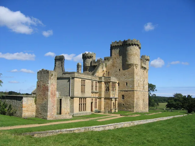
Bitchfield Tower — house in Belsay, Northumberland, England, UK.

Wikimedia Commons contributors — see linked file page for photographer and licence licence

Plan your visit
- Typical visit
- 1 h–2 h
- Family-friendly
- Limited wheelchair access
About
Bitchfield Tower is a historic house in the United Kingdom — typically a country seat, manor, or town house with notable architecture or history. Heritage designation: Grade I listed building. Wikidata describes it as: "house in Belsay, Northumberland, England, UK". Coordinates: 55.0879°, -1.8593°.
Photo gallery
Protected designations
- Site of Special Scientific Interest: Northumberland Shore SSSI
Designations sourced from Natural England open data under OGL v3.
From the Wikipedia article
Bitchfield Tower or West Bitchfield Tower is a medieval pele tower near Belsay, Northumberland, England. It is a Grade I listed building. The three storied battlemented tower was built in the 15th century by the Middleton family who sold it to the Harbottles in 1502. Marjorie Harbottle the heiress to the Harbottle estate, married Sir John Fenwick of Fenwick Tower and in 1529 they conveyed the property to their second son Roger Fenwick. In 1622 Robert Fenwick built a new manor house adjoining the tower: a datestone inscribed 'RF 1622 JF' is incorporated into the building The Fenwicks sold the estate in 1630 to Edward Grey, from whom it was sequestered in 1646. In 1680 it was acquired by Sir James Clavering and in 1802 the Claverings sold to Sir Charles Monck. It was in a state of ruin by 1930 but has since been restored. The east wing was added by the architect Caroë and Lord Gort in 1935. The tower was listed on 27 August, 1952.
Excerpt from Wikipedia under CC BY-SA 4.0. See the source article linked in Sources below.
- Coordinates
- 55.0879, -1.8593
- District
- Northumberland
- Parish
- Belsay
- Postcode
- NE20 0JP
- Parliamentary constituency
- Hexham
Sources
- wikidata: Q4918785 (CC0)
- wikipedia: Bitchfield Tower (CC BY-SA 4.0)
- commons: Bitchfield Pele Tower.jpg (CC BY-SA 4.0)
Other places nearby

Belsay Hall
Castles · 1.4 km

Blackheddon Farmhouse
Literary houses · 1.6 km

Black Heddon
Other places · 1.7 km
Belsay Castle
Castles · 1.7 km

Bantam Hill
Vineyards · 1.8 km

Belsay
Manor houses · 1.9 km

Bridge Approx 440 Yds North-East Of Belsay Castle
Historic bridges · 1.9 km

Bridge Approx 350 Yards North Of Belsay Castle
Historic bridges · 1.9 km

Bridge And Gateway Approx 750 Yards West Of Belsay Castle
Historic bridges · 2.0 km

Harnham
Villages · 2.0 km

Standing stone on Bygate Hill, 660m north west of Bygate Farm
Windmills · 2.4 km

Milbourne
Historic churches · 3.3 km
Nearby
📷 5Castles · North East England
Belsay Hall
Belsay Hall in England North East, United Kingdom.
📷 5Literary houses · North East England
Blackheddon Farmhouse
Blackheddon Farmhouse — a literary house museum in scotland lowlands.
📷 4📷 3Castles · North East England
Belsay Castle
Belsay Castle — medieval castle ruins in Northumberland, England, UK.
📷 5Vineyards · North East England
Bantam Hill
Bantam Hill — a UK vineyard in scotland lowlands, producing English or Welsh wine from cool-climate grape varieties.
📷 5Manor houses · North East England
Belsay
Belsay in England North East, United Kingdom.
Where to eat & stay near Bitchfield Tower
Places to stay
 📷 5
📷 5Campsites · North East England
Tranwell Farm Camp Site
Tranwell Farm Camp Site — a campsite in scotland lowlands.
 📷 5
📷 5Hotels · North East England
DoubleTree by Hilton Newcastle International Airport
DoubleTree by Hilton Newcastle International Airport — a hotel in scotland lowlands. 4-star. Brand: DoubleTree.
 📷 5
📷 5 📷 5
📷 5Caravan parks · North East England
Wellhouse Farm Caravan Park
Wellhouse Farm Caravan Park — a caravan park in scotland lowlands.
📷 5Campsites · North East England
Wellhouse Farm Camping site
Wellhouse Farm Camping site — a campsite in scotland lowlands.
 📷 5
📷 5Places to eat & drink
 📷 5
📷 5 📷 5
📷 5Historic pubs · North East England
The Seven Stars Public House
The Seven Stars Public House in Scotland Lowlands, United Kingdom.
 📷 5
📷 5Historic pubs · North East England
The Crown And Anchor
The Crown And Anchor in Scotland Lowlands, United Kingdom.
 📷 5
📷 5 📷 5
📷 5 📷 3
📷 3Historic pubs · North East England
Red House Farm
Red House Farm in England North East, United Kingdom.
More historic houses in this region
 📷 3
📷 3Historic houses · North East England
Wayside cross known as Jenny Bradley 1000m north west of Bloworth Crossing on Greenhow Moor
Wayside cross known as Jenny Bradley 1000m north west of Bloworth Crossing on Greenhow Moor — a Grade II-listed historic house in england-yorkshire, United Kingdom.
 📷 3
📷 3Historic houses · North East England
Crackpot Hall
Crackpot Hall — a historic house in North East England, United Kingdom.
 📷 3
📷 3Historic houses · North East England
Bunton Mine shop
Bunton Mine shop — a historic house in North East England, United Kingdom.
 📷 3
📷 3Historic houses · North East England
Blakethwaite Mine
Blakethwaite Mine — a historic house in North East England, United Kingdom.
Frequently asked questions
- Where is Bitchfield Tower?
- Bitchfield Tower is in North-East England, United Kingdom (postcode NE20 0JP), in the parish of Belsay.
- What is Bitchfield Tower?
- Bitchfield Tower — house in Belsay, Northumberland, England, UK.
- How do I get to Bitchfield Tower?
- The nearest town is Bolam. Drivers can use postcode NE20 0JP.
- Is Bitchfield Tower a listed building?
- Bitchfield Tower is officially recognised as Grade I listed building listed.
- Is Bitchfield Tower a protected site?
- Yes — Bitchfield Tower is part of the Northumberland Shore SSSI Site of Special Scientific Interest.
- How do I get to Bitchfield Tower?
- Drivers can navigate to postcode NE20 0JP. It sits within the Hexham parliamentary constituency.