
Museums · West Midlands
Bewdley
In or near Areley Kings.
Bewdley ( BEWD-lee) is a town and civil parish in the Wyre Forest District in Worcestershire, England, on the banks of the River Severn. It is in the Severn Valley, and is 3+1⁄2 miles (5.5 kilometres

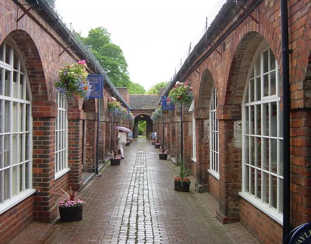
Stephen McKay — CC BY-SA 2.0 via Wikimedia Commons licence

Plan your visit
- Typical visit
- 1.5 h–3 h
- Best time of year
- Year-round
- Nearest railway station
- Bewdley · 0.6 km
- Free entry
- Family-friendly
- Wheelchair accessible
Getting there & planning your visit
To visit Bewdley Museum, the nearest railway station is Bewdley, located 0.6 km away. Entry to the museum is free, and it is wheelchair accessible. The postcode for sat-nav is DY12 2AE.
About
Bewdley ( BEWD-lee) is a town and civil parish in the Wyre Forest District in Worcestershire, England, on the banks of the River Severn. It is in the Severn Valley, and is 3+1⁄2 miles (5.5 kilometres) west of Kidderminster, 12+1⁄2 mi (20 km) north of Worcester and 23 mi (37 km) southwest of Birmingham. It lies on the River Severn, at the gateway of the Wyre Forest national nature reserve, and at the time of the 2021 census had a population of 9,267. Bewdley is a popular tourist destination and is known for the Bewdley Bridge, designed by Thomas Telford, and the well-preserved Georgian riverside.
Photo gallery
See it from the streetimagery from 2025
Imagery © Mapillary contributors, CC BY-SA 4.0
Official information
Bewdley Museum showcases the history and heritage of the riverside town of Bewdley through interactive displays and sensory experiences. Visitors can explore various exhibits, including local history and crafts, and even experience what it was like to be incarcerated in the town's jails.
Protected designations
- Site of Special Scientific Interest: River Teme SSSI
Designations sourced from Natural England open data under OGL v3.
From the Wikipedia article
Bewdley ( BEWD-lee) is a town and civil parish in the Wyre Forest District in Worcestershire, England, on the banks of the River Severn. It is in the Severn Valley, and is 3+1⁄2 miles (5.5 kilometres) west of Kidderminster, 12+1⁄2 mi (20 km) north of Worcester and 23 mi (37 km) southwest of Birmingham. It lies on the River Severn, at the gateway of the Wyre Forest national nature reserve, and at the time of the 2021 census had a population of 9,267. Bewdley is a popular tourist destination and is known for the Bewdley Bridge, designed by Thomas Telford, and the well-preserved Georgian riverside.
Excerpt from Wikipedia under CC BY-SA 4.0. See the source article linked in Sources below.
Background
History
]] Mesolithic-period settlers have been identified through excavations in Wribbenhall, which found 1,400 fragments of flint tools, as well as post holes, a hearth, gullies and a pit. This site has been dated to roughly 6,800 BC, making it the oldest settlement yet identified in Worcestershire. Pollen evidence shows that crops were already being grown and woodlands cleared at this time. The main part of Bewdley town is situated on the western bank of the River Severn, including the main street—Load Street. Its name derives from lode, an old word for ferry. Load Street is notable for its width: it once also served as the town's market place. Most of Bewdley's shops and amenities are situated…
Sourced from Wikipedia under CC BY-SA 4.0.
- Coordinates
- 52.3758, -2.3150
- County
- Worcestershire
- District
- Wyre Forest
- Parish
- Bewdley
- Postcode
- DY12 2AE
- Parliamentary constituency
- Wyre Forest
- Phone
- 0845 607 7819
- Nearest railway station
- Bewdley — 0.6 km
- Opening
- Daily 10am–4.30pm; closed 24–26 Dec
- Official site
- www.bewdleymuseum.co.uk
Sources
- wikipedia: Bewdley (CC BY-SA 4.0)
Other places nearby
Bewdley Museum
Museums · 0.0 km

Stanley Baldwin
Public art & sculpture · 0.0 km

George Hotel
Hotels · 0.0 km

Cock And Magpie Public House
Historic pubs · 0.1 km

The Clock House
Hostels · 0.1 km

Bewdley Bridge
Historic bridges · 0.1 km
.jpg?width=1200)
Bailiff's House
Historic houses · 0.1 km
The Talbot Inn
Historic pubs · 0.1 km

Quay Side On South Side Of River Severn, Extending South From Severn Bridge For About 290 Metres Including Four Flights Of Steps
Marinas · 0.1 km

Quay Side On North Side Of River Severn, Extending South From Severn Bridge For About 140 Metres And Two Flights Of Steps
Marinas · 0.2 km

Horn And Trumpet Public House
Historic pubs · 0.2 km

Community Orchard
Natural landmarks · 0.2 km
Nearby
📷 3Museums · West Midlands
Bewdley Museum
Bewdley Museum — museum in Bewdley, England, United Kingdom.
📷 4Public art & sculpture · West Midlands
Stanley Baldwin
Stanley Baldwin — a public art in england-west-midlands, United Kingdom.
📷 7Hotels · West Midlands
George Hotel
George Hotel — a hotel in england west midlands.
📷 7Historic pubs · West Midlands
Cock And Magpie Public House
Cock And Magpie Public House in England West Midlands, United Kingdom.
📷 5Hostels · West Midlands
The Clock House
The Clock House — a hostel in england west midlands.
📷 4Historic bridges · West Midlands
Bewdley Bridge
Bewdley Bridge — a Grade I-listed bridge in england-west-midlands, United Kingdom.
Where to eat & stay near Bewdley
Places to stay
📷 7Hotels · West Midlands
George Hotel
George Hotel — a hotel in england west midlands.
📷 5Hostels · West Midlands
The Clock House
The Clock House — a hostel in england west midlands.
 📷 5
📷 5 📷 5
📷 5Campsites · West Midlands
Riverside Caravan Park Bewdley
Riverside Caravan Park Bewdley — a campsite in england west midlands.
 📷 5
📷 5Caravan parks · West Midlands
Blackstone Meadow Holiday Park
Blackstone Meadow Holiday Park — a caravan park in england west midlands.
 📷 5
📷 5Caravan parks · West Midlands
Brant Caravan Park
Brant Caravan Park — a caravan park in england west midlands.
Places to eat & drink
📷 7Historic pubs · West Midlands
Cock And Magpie Public House
Cock And Magpie Public House in England West Midlands, United Kingdom.
📷 7📷 7Historic pubs · West Midlands
Horn And Trumpet Public House
Horn And Trumpet Public House in England West Midlands, United Kingdom.
 📷 5
📷 5Historic pubs · West Midlands
Wood Colliers Arms Public House And Attached Railings
Wood Colliers Arms Public House And Attached Railings in England West Midlands, United Kingdom.
 📷 5
📷 5Historic pubs · West Midlands
The Black Boy Hotel
The Black Boy Hotel — Historic pub — listed building or notable heritage status.
 📷 7
📷 7Historic pubs · West Midlands
Southern Part Of The Red Lion Public House
Southern Part Of The Red Lion Public House in England West Midlands, United Kingdom.
More museums in this region
 📷 3
📷 3Museums · West Midlands
Redfern Cottage
Redfern Cottage — a museum in england-east-midlands, United Kingdom.
 📷 3
📷 3Museums · West Midlands
Museum of Cannock Chase
Museum of Cannock Chase — a museum in england-east-midlands, United Kingdom.
 📷 5
📷 5Museums · West Midlands
Cannock Chase District
Cannock Chase is a designated Area of Outstanding Natural Beauty and National Landscape in Staffordshire, England. It gives its name to Cannock Chase District, a non-metropolitan local government dist
 📷 5
📷 5Museums · West Midlands
Uttoxeter
Uttoxeter — a museum in england-east-midlands, United Kingdom.
Frequently asked questions
- Where is Bewdley?
- Bewdley is in Worcestershire, the West Midlands, United Kingdom (postcode DY12 2AE), in the parish of Bewdley.
- What is Bewdley?
- Bewdley ( BEWD-lee) is a town and civil parish in the Wyre Forest District in Worcestershire, England, on the banks of the River Severn. It is in the Severn Valley, and is 3+1⁄2 miles (5.5 kilometres
- How do I get to Bewdley?
- The nearest railway station is Bewdley, about 0.6 km away. Drivers can use postcode DY12 2AE.
- Is Bewdley a protected site?
- Yes — Bewdley is part of the River Teme SSSI Site of Special Scientific Interest.
- Is Bewdley free to visit?
- Yes, Bewdley is free to enter.
- How do I get to Bewdley?
- The nearest railway station is Bewdley, about 0.6 km away. Drivers can navigate to postcode DY12 2AE.