
Battlefields & battle sites · Northern Ireland
Battle of Carrickfergus
In or near Helen's Bay.
Battle of Carrickfergus in Northern Ireland, United Kingdom.

Eric Jones — CC BY-SA 2.0 via Wikimedia Commons licence

Plan your visit
- Typical visit
- 1 h–2 h
- Nearest railway station
- Carrickfergus · 0.6 km
- Free entry
- Dog-friendly
About
Battle of Carrickfergus is a place of interest in Northern Ireland, United Kingdom — drawn from open-data sources for visitor reference. See the linked Wikipedia article for the full description.
Photo gallery
From the Wikipedia article
The Battle of Carrickfergus took place in November 1597, in the province of Ulster in what is now County Antrim, Northern Ireland, during the Nine Years War. It was fought between the crown forces of Queen Elizabeth I and the Gaelic clan of MacDonnell, with military support from Hugh O'Neill, Earl of Tyrone, and resulted in a defeat for the English.
Excerpt from Wikipedia under CC BY-SA 4.0. See the source article linked in Sources below.
Background
History
The north-east of Ulster was much fought over during the 16th century. Carrickfergus itself had been the base for a failed English attempt to colonise that corner of the province in the 1570s, but in the following decades the English influence gave way to the MacDonnells under the leadership of Sorley Boy. In 1595 the Irish lords in Ulster rose out in rebellion under Hugh O'Neill, and the crown's only foothold in County Antrim was at Carrickfergus, and a small garrison in Belfast Castle. The MacDonnells adopted a wait-and-see policy, without committing themselves fully to the crown in its campaign to break the rebellion, though they facilitated Tyrone's arms shipments out of Scotland,…
Description
]] On the appointed day MacDonnell was sighted by the English on his approach to Carrickfergus Castle at the head of 700 troops. Not wishing to be outdone, the governor came out with the bulk of his men, just five companies of foot - who were wearied from a recent expedition - and one of horse. He led them out four miles, until the Scots were encountered, and then halted to allow his troops to close up on the advanced guard. In the interval the officers debated, one veteran urging the governor to proceed with the parley. But when his troops drew up, the governor turned to his commander, Captain Merriman (correctly Marmion), and said, "Now, Captain, yonder be your old friends. What say you?…
Sourced from Wikipedia under CC BY-SA 4.0.
- Coordinates
- 54.7130, -5.8060
- District
- Mid and East Antrim
- Postcode
- BT38 7BG
- Parliamentary constituency
- East Antrim
- Nearest railway station
- Carrickfergus — 0.6 km
Sources
- wikidata: Q489057 (CC0)
- wikipedia: Battle of Carrickfergus (1597) (CC BY-SA 4.0)
Other places nearby
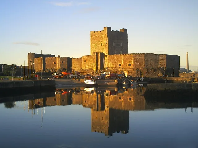
Carrickfergus Castle
Castles · 0.0 km

King William III Monument
Memorials & monuments · 0.1 km

Carrickfergus Lifeboat Station
Natural landmarks · 0.1 km
Carrickfergus
Natural landmarks · 0.1 km

arts
Public art & sculpture · 0.2 km

Lauryn James
Galleries · 0.2 km

Carrickfergus Borough Council Town Hall
Historic houses · 0.3 km
Carrickfergus Museum
Museums · 0.4 km

Carrickfergus Sailing Club
Natural landmarks · 0.4 km

Carrickfergus Harbour
Marinas · 0.4 km

Carrickfergus Omniplex
Theatres · 0.4 km

Omniplex
Cinemas · 0.4 km
Nearby
📷 5Castles · Northern Ireland
Carrickfergus Castle
Carrickfergus Castle is a castle in the United Kingdom.
📷 3Memorials & monuments · Northern Ireland
King William III Monument
King William III Monument — a memorial in northern-ireland, United Kingdom.
📷 4Natural landmarks · Northern Ireland
Carrickfergus Lifeboat Station
Carrickfergus Lifeboat Station in Northern Ireland, United Kingdom.
📷 5Natural landmarks · Northern Ireland
Carrickfergus
Carrickfergus in Northern Ireland, United Kingdom.
📷 3Public art & sculpture · Northern Ireland
arts
arts — a public art in northern-ireland, United Kingdom.
📷 3Galleries · Northern Ireland
Lauryn James
Lauryn James — a gallery in northern-ireland, United Kingdom.
Where to eat & stay near Battle of Carrickfergus
Places to stay
 📷 5
📷 5Caravan parks · Northern Ireland
Jordanstown Loughshore Caravan Park
Jordanstown Loughshore Caravan Park — a caravan park in northern ireland.
 📷 5
📷 5Campsites · Northern Ireland
Lorne Estate
Lorne Estate — a campsite in northern ireland.
 📷 5
📷 5Campsites · Northern Ireland
Crawfordsburn Scout Centre
Crawfordsburn Scout Centre — a campsite in northern ireland.
 📷 5
📷 5 📷 5
📷 5 📷 5
📷 5Hotels · Northern Ireland
The Pink Cottage
The Pink Cottage — a hotel in northern ireland.
Places to eat & drink
 📷 5
📷 5 📷 5
📷 5 📷 7
📷 7Historic pubs · Northern Ireland
Kelly's Cellars
Kelly's Cellars in Northern Ireland, United Kingdom.
 📷 7
📷 7Historic pubs · Northern Ireland
Crown Liquor Saloon
Crown Liquor Saloon in Northern Ireland, United Kingdom.
 📷 3
📷 3Historic pubs · Northern Ireland
Red Lion Pub bombing
Red Lion Pub bombing in Northern Ireland, United Kingdom.
 📷 5
📷 5More places in this region

Battlefields & battle sites · Northern Ireland
Randalstown Forest Nature Reserve
Randalstown Forest Nature Reserve in Northern Ireland, United Kingdom.
 📷 4
📷 4Battlefields & battle sites · Northern Ireland
Bohill Forest
Bohill Forest in Northern Ireland, United Kingdom.
 📷 4
📷 4Battlefields & battle sites · Northern Ireland
Battle of Newry Road
Battle of Newry Road in Northern Ireland, United Kingdom.
 📷 3
📷 3Battlefields & battle sites · Northern Ireland
Battle of the Bogside
Battle of the Bogside in Northern Ireland, United Kingdom.
Frequently asked questions
- Where is Battle of Carrickfergus?
- Battle of Carrickfergus is in Northern Ireland, United Kingdom (postcode BT38 7BG).
- What is Battle of Carrickfergus?
- Battle of Carrickfergus in Northern Ireland, United Kingdom.
- How do I get to Battle of Carrickfergus?
- The nearest railway station is Carrickfergus, about 0.6 km away. Drivers can use postcode BT38 7BG.
- Is Battle of Carrickfergus free to visit?
- Yes, Battle of Carrickfergus is free to enter.
- How do I get to Battle of Carrickfergus?
- The nearest railway station is Carrickfergus, about 0.6 km away. Drivers can navigate to postcode BT38 7BG.