
Museums · North West England
Barnoldswick
In or near East Marton.
Barnoldswick (pronounced ) is a market town and civil parish in the Borough of Pendle, Lancashire, England. It lies within the boundaries of the historic West Riding of Yorkshire. It is situated 30 mi

Roger Templeman — CC BY-SA 2.0 via Wikimedia Commons licence

Plan your visit
- Typical visit
- 1.5 h–3 h
- Best time of year
- Year-round
- Nearest railway station
- Colne · 6.7 km
- Family-friendly
- Limited wheelchair access
Getting there & planning your visit
To visit the museum in Barnoldswick, you can take a train to Colne station, which is 6.7 km away. The postcode for navigation is BB18 5PA. Please note that wheelchair accessibility is limited.
About
Barnoldswick (pronounced ) is a market town and civil parish in the Borough of Pendle, Lancashire, England. It lies within the boundaries of the historic West Riding of Yorkshire. It is situated 30 miles (48 km) from Leeds and 40 miles (64 km) from Lancaster; nearby towns include Skipton to the east, Clitheroe to the west, Burnley to the south and Keighley to the east-south-east. The civil parish has a population of 10,752.
Photo gallery
From the Wikipedia article
Barnoldswick (pronounced ) is a market town and civil parish in the Borough of Pendle, Lancashire, England. It lies within the boundaries of the historic West Riding of Yorkshire. It is situated 30 miles (48 km) from Leeds and 40 miles (64 km) from Lancaster; nearby towns include Skipton to the east, Clitheroe to the west, Burnley to the south and Keighley to the east-south-east. The civil parish has a population of 10,752.
Excerpt from Wikipedia under CC BY-SA 4.0. See the source article linked in Sources below.
Background
History
Barnoldswick dates back to Anglo Saxon times. It was listed in the Domesday Book as Bernulfesuuic, meaning "Bernulf's Town" ( being an archaic spelling of –wick, meaning "settlement", in particular, a "dairy farm"). The town is known locally as Barlick. A Cistercian monastery was founded here in 1147, by monks from Fountains Abbey. However, they left after six years, before construction was complete, driven out by crop failures and locals unhappy at their interference in the affairs of the local church. They went on to build Kirkstall Abbey. They returned after another ten years to build the isolated Church of St Mary-le-Ghyll close to the road between Barnoldswick and Thornton in Craven.…
Sourced from Wikipedia under CC BY-SA 4.0.
- Coordinates
- 53.9147, -2.1895
- County
- Lancashire
- District
- Pendle
- Parish
- Barnoldswick
- Postcode
- BB18 5PA
- Parliamentary constituency
- Pendle and Clitheroe
- Nearest railway station
- Colne — 6.7 km
Sources
- wikipedia: Barnoldswick (CC BY-SA 4.0)
Other places nearby
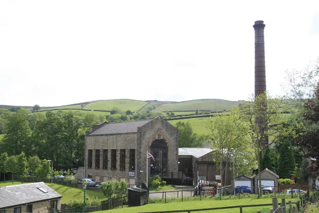
Bancroft Shed
Museums · 0.4 km

Bancroft Mill
Museums · 0.4 km

Stacked Stone Totem
Public art & sculpture · 0.5 km
Wooden Ram
Public art & sculpture · 0.5 km

Man in the ground
Public art & sculpture · 0.6 km
Frog Carving
Public art & sculpture · 0.7 km

Leeds And Liverpool Canal Cockshott Bridge
Historic bridges · 1.0 km

Cockshott Bridge
Historic bridges · 1.0 km

Barlick Castle
Castles · 1.1 km

Coates Hall
Historic houses · 1.2 km

Little Cut
Canals · 1.2 km

Bridge Holme Caravan Site
Campsites · 1.3 km
Nearby
📷 4Museums · North West England
Bancroft Shed
Bancroft Shed — mill museum in Barnoldswick, Pendle, Lancashire, England, UK.
📷 3Museums · North West England
Bancroft Mill
Bancroft Mill — a museum in england-north-west, United Kingdom.
📷 3Public art & sculpture · North West England
Stacked Stone Totem
Stacked Stone Totem — a public art in england-north-west, United Kingdom.
📷 5Public art & sculpture · North West England
Wooden Ram
Wooden Ram — a public art in england-north-west, United Kingdom.
📷 3Public art & sculpture · North West England
Man in the ground
Man in the ground — a public art in england-north-west, United Kingdom.
📷 3Public art & sculpture · North West England
Frog Carving
Frog Carving — a public art in england-north-west, United Kingdom.
Where to eat & stay near Barnoldswick
Places to stay
📷 5Campsites · North West England
Bridge Holme Caravan Site
Bridge Holme Caravan Site — a campsite in england north west.
 📷 5
📷 5Campsites · North West England
Lower Greenhill Holiday Park
Lower Greenhill Holiday Park — a campsite in england north west.
 📷 5
📷 5Hostels · North West England
Earby Friends of Nature House
Earby Friends of Nature House — a hostel in england north west.
📷 5Hostels · North West England
Earby Holiday Hostel
Earby Holiday Hostel — a hostel in england north west.
 📷 5
📷 5Caravan parks · North West England
Holgates Ribble Valley
Holgates Ribble Valley — a caravan park in england north west.
 📷 5
📷 5Caravan parks · North West England
Manor House Farm Caravan Site
Manor House Farm Caravan Site — a caravan park in england north west.
Places to eat & drink
 📷 5
📷 5Historic pubs · North West England
Cross Gaits Inn
Cross Gaits Inn in England North West, United Kingdom.
 📷 7
📷 7Cafés · Yorkshire & the Humber
The Dalesman Cafe, Tea Room and Sweet Emporium
The Dalesman Cafe, Tea Room and Sweet Emporium — a café in england north west.
 📷 5
📷 5Restaurants · North West England
The Spread Eagle
The Spread Eagle — a restaurant in england north west.
 📷 5
📷 5 📷 5
📷 5Restaurants · North West England
Fence Gate Inn
Fence Gate Inn — a restaurant in england north west.
📷 5More museums in this region
 📷 3
📷 3Museums · North West England
Cube Gallery
Cube Gallery — former architecture museum in Manchester, England.
 📷 3
📷 3Museums · North West England
Cuckooland Museum
Cuckooland Museum — horological museum in England, UK.
 📷 4
📷 4Museums · North West England
Elizabeth Gaskell's House
Elizabeth Gaskell's House — museum in Manchester.
 📷 3
📷 3Museums · North West England
Englesea Brook Chapel and Museum of Primitive Methodism
Englesea Brook Chapel and Museum of Primitive Methodism — Primitive Methodist chapel and museum, United Kingdom.
Frequently asked questions
- Where is Barnoldswick?
- Barnoldswick is in Lancashire, North-West England, United Kingdom (postcode BB18 5PA), in the parish of Barnoldswick.
- What is Barnoldswick?
- Barnoldswick (pronounced ) is a market town and civil parish in the Borough of Pendle, Lancashire, England. It lies within the boundaries of the historic West Riding of Yorkshire. It is situated 30 mi
- How do I get to Barnoldswick?
- The nearest railway station is Colne, about 6.7 km away. Drivers can use postcode BB18 5PA.
- How do I get to Barnoldswick?
- The nearest railway station is Colne, about 6.7 km away. Drivers can navigate to postcode BB18 5PA.