
Museums · North West England
Bacup
In or near Cliviger.
Bacup ( BAY-kəp, ) is a town in the Rossendale Borough in Lancashire, England, in the South Pennines close to Lancashire's boundaries with West Yorkshire and Greater Manchester. The town is in the Ros

robert wade — CC BY-SA 2.0 via Wikimedia Commons licence

Plan your visit
- Typical visit
- 1.5 h–3 h
- Best time of year
- Year-round
- Nearest railway station
- Rawtenstall · 6.1 km
- Family-friendly
- Limited wheelchair access
Getting there & planning your visit
To visit Bacup Museum, the nearest railway station is Rawtenstall, located 6.1 km away. The postcode for the museum is OL13 9BA. Please note that wheelchair accessibility is limited.
About
Bacup ( BAY-kəp, ) is a town in the Rossendale Borough in Lancashire, England, in the South Pennines close to Lancashire's boundaries with West Yorkshire and Greater Manchester. The town is in the Rossendale Valley and the upper Irwell Valley, 4 miles (6.4 km) east of Rawtenstall, 6 miles (9.7 km) north of Rochdale, and 7 miles (11 km) south of Burnley. At the 2011 Census, Bacup had a population of 13,323. Bacup emerged as a settlement following the Anglo-Saxon settlement of Britain in the Early Middle Ages. For centuries, it was a small and obscure centre of domestic flannel and woollen cloth production, and many of the original weavers' cottages survive today as listed buildings. Following the Industrial Revolution, Bacup became a mill town, growing up around the now covered over bridge crossing the River Irwell and the north–south / east-west crossroad at its centre. During that time its landscape became dominated by distinctive and large rectangular woollen and cotton mills. Bacup received a charter of incorporation in 1882, giving it municipal borough status and its own elected town government, consisting of a mayor, aldermen and councillors to oversee local affairs. In 1974, Bacup became part of the borough of Rossendale. Bacup's historic character, culture and festivities have encouraged the town to be seen as one of the best preserved mill towns in England. English Heritage has proclaimed Bacup town centre as a designated protected area for its special architectural q
Photo gallery
From the Wikipedia article
Bacup ( BAY-kəp, ) is a town in the Rossendale Borough in Lancashire, England, in the South Pennines close to Lancashire's boundaries with West Yorkshire and Greater Manchester. The town is in the Rossendale Valley and the upper Irwell Valley, 4 miles (6.4 km) east of Rawtenstall, 6 miles (9.7 km) north of Rochdale, and 7 miles (11 km) south of Burnley. At the 2011 Census, Bacup had a population of 13,323. Bacup emerged as a settlement following the Anglo-Saxon settlement of Britain in the Early Middle Ages. For centuries, it was a small and obscure centre of domestic flannel and woollen cloth production, and many of the original weavers' cottages survive today as listed buildings. Following the Industrial Revolution, Bacup became a mill town, growing up around the now covered over bridge crossing the River Irwell and the north–south / east-west crossroad at its centre. During that time its landscape became dominated by distinctive and large rectangular woollen and cotton mills. Bacup received a charter of incorporation in 1882, giving it municipal borough status and its own elected town government, consisting of a mayor, aldermen and councillors to oversee local affairs. In 1974, Bacup became part of the borough of Rossendale. Bacup's historic character, culture and festivities have encouraged the town to be seen as one of the best preserved mill towns in England. English Heritage has proclaimed Bacup town centre as a designated protected area for its special architectural qualities.
Excerpt from Wikipedia under CC BY-SA 4.0. See the source article linked in Sources below.
Background
History
The name Bacup is derived from the Old English fūlbæchop. The Oxford Dictionary of British Place Names translates this as "muddy valley by a ridge"; the fūl- element, which meant "foul" or "muddy" was used in the earliest known reference to the area, in a charter by Robert de Lacey, around the year 1200, as used in the Middle English spelling fulebachope. The -bæchop element is less clear, possibly meaning "ridge valley", Bacup and its hinterland has provided archeological evidence of human activity in the area during the Neolithic. Anglo-Saxons settled in the Early Middle Ages. It has been claimed that in the 10th century the Anglo-Saxons battled against Gaels and Norsemen at Broadclough,…
Sourced from Wikipedia under CC BY-SA 4.0.
- Coordinates
- 53.7040, -2.1990
- County
- Lancashire
- District
- Rossendale
- Parish
- Rossendale, unparished area
- Postcode
- OL13 9BA
- Parliamentary constituency
- Rossendale and Darwen
- Nearest railway station
- Rawtenstall — 6.1 km
Sources
- wikipedia: Bacup (CC BY-SA 4.0)
Other places nearby

Cast Iron Wall To Bridge
Historic bridges · 0.1 km

Bacup War Memorial
Memorials & monuments · 0.2 km
War memorial in the churchyard of St John the Evangelist, Bacup
Memorials & monuments · 0.2 km
_-_geograph.org.uk_-_462467.jpg?width=1200)
Forest House
Historic houses · 0.4 km
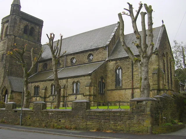
Christ Church, Bacup
Abbeys & priories · 0.5 km

Christ Church, Bacup
Cathedrals · 0.5 km

Royal Court Theatre, Bacup
Theatres · 1.2 km

Kozy Picture House
Theatres · 1.3 km

Broadclough Dykes
Forts · 1.4 km
Old Bridge C10 Metres South-East Of Dog Pits Lane Bridge Over River Irwell
Historic bridges · 1.5 km

Lee Quarry Red Route
Mountain bike trails · 2.2 km

Higher Hogshead
Mountains & hills · 2.3 km
Nearby
📷 3Historic bridges · North West England
Cast Iron Wall To Bridge
Cast Iron Wall To Bridge — Grade II listed building-listed bridge in england-north-west, United Kingdom.
📷 3Memorials & monuments · North West England
Bacup War Memorial
Bacup War Memorial — Grade II listed building-listed memorial in england-north-west, United Kingdom.
📷 3Memorials & monuments · North West England
War memorial in the churchyard of St John the Evangelist, Bacup
War memorial in the churchyard of St John the Evangelist, Bacup — Grade II listed building-listed memorial in england-north-west, United Kingdom.
📷 3Historic houses · North West England
Forest House
Forest House — house in Rossendale, Lancashire, England, UK.
📷 3Abbeys & priories · North West England
Christ Church, Bacup
Christ Church, Bacup — church in Bacup, Lancashire, England, UK.
Flagship📷 4Cathedrals · North West England
Christ Church, Bacup
Christ Church, Bacup is a cathedral in the United Kingdom.
Where to eat & stay near Bacup
Places to stay
 📷 5
📷 5Campsites · North West England
The Paddock Campsite
The Paddock Campsite — a campsite in england north west.
 📷 5
📷 5Hostels · Yorkshire & the Humber
Mankinholes Youth Hostel
Mankinholes Youth Hostel — a hostel in england north west.
 📷 7
📷 7Hotels · North West England
Red Hall Hotel
Red Hall Hotel — a hotel in england north west.
 📷 5
📷 5Hotels · North West England
Broadfield Park Hotel
Broadfield Park Hotel — a hotel in england north west.
 📷 5
📷 5Hotels · North West England
Travelodge
Travelodge — a hotel in england north west.
 📷 5
📷 5Campsites · Yorkshire & the Humber
Height Gate Farm
Height Gate Farm — a campsite in england north west.
Places to eat & drink
 📷 5
📷 5Historic pubs · Yorkshire & the Humber
Weavers Arms Public House
Weavers Arms Public House in England North West, United Kingdom.
 📷 3
📷 3Historic pubs · Yorkshire & the Humber
Queen's Hotel
Queen's Hotel — Historic pub — listed building or notable heritage status.
 📷 5
📷 5 📷 5
📷 5 📷 7
📷 7Historic pubs · North West England
The Baum
The Baum in England North West, United Kingdom.
 📷 5
📷 5More museums in this region
 📷 3
📷 3Museums · North West England
Cube Gallery
Cube Gallery — former architecture museum in Manchester, England.
 📷 3
📷 3Museums · North West England
Cuckooland Museum
Cuckooland Museum — horological museum in England, UK.
 📷 4
📷 4Museums · North West England
Elizabeth Gaskell's House
Elizabeth Gaskell's House — museum in Manchester.
 📷 3
📷 3Museums · North West England
Englesea Brook Chapel and Museum of Primitive Methodism
Englesea Brook Chapel and Museum of Primitive Methodism — Primitive Methodist chapel and museum, United Kingdom.
Frequently asked questions
- Where is Bacup?
- Bacup is in Lancashire, North-West England, United Kingdom (postcode OL13 9BA), in the parish of Rossendale, unparished area.
- What is Bacup?
- Bacup ( BAY-kəp, ) is a town in the Rossendale Borough in Lancashire, England, in the South Pennines close to Lancashire's boundaries with West Yorkshire and Greater Manchester. The town is in the Ros
- How do I get to Bacup?
- The nearest railway station is Rawtenstall, about 6.1 km away. Drivers can use postcode OL13 9BA.
- How do I get to Bacup?
- The nearest railway station is Rawtenstall, about 6.1 km away. Drivers can navigate to postcode OL13 9BA.