
Towns & cities · East Midlands
Youlgrave
Also known as: Youlgreave
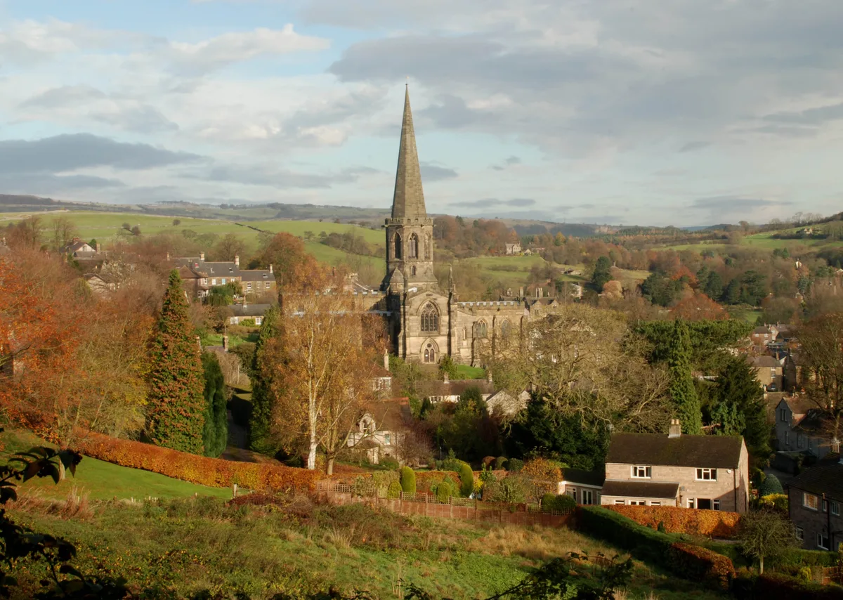
Youlgrave — village and civil parish in Derbyshire Dales district, Derbyshire, England.
.jpg?width=1200)
Wikimedia Commons contributors — see linked file page for photographer and licence licence
.jpg)
Plan your visit
- Typical visit
- 3 h–6 h
- Nearest railway station
- Rowsley South · 5.2 km
- Free entry
- Family-friendly
- Dog-friendly
Getting there & planning your visit
Youlgrave is located in the East Midlands, Derbyshire, with the nearest railway station being Rowsley South, approximately 5.2 km away. Admission to the town is free.
About
Youlgrave is a town, city, village or settlement in the United Kingdom. It covers approximately 4 km². Recent population estimates put it at around 1,018 people. Address: DE45. Wikidata describes it as: "village and civil parish in Derbyshire Dales district, Derbyshire, England". Coordinates: 53.1750°, -1.6870°.
Photo gallery
Protected designations
- Site of Special Scientific Interest: Lathkill Dale SSSI
Designations sourced from Natural England open data under OGL v3.
From the Wikipedia article
Youlgreave or Youlgrave is a village and civil parish in the Peak District of Derbyshire, England, on the River Bradford 2+1⁄2 miles (4.0 km) south of Bakewell. The name possibly derives from "yellow grove", the ore mined locally being yellow in colour. The population in 1991 was 1,256; it is one of the largest villages in the Peak District National Park. The village has three public houses (the George Hotel, Farmyard Inn and Bull's Head Hotel), and a British Legion club.
Excerpt from Wikipedia under CC BY-SA 4.0. See the source article linked in Sources below.
Background
History
Youlgreave was mentioned in the Domesday Book as belonging to Henry de Ferrers and being worth sixteen shillings. All Saints' Church, Youlgreave, has a 12th-century font. The main round bowl is carved with decorative motifs, and it has a second small bowl, supported by a salamander corbel. The font was moved to Youlgreave in the 19th century, from the church at Elton. The building is grade I listed. There are also a number of historic buildings in the village, such as Old Hall Farm (1630), Thimble Hall and The Old Hall (c.1650). Most of the village's households get their water from Youlgreave Waterworks Limited, one of very few private water companies in Britain. It came about when…
Visiting
Because of its scenic location in the Peak District, Youlgreave is a popular destination for hikers. The Limestone Way passes through Bradford Dale, immediately south of the village. Langley Park School for Boys owns a building in the village, which is used for school trips, students taking part in various local sporting activities and a visit to nearby Alton Towers. A Guinness World Records Certificate names Thimble Hall in Youlgreave as 'the world's smallest detached house' at 11 ft × and high. The property made national headlines in 1999 when sold at auction for £39,500. Each room is less than 8 feet square and there was a fixed ladder to the bedroom, a stone fireplace, exposed beams and…
Sourced from Wikipedia under CC BY-SA 4.0.
- Coordinates
- 53.1750, -1.6870
- County
- Derbyshire
- District
- Derbyshire Dales
- Parish
- Youlgreave
- Postcode
- DE45
- Parliamentary constituency
- Derbyshire Dales
- Population
- 1,018
- Nearest railway station
- Rowsley South — 5.2 km
- Official site
- www.citypopulation.de
Sources
- wikidata: Q1822924 (CC0)
- wikipedia: Youlgreave (CC BY-SA 4.0)
- commons: Youlgreave- village centre (geograph 3372342).jpg (CC BY-SA 4.0)
Other places nearby

YHA Youlgreave
Hostels · 0.0 km

Youlgreave
Villages · 0.3 km

Obelisk to 15 metres north of chancel of All Saints Church
Forts · 0.3 km

River Bradford
Museums · 1.0 km

Moatlow Knob
Mountains & hills · 1.1 km
Moatlow Knob
Mountains & hills · 1.1 km

Bakewell Camping & Caravan Club Site
Caravan parks · 1.2 km

Bridge 10 Metres North West Of Alport Mill
Historic bridges · 1.3 km

Conksbury Bridge
Historic bridges · 1.4 km

Wall of Words
Public art & sculpture · 1.4 km

Harthill Moor
Mountains & hills · 1.5 km

Broadmeadow CL
Caravan parks · 1.6 km
Youlgrave is a charming village in Derbyshire, located in the East Midlands of England. Visitors can explore nearby Bakewell to see the Old House Museum and the historic Bagshaw Hall. The area also offers natural beauty with the scenic Tufa dam waterfall for a peaceful stroll.
At a glance
- Population
- 1,018
- Administrative county
- Derbyshire
- Constituency
- Derbyshire Dales
- Top categories near here
Things to see in Youlgrave
62 attractions within 12 km — showing the 24 most editorially-significant. Full guide: things to do in Youlgrave →
 📷 3
📷 3Historic churches · East Midlands
All Saints Church, Bakewell
All Saints Church, Bakewell — Grade I listed church in Bakewell, Derbyshire Dales, Derbyshire, England, UK.
 📷 3
📷 3Historic houses · East Midlands
Bagshaw Hall
Bagshaw Hall — Grade II* listed house in Bakewell, Derbyshire, England, UK.
 📷 3
📷 3Historic bridges · East Midlands
Bakewell Bridge
Bakewell Bridge is a historic bridge in the United Kingdom.
.jpg?width=1200) 📷 3
📷 3Breweries · East Midlands
Thornbridge
Thornbridge — brewery based in Bakewell, Derbyshire, UK.
 📷 3
📷 3Castles · East Midlands
Bakewell Castle
Bakewell Castle — a castle in england-east-midlands, United Kingdom.
 📷 3
📷 3Burial mounds & barrows · East Midlands
Bole Hill bowl barrow
Bole Hill bowl barrow — a burial mound in england-east-midlands, United Kingdom.
 📷 3
📷 3Museums · East Midlands
Old House Museum
Old House Museum — a museum in england-east-midlands, United Kingdom.
 📷 3
📷 3Galleries · East Midlands
Whitehorse Gallery
Whitehorse Gallery — a gallery in england-east-midlands, United Kingdom.
 📷 3
📷 3Historic bridges · East Midlands
Holme Bridge
Holme Bridge — a Grade I-listed bridge in england-east-midlands, United Kingdom.
 📷 3
📷 3Historic churches · East Midlands
Cross situated 12 metres to south of porch of Church of All Saints
Cross situated 12 metres to south of porch of Church of All Saints — a Grade I-listed church in england-east-midlands, United Kingdom.
 📷 3
📷 3Memorials & monuments · East Midlands
The Great Cross and railed enclosure
The Great Cross and railed enclosure — a Grade I-listed memorial in england-east-midlands, United Kingdom.
📷 3Historic bridges · East Midlands
Conksbury Bridge
Conksbury Bridge — Grade II listed building-listed bridge in england-east-midlands, United Kingdom.
 📷 3
📷 3Historic bridges · East Midlands
Stile Between Bridge Over Mill Tailrace And Milford House Hotel
Stile Between Bridge Over Mill Tailrace And Milford House Hotel — Grade II listed building-listed bridge in england-east-midlands, United Kingdom.
 📷 3
📷 3Historic bridges · East Midlands
Milford Bridge
Milford Bridge — Grade II listed building-listed bridge in england-east-midlands, United Kingdom.
 📷 3
📷 3Historic bridges · East Midlands
Bridge over mill tailrace with attached obelisk
Bridge over mill tailrace with attached obelisk — Grade II listed building-listed bridge in england-east-midlands, United Kingdom.
 📷 3
📷 3Historic bridges · East Midlands
Bridge over River Wye at Lumford Mill
Bridge over River Wye at Lumford Mill — Grade II listed building-listed bridge in england-east-midlands, United Kingdom.
 📷 3
📷 3Historic bridges · East Midlands
Facing to bridge over mill stream at Lumford Mill
Facing to bridge over mill stream at Lumford Mill — Grade II listed building-listed bridge in england-east-midlands, United Kingdom.
📷 3Historic bridges · East Midlands
Bridge 10 Metres North West Of Alport Mill
Bridge 10 Metres North West Of Alport Mill — Grade II listed building-listed bridge in england-east-midlands, United Kingdom.
 📷 3
📷 3Watermills · East Midlands
Sough Mill and adjacent sluice gate
Sough Mill and adjacent sluice gate — Grade II listed building-listed watermill in england-east-midlands, United Kingdom.
 📷 3
📷 3Public art & sculpture · East Midlands
Companion Stone W3
Companion Stone W3 — a public art in england-east-midlands, United Kingdom.
📷 3Public art & sculpture · East Midlands
Wall of Words
Wall of Words — a public art in england-east-midlands, United Kingdom.
📷 3Memorials & monuments · East Midlands
Old Mill Wheel
Old Mill Wheel — a memorial in england-east-midlands, United Kingdom.
 📷 5
📷 5Historic churches · East Midlands
St Anselm's School
St Anselm's School — a school heritage in england-east-midlands, United Kingdom.
 📷 5
📷 5Museums · East Midlands
Bakewell
Bakewell is a market town and civil parish in the Derbyshire Dales district of Derbyshire, England. It lies on the river Wye, 15 miles (24 km) south-west of Sheffield. It is the largest settlement an
Nearby
📷 5📷 5📷 5Forts · East Midlands
Obelisk to 15 metres north of chancel of All Saints Church
Obelisk to 15 metres north of chancel of All Saints Church — a martello broad in england-east-midlands, United Kingdom.
📷 5Museums · East Midlands
River Bradford
The River Bradford is a river in the Peak District National Park in Derbyshire. Its source is on Gratton Moor and after passing below Youlgreave it joins the River Lathkill at Alport. A little over 4
📷 5Mountains & hills · East Midlands
Moatlow Knob
Moatlow Knob — mountain in england east midlands. Elevation: 231 m.
📷 5Mountains & hills · East Midlands
Moatlow Knob
Moatlow Knob — a hill or mountain in england east midlands.
Where to eat & stay near Youlgrave
Places to stay
📷 5📷 5Caravan parks · East Midlands
Bakewell Camping & Caravan Club Site
Bakewell Camping & Caravan Club Site — a caravan park in england east midlands.
📷 5Caravan parks · East Midlands
Broadmeadow CL
Broadmeadow CL — a caravan park in england east midlands.
 📷 5
📷 5Caravan parks · East Midlands
Peak Pods
Peak Pods — a caravan park in england east midlands.
 📷 5
📷 5B&Bs · East Midlands
Gratton Grange Farm
Gratton Grange Farm — a bed-and-breakfast in england east midlands.
 📷 5
📷 5Campsites · East Midlands
Haddon Grove Farm caravan and campsite
Haddon Grove Farm caravan and campsite — a campsite in england east midlands.
Places to eat & drink
 📷 5
📷 5Historic pubs · East Midlands
The Square House
The Square House in England West Midlands, United Kingdom.
 📷 5
📷 5Historic pubs · East Midlands
Duke of York Inn
Duke of York Inn in England East Midlands, United Kingdom.
 📷 5
📷 5Historic pubs · East Midlands
The Peacock
The Peacock in England East Midlands, United Kingdom.
 📷 5
📷 5 📷 7
📷 7Historic pubs · East Midlands
The Peacock Hotel
The Peacock Hotel in England East Midlands, United Kingdom.
 📷 3
📷 3Historic pubs · East Midlands
Bull's Head Inn
Bull's Head Inn — Historic pub — listed building or notable heritage status.
More towns in this region
 📷 5
📷 5 📷 5
📷 5Towns & cities · East Midlands
Marholm
Marholm — village and civil parish in Cambridgeshire, UK.
 📷 5
📷 5Towns & cities · East Midlands
Thornhaugh
Thornhaugh — village and civil parish in Cambridgeshire, UK.
 Flagship📷 4
Towns & cities · East Midlands
Austerfield
Austerfield — village and civil parish in South Yorkshire, England, UK.
Frequently asked questions
- Where is Youlgrave?
- Youlgrave is in Derbyshire, the East Midlands, United Kingdom (postcode DE45), in the parish of Youlgreave.
- What is Youlgrave?
- Youlgrave — village and civil parish in Derbyshire Dales district, Derbyshire, England.
- How do I get to Youlgrave?
- The nearest railway station is Rowsley South, about 5.2 km away. Drivers can use postcode DE45.
- Is Youlgrave a protected site?
- Yes — Youlgrave is part of the Lathkill Dale SSSI Site of Special Scientific Interest.
- Is Youlgrave free to visit?
- Yes, Youlgrave is free to enter.
- How do I get to Youlgrave?
- The nearest railway station is Rowsley South, about 5.2 km away. Drivers can navigate to postcode DE45.