Islands · North Wales
Ynys Dulas
Ynys Dulas — island in United Kingdom.

Wikimedia Commons licence
Plan your visit
- Typical visit
- 4 h–12 h
- Free entry
- Dog-friendly
About
Ynys Dulas is a island in the United Kingdom. Wikidata describes it as: "island in United Kingdom". Coordinates: 53.3833°, -4.2500°.
Photo gallery
From the Wikipedia article
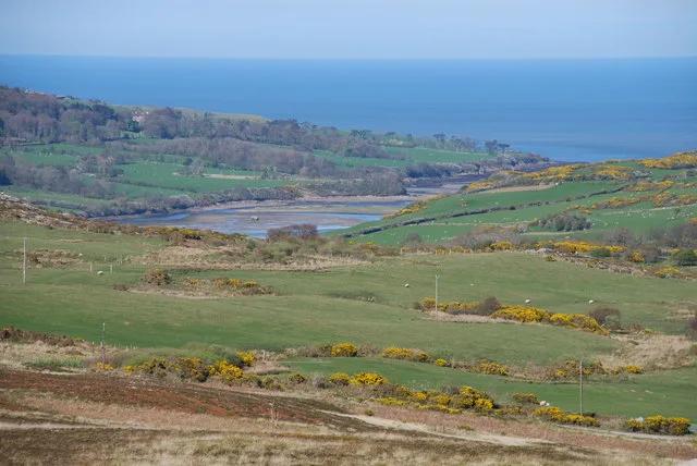
Ynys Dulas (Welsh for 'Dulas Island') is a small island located off the north-east coast of Anglesey (Welsh: Ynys Môn), Wales. It marks the most eastern part of the parish of Llaneilian. The island is situated about a mile and a half offshore, within Dulas Bay. The size of the island depends on the tide, with a maximum length of 623 metres and width of 207 metres against a minimum of 184 metres by 35 metres. It has a maximum area of 18.3 acres (74,000 m2). The island is mainly rocky, but at low tide sand is exposed, most noticeably on the southern part of the island where it separates the main rock formation from two smaller ones named Garnog ('Hooves'). Seals are often spotted living on and around the island, but it is too small for human inhabitation. There is also very little flora on the island owing to its rocky composition. However, on lower lying parts of the island, exposed at low tide, seaweeds and other sea plants live. A smaller rock called Garreg Allan ('The Outer, Expelled or Furthest Stone') is found about 100 m behind the island, but is not visible with the naked eye from the shore. A raised shelf of seabed about 1.5 km long reaches out a little beyond Garreg Allan, meaning that the sea around it is no more than 5 metres deep. This is followed by a drop to water much deeper (over 20 metres deep), which indicates that Ynys Dulas may have been part of a recently (geologically speaking) submerged headland. The island also marks the termination of an old limestone headland which geologically separated Dulas Bay from Lligwy Bay and Red Wharf Bay. The island has a rescue tower that once stored food and provided shelter for shipwrecked seamen. The cylindrical, stone-cone-shaped structure was completed in 1824 by Colonel James Hughes of Llys Dulas Manor. A map drawn up in September 1748 by Lewis Morris shows the island named as Ynys Gadarn (Strong or Mighty Island) not Ynys Dulas.
Excerpt from Wikipedia under CC BY-SA 4.0. See the source article linked in Sources below.
- Coordinates
- 53.3833, -4.2500
- District
- Isle of Anglesey
- Parish
- Llaneilian
- Postcode
- LL70 9LJ
- Parliamentary constituency
- Ynys Môn
Sources
- wikidata: Q3401437 (CC0)
- wikipedia: Ynys Dulas (CC BY-SA 4.0)
Other places nearby
Loading nearby places…
Nearby
 📷 5
📷 5Natural landmarks · North Wales
Dulas Bay
Dulas Bay — a natural feature in wales north.
 📷 3
📷 3Mountains & hills · North Wales
Dulas Bay
Dulas Bay — bay in Wales, United Kingdom.
 📷 3
📷 3Beaches · North Wales
Traeth yr Ora
Traeth yr Ora is a beach in the United Kingdom.
 📷 3
📷 3Historic churches · North Wales
Old Church of St Gwenllwyfo, Llanwenllwyfo
Old Church of St Gwenllwyfo, Llanwenllwyfo — church in Anglesey, UK.
 📷 3
📷 3Historic houses · North Wales
Old Llanwenllwyfo Church
Old Llanwenllwyfo Church — a historic house in wales-north, United Kingdom.
 📷 3
📷 3Mountains & hills · North Wales
Lligwy Bay
Lligwy Bay — bay in the United Kingdom.
More places in this region
 📷 5
📷 5Islands · North Wales
Anglesey
Anglesey — island in north-west Wales, UK.
 📷 5
📷 5Islands · North Wales
Bardsey Island
Bardsey Island — island off the coast of North Wales.
 Flagship📷 5
Islands · North Wales
Church Island
Church Island — island in Anglesey, Wales.
 Flagship📷 3
Islands · North Wales
Holy Island
Holy Island — island next to the island of Anglesey, Wales.
Frequently asked questions
- Where is Ynys Dulas?
- Ynys Dulas is in North Wales, United Kingdom (postcode LL70 9LJ), in the parish of Llaneilian.
- What is Ynys Dulas?
- Ynys Dulas — island in United Kingdom.
- How do I get to Ynys Dulas?
- Drivers can use postcode LL70 9LJ.
- Is Ynys Dulas free to visit?
- Yes, Ynys Dulas is free to enter.
- How do I get to Ynys Dulas?
- Drivers can navigate to postcode LL70 9LJ. It sits within the Ynys Môn parliamentary constituency.