Historic bridges · Yorkshire & the Humber
Way of the Roses
In or near Marton-le-Moor.
The Way of the Roses is a coast-to-coast long-distance cycle route of Great Britain and is based on minor roads, disused railway lines and specially constructed cycle paths. It lies entirely within th

Gordon Hatton — CC BY-SA 2.0 via Wikimedia Commons licence
Plan your visit
- Typical visit
- 15 min–30 min
- Nearest railway station
- Knaresborough · 9.7 km
- Free entry
- Dog-friendly
- Limited wheelchair access
Getting there & planning your visit
To visit the Way of the Roses, the nearest railway station is Knaresborough, located 9.7 km away. Entry is free, but please note that wheelchair accessibility is limited. The postcode for sat-nav is HG3 3RQ.
About
The Way of the Roses is a coast-to-coast long-distance cycle route of Great Britain and is based on minor roads, disused railway lines and specially constructed cycle paths. It lies entirely within the counties of Lancashire and Yorkshire, crossing the Yorkshire Dales and the Yorkshire Wolds in the North of England, passing through the historic cities of Lancaster, Ripon and York and scenic towns and villages including Settle and Pateley Bridge At 170 miles (270 km) long, the route is designed for the whole range of cyclists, from families to cycling club riders. Although a challenge with some hard climbs, the highest point being over 1,312 feet (400 m), the route is steadily increasing in popularity and is fully open and signed. The route is named after the Wars of the Roses, a 15th-century war between the English dynastic families Lancaster and York.
Photo gallery
From the Wikipedia article
The Way of the Roses is a coast-to-coast long-distance cycle route of Great Britain and is based on minor roads, disused railway lines and specially constructed cycle paths. It lies entirely within the counties of Lancashire and Yorkshire, crossing the Yorkshire Dales and the Yorkshire Wolds in the North of England, passing through the historic cities of Lancaster, Ripon and York and scenic towns and villages including Settle and Pateley Bridge At 170 miles (270 km) long, the route is designed for the whole range of cyclists, from families to cycling club riders. Although a challenge with some hard climbs, the highest point being over 1,312 feet (400 m), the route is steadily increasing in popularity and is fully open and signed. The route is named after the Wars of the Roses, a 15th-century war between the English dynastic families Lancaster and York.
Excerpt from Wikipedia under CC BY-SA 4.0. See the source article linked in Sources below.
Background
History
The route was developed by Sustrans and part of the National Cycle Network (NCN Route 69) in partnership with various Local Authorities, Lancaster City Council, Cyclists Touring Club, Bridlington Renaissance Partnership and Welcome to Yorkshire amongst others. The route was opened in 2010 running from Morecambe on the west coast of Lancashire to the east coast at Bridlington. A second diversion between Pateley Bridge and York that goes via Harrogate and Knaresborough was opened in 2011. Additionally, there is a section that links Kingston upon Hull to the cycle route that joins/leaves near Pocklington rather than going to/from Bridlington.
Sourced from Wikipedia under CC BY-SA 4.0.
- Coordinates
- 54.0964, -1.4804
- District
- North Yorkshire
- Parish
- Bishop Monkton
- Postcode
- HG3 3RQ
- Parliamentary constituency
- Wetherby and Easingwold
- Established
- 2010
- Nearest railway station
- Knaresborough — 9.7 km
Sources
- wikipedia: Way of the Roses (CC BY-SA 4.0)
Other places nearby
Sep2003.jpg?width=1200)
Newby Hall
Gardens · 0.9 km
.jpg?width=1200)
Charles II Trampling Cromwell
Historic houses · 1.0 km

Church Farm Caravan Park
Campsites · 1.6 km
Church of Christ the Consoler
Historic churches · 2.2 km

Givendale Manor House
Archaeological sites · 2.5 km
Givendale Manor House
Castles · 2.5 km

Hollin Hall
Historic houses · 2.8 km

Roecliffe Park
Caravan parks · 3.4 km

Hewick Bridge Over River Ure
Historic bridges · 3.5 km

St Helen's Cottage
Historic houses · 3.5 km
St Mary's Church, Roecliffe
Historic churches · 3.5 km

Copgrove
Villages · 3.6 km
Nearby
📷 5Gardens · Yorkshire & the Humber
Newby Hall
Newby Hall — Grade I listed country house in North Yorkshire, England, UK.
📷 4Historic houses · Yorkshire & the Humber
Charles II Trampling Cromwell
Charles II Trampling Cromwell — Public artwork (statue).
📷 5Campsites · Yorkshire & the Humber
Church Farm Caravan Park
Church Farm Caravan Park — a campsite in england yorkshire.
📷 5Historic churches · Yorkshire & the Humber
Church of Christ the Consoler
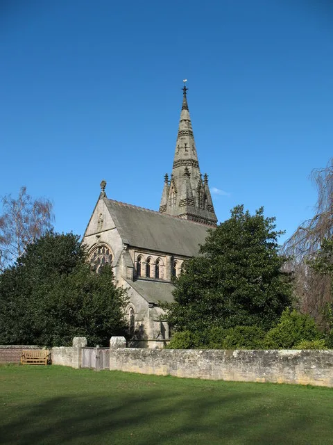
Church of Christ the Consoler — church in Skelton-on-Ure, Yorkshire, England.
📷 5Archaeological sites · Yorkshire & the Humber
Givendale Manor House
Givendale Manor House — archaeological in england yorkshire.
📷 5Castles · Yorkshire & the Humber
Givendale Manor House
Givendale Manor House — a castle in england yorkshire.
Where to eat & stay near Way of the Roses
Places to stay
📷 5Campsites · Yorkshire & the Humber
Church Farm Caravan Park
Church Farm Caravan Park — a campsite in england yorkshire.
📷 5Caravan parks · Yorkshire & the Humber
Roecliffe Park
Roecliffe Park — a caravan park in england yorkshire.
 📷 5
📷 5Caravan parks · Yorkshire & the Humber
Ripon - Lockside Caravan Site
Ripon - Lockside Caravan Site — a caravan park in england yorkshire.
 📷 5
📷 5Caravan parks · Yorkshire & the Humber
Boroughbridge Camping And Caravanning Club Site
Boroughbridge Camping And Caravanning Club Site — a caravan park in england yorkshire.
 📷 5
📷 5Caravan parks · Yorkshire & the Humber
Headlands Caravan Park
Headlands Caravan Park — a caravan park in england yorkshire.
 📷 5
📷 5Caravan parks · Yorkshire & the Humber
Bluebell Caravan Park
Bluebell Caravan Park — a caravan park in england yorkshire.
Places to eat & drink
 📷 5
📷 5Cafés · Yorkshire & the Humber
Lula's Café
Lula's Café — a café in england yorkshire.
 📷 7
📷 7Historic pubs · Yorkshire & the Humber
The Fleece Public House
The Fleece Public House in England Yorkshire, United Kingdom.
 📷 5
📷 5Historic pubs · Yorkshire & the Humber
The Unicorn Hotel
The Unicorn Hotel in England Yorkshire, United Kingdom.
 📷 7
📷 7Historic pubs · Yorkshire & the Humber
Lamb And Flag Public House
Lamb And Flag Public House in England Yorkshire, United Kingdom.
 📷 7
📷 7 📷 7
📷 7Historic pubs · Yorkshire & the Humber
Ye Hornblower Tavern
Ye Hornblower Tavern in England Yorkshire, United Kingdom.
More bridges in this region
 📷 5
📷 5Historic bridges · Yorkshire & the Humber
Broadbottom Viaduct
Broadbottom Viaduct is a historic bridge in the United Kingdom.
 📷 3
📷 3Historic bridges · Yorkshire & the Humber
Goyt Cliff Viaduct
Goyt Cliff Viaduct is a historic bridge in the United Kingdom.
 📷 3
📷 3Historic bridges · Yorkshire & the Humber
Iron Bridge
Iron Bridge is a historic bridge in the United Kingdom.
.jpg?width=1200) 📷 5
📷 5Historic bridges · Yorkshire & the Humber
Marple Aqueduct
Marple Aqueduct is a historic bridge in the United Kingdom.
Frequently asked questions
- Where is Way of the Roses?
- Way of the Roses is in Yorkshire, United Kingdom (postcode HG3 3RQ), in the parish of Bishop Monkton.
- What is Way of the Roses?
- The Way of the Roses is a coast-to-coast long-distance cycle route of Great Britain and is based on minor roads, disused railway lines and specially constructed cycle paths. It lies entirely within th
- How do I get to Way of the Roses?
- The nearest railway station is Knaresborough, about 9.7 km away. Drivers can use postcode HG3 3RQ.
- When was Way of the Roses built?
- Built or established in 2010.
- Is Way of the Roses free to visit?
- Yes, Way of the Roses is free to enter.
- How do I get to Way of the Roses?
- Drivers can navigate to postcode HG3 3RQ. It sits within the Wetherby and Easingwold parliamentary constituency.