
Hill forts · East of England
Waulud's Bank
In or near Leagrave.
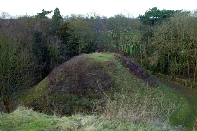
Waulud's Bank — archaeological site in Luton, Bedfordshire, England, UK.

Wikimedia Commons contributors — see linked file page for photographer and licence licence
.jpg)
Plan your visit
- Typical visit
- 1 h–2 h
- Nearest railway station
- Leagrave · 0.5 km
- Free entry
- Dog-friendly
Getting there & planning your visit
Waulud's Bank is located in Luton, with the nearest railway station being Leagrave, just 0.5 km away. Entry to the site is free.
About
Waulud's Bank is a hill fort in the United Kingdom. Heritage designation: scheduled monument. Wikidata describes it as: "archaeological site in Luton, Bedfordshire, England, UK". Coordinates: 51.9099°, -0.4582°.
Photo gallery
Official information
Al Furqan is a community organization in Luton that serves the local Sri Lankan Muslim community. It offers various services aimed at promoting religious harmony, education, and cultural heritage.
Protected designations
- Area of Outstanding Natural Beauty: Chilterns
Designations sourced from Natural England open data under OGL v3.
From the Wikipedia article
Waulud's Bank is a possible Neolithic henge in Leagrave, Luton, England dating from 3000 BC. The Waulud's Bank earthworks are in the north of Luton on the edge of Leagrave Common, with central Leagrave to the south east and Marsh Farm to the west. The River Lea runs alongside on the western side, its source located within the vicinity of the surrounding marsh. Archaeological excavations in 1953, 1971 and 1982 date the site to around 3000 BC, in the Neolithic period, although there was evidence of earlier mesolithic hunter/fisher activity in the immediate area. The 'D' shape of the earthwork is almost identical to that of Marden Henge in Wiltshire, both sites have a river forming one side, and each produced neolithic grooved-ware pottery. Waulud's Bank lies on a glacial ridge near which runs the prehistoric Icknield Way. Initially it was probably a domestic enclosure used for cattle herding. It has been suggested that it later became a henge monument, although the position of its surrounding ditch outside its timber-faced bank would be unusual. Evidence suggests that the site was briefly re-used in the Iron Age, during the Roman occupation and in medieval times. The enclosure consists of a bank and external ditch of around 7 hectares with a turf-revetted chalk and gravel bank faced by a wooden stockade. No entrances have been identified. Most external features have been destroyed by a 19th-century gravel quarry on the south, and the dumping of tons of chalk and top-soil along the eastern side during building construction of Marsh Farm in the 1970s. Geophysical surveys in July 1985 and January 2009 failed to reveal any very positive indications of internal features. The bank stands 2.6 metres (8.5 ft) high in places; on the north side the excavated ditch was 9.2 metres (30 ft) wide and 2.1 metres (6.9 ft) deep. Finds included neolithic pottery, animal bones and flint arrow heads, some on display at Stockwood Heritage Centre, Luton Museum. The building at the edge of…
Excerpt from Wikipedia under CC BY-SA 4.0. See the source article linked in Sources below.
- Coordinates
- 51.9099, -0.4582
- District
- Luton
- Parish
- Luton, unparished area
- Postcode
- LU3 2SR
- Parliamentary constituency
- Luton North
- Nearest railway station
- Leagrave — 0.5 km
- Opening
- Monday – Friday 9am – 5pm; Saturdays 11am – 5pm; Sundays 9am – 3pm
- Official site
- alfurqanllm.org
Sources
- wikidata: Q2552830 (CC0)
- wikipedia: Waulud's Bank (CC BY-SA 4.0)
- commons: GOC Leagrave to Harpenden 010 Waulud's Bank (8548556990).jpg (CC BY-SA 4.0)
Other places nearby

Lea Valley Walk
Military museums · 0.2 km
Al Furqan Mosque
Historic churches · 0.5 km

Masjid Bilal
Historic churches · 0.8 km
Masjid Bilal ... (Sunni)
Historic churches · 0.8 km

Al Falah Community Centre
Historic churches · 0.8 km

Hockwell Ring Masjid
Historic churches · 0.8 km

Leagrave
Towns & cities · 0.9 km
Faizan-e-Mushkil Kusha
Historic churches · 1.1 km

Sundon Park
Villages · 1.2 km

Old Moat House
Restaurants · 1.7 km

Jamia Al-Alkbaria
Historic churches · 1.8 km

Luton Hebrew Congregation Synagogue
Historic churches · 1.9 km
Nearby
📷 5Military museums · East of England
Lea Valley Walk
Lea Valley Walk — a military museum in england london.
Historic churches · East of England
Al Furqan Mosque
Al Furqan Mosque — a church in england east.
📷 5Historic churches · East of England
Masjid Bilal
Masjid Bilal — a church in East of England, United Kingdom.
📷 5Historic churches · East of England
Masjid Bilal ... (Sunni)
Masjid Bilal ... (Sunni) — a church in East of England, United Kingdom.
📷 5Historic churches · East of England
Al Falah Community Centre
Al Falah Community Centre — a church in East of England, United Kingdom.
📷 5Historic churches · East of England
Hockwell Ring Masjid
Hockwell Ring Masjid — a church in East of England, United Kingdom.
Where to eat & stay near Waulud's Bank
Places to stay
 📷 7
📷 7Hotels · East of England
Spark by Hilton Luton
Spark by Hilton Luton — a hotel in england london. 4-star. Brand: Spark by Hilton.
 📷 7
📷 7Hotels · East of England
The Red Lion hotel
The Red Lion hotel — a hotel in england london.
 📷 5
📷 5Hostels · East of England
Stockwood Hotel
Stockwood Hotel — a hostel in england london.
 📷 3
📷 3Hotels · East of England
Hilton Garden Inn Luton North
Hilton Garden Inn Luton North — a hotel in england london. 4-star. Brand: Hilton Garden Inn.
 📷 5
📷 5Hotels · East of England
Hampton by Hilton London Luton Airport
Hampton by Hilton London Luton Airport — a hotel in england london. 3-star. Brand: Hampton.
 📷 5
📷 5Places to eat & drink
📷 5Restaurants · East of England
Old Moat House
Old Moat House — a restaurant in england london. Cuisine: pizza. Brand: Stonehouse Pizza & Carvery.
 📷 5
📷 5 📷 5
📷 5Historic pubs · East of England
The Fountain Public House
The Fountain Public House in England East, United Kingdom.
 📷 5
📷 5Historic pubs · East of England
Lilley Arms Public House
Lilley Arms Public House in England East, United Kingdom.
 📷 5
📷 5Historic pubs · East of England
The Old Sun Public House
The Old Sun Public House in England East, United Kingdom.
 📷 5
📷 5Historic pubs · East of England
Bedford Arms Public House
Bedford Arms Public House in England East, United Kingdom.
More places in this region
 📷 5
📷 5Hill forts · East of England
Bartlow Hills
Bartlow Hills — Roman tumuli cemetery in Bartlow (Cambridgeshire, UK).
 📷 5
📷 5Hill forts · East of England
Bedford Castle
Bedford Castle — castle in Bedfordshire, England, UK.
.jpg?width=1200) 📷 5
📷 5Hill forts · East of England
Beech Bottom Dyke
Beech Bottom Dyke — Iron Age ditch in St Albans, Hertfordshire, England, UK.
 📷 5
📷 5Hill forts · East of England
Braughing Roman Town
Braughing Roman Town — archaeological site in Braughing, East Hertfordshire, England, UK.
Frequently asked questions
- Where is Waulud's Bank?
- Waulud's Bank is in East of England, United Kingdom (postcode LU3 2SR), in the parish of Luton, unparished area.
- What is Waulud's Bank?
- Waulud's Bank — archaeological site in Luton, Bedfordshire, England, UK.
- How do I get to Waulud's Bank?
- The nearest railway station is Leagrave, about 0.5 km away. The nearest town is Leagrave. Drivers can use postcode LU3 2SR.
- Is Waulud's Bank a listed building?
- Waulud's Bank is officially recognised as scheduled monument listed.
- Is Waulud's Bank a protected site?
- Yes — Waulud's Bank is part of the Chilterns National Landscape (AONB).
- Is Waulud's Bank free to visit?
- Yes, Waulud's Bank is free to enter.
- How do I get to Waulud's Bank?
- The nearest railway station is Leagrave, about 0.5 km away. Drivers can navigate to postcode LU3 2SR.