Mountains & hills · North West England
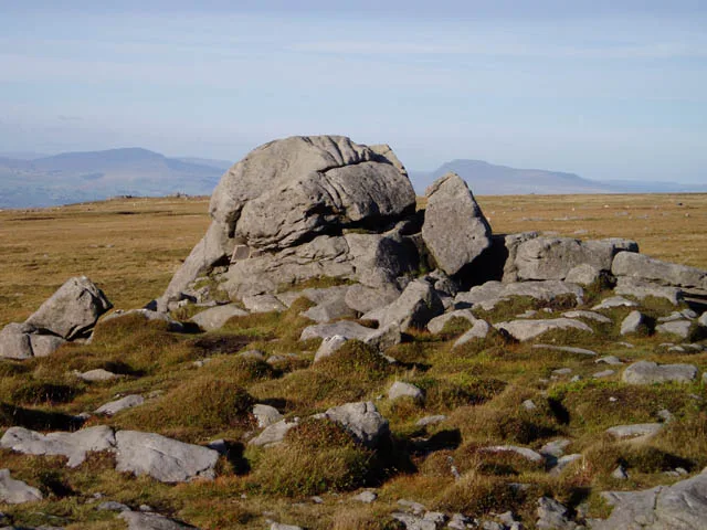
Ward's Stone
In or near Abbeystead.
Ward's Stone — Named summit at 563 m.

Wikimedia Commons contributors — see linked file page for photographer and licence licence
Plan your visit
- Typical visit
- 3 h–8 h
- Best time of year
- Late spring – early autumn (May–Oct)
- Free entry
- Dog-friendly
About
Ward's Stone is a named summit in the United Kingdom. Wikidata describes it as: "Named summit at 563 m.". Coordinates: 54.0230°, -2.6243°.
Photo gallery
Protected designations
- Site of Special Scientific Interest: Bowland Fells SSSI
- Area of Outstanding Natural Beauty: Forest Of Bowland
Designations sourced from Natural England open data under OGL v3.
From the Wikipedia article
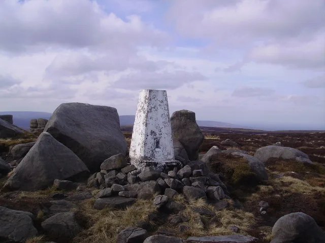
Ward's Stone is the highest hill in the Forest of Bowland, England. Its flat top hides two trig points nearly a kilometre apart. The western trig point sits atop of large rocks, including one, the Ward's Stone, that is so large it attracts boulderers and climbers. The path from Grit Fell is difficult: crossing Cabin Flat, it weaves its way across hidden pools of stagnant water, the presence of which is betrayed by a form of red grass. White markers supposedly point out the way, but more often result in leading the walker astray. The second trig points faces the empty vastness of the eastern Forest of Bowland, with the summits of Wolfhole Crag, White Hill and the distant Ingleborough breaking the horizon. A second path approaches Ward's Stone from Tarnbrook, where limited parking is available. On the southern slope of this hill are Thorn Crag, Hell Crag and Long Crag, rocky outcroppings that are popular with climbers. Within Thorn Crag, a shallow cave system exists that leads to Hell Crag; this route was first traversed by Lancaster University Mountaineering Club.
Excerpt from Wikipedia under CC BY-SA 4.0. See the source article linked in Sources below.
- Coordinates
- 54.0230, -2.6243
- Address
- Lancashire, England
Sources
- osm: n11280711003 (ODbL)
- wikipedia: Ward's Stone (CC BY-SA 4.0)
- commons: Ward's Stone - geograph.org.uk - 49511.jpg (CC BY-SA 4.0)
Other places nearby

Ward's Stone
Natural landmarks · 0.0 km

BS 1890
Memorials & monuments · 0.4 km
Ward's Stone (West)
Mountains & hills · 0.6 km

Whitespout
Waterfalls · 2.2 km

Anthony Mason Hornby
Memorials & monuments · 2.5 km

Tarnbrook
Villages · 3.1 km

Grit Fell
Mountains & hills · 3.5 km

Brennand Great Hill
Mountains & hills · 3.9 km
Wolfhole Crag
Natural landmarks · 3.9 km

Littledale Hall
Historic houses · 4.1 km

Lee Bridge
Historic bridges · 4.2 km

Grizedale Bridge
Historic bridges · 4.3 km
Nearby
📷 3Natural landmarks · North West England
Ward's Stone
Ward's Stone — mountain in the United Kingdom.
📷 3Memorials & monuments · North West England
BS 1890
BS 1890 — a memorial in england-north-west, United Kingdom.
📷 3Mountains & hills · North West England
Ward's Stone (West)
Ward's Stone (West) — Named summit at 560 m.
📷 5📷 3Memorials & monuments · North West England
Anthony Mason Hornby
Anthony Mason Hornby — a memorial in england-north-west, United Kingdom.
📷 5Where to eat & stay near Ward's Stone
Places to stay
 📷 5
📷 5Campsites · North West England
Crossghyll Farm Camping Pods
Crossghyll Farm Camping Pods — a campsite in england north west.
 📷 5
📷 5Campsites · North West England
Littledale Scout Camp
Littledale Scout Camp — a campsite in england north west.
 📷 5
📷 5Campsites · North West England
Bridge House Farm Campsite
Bridge House Farm Campsite — a campsite in england north west.
 📷 5
📷 5Caravan parks · North West England
Crook O'Lune Caravan Park
Crook O'Lune Caravan Park — a caravan park in england north west.
📷 5Hotels · North West England
Scarthwaite Country House Hotel
Scarthwaite Country House Hotel — a hotel in england north west.
 📷 5
📷 5Caravan parks · North West England
New Parkside Farm Caravan Park
New Parkside Farm Caravan Park — a caravan park in england north west.
Places to eat & drink
 📷 3
📷 3Historic pubs · North West England
The Borough
The Borough — Historic pub — listed building or notable heritage status.
 📷 5
📷 5 📷 5
📷 5Historic pubs · North West England
Toll House Inn Hotel
Toll House Inn Hotel — Historic pub — listed building or notable heritage status.
 📷 7
📷 7 📷 5
📷 5Historic pubs · North West England
Brown Cow Public House
Brown Cow Public House in England North West, United Kingdom.
.jpg?width=1200) 📷 4
📷 4Historic pubs · North West England
The Bobbin
The Bobbin — Historic pub — listed building or notable heritage status.
More mountains in this region
 📷 5
📷 5Mountains & hills · North West England
Appleton Park
Appleton Park — a hill or mountain in england west midlands.
 📷 5
📷 5Mountains & hills · North West England
High Warren
High Warren — mountain in england west midlands. Elevation: 105 m.
 📷 5
📷 5Mountains & hills · North West England
Alderley Edge
Alderley Edge — mountain in england west midlands. Elevation: 194 m.
 📷 3
📷 3Frequently asked questions
- Where is Ward's Stone?
- Ward's Stone is in North-West England, United Kingdom.
- What is Ward's Stone?
- Ward's Stone — Named summit at 563 m.
- How do I get to Ward's Stone?
- Its coordinates are 54.0230°, -2.6243°.
- Is Ward's Stone a protected site?
- Yes — Ward's Stone is part of the Bowland Fells SSSI Site of Special Scientific Interest and the Forest Of Bowland National Landscape (AONB).
- Is Ward's Stone free to visit?
- Yes, Ward's Stone is free to enter.