
Cemeteries · South West England
Urchfont Cemetery
In or near Market Lavington.
Urchfont Cemetery is a cemetery in the United Kingdom.

Chris Heaton — CC BY-SA 2.0 via Wikimedia Commons licence

Plan your visit
- Typical visit
- 30 min–1 h
- Free entry
- Dog-friendly
About
Urchfont Cemetery is a cemetery in South-East England of architectural and local-history note. The site is within the North Wessex Downs National Landscape (AONB), and is a designated Site of Special Scientific Interest. It sits within the Melksham and Devizes parliamentary constituency. Postcode area SN10.
Photo gallery
Protected designations
- Site of Special Scientific Interest: River Avon System SSSI
- Area of Outstanding Natural Beauty: North Wessex Downs
Designations sourced from Natural England open data under OGL v3.
From the Wikipedia article
Urchfont is a rural village and civil parish in the southwest of the Vale of Pewsey and north of Salisbury Plain in Wiltshire, England, about 3+1⁄2 miles (6 km) southeast of the market town of Devizes. The hamlet of Cuckoo's Corner is in the northwest of the village; the parish includes the hamlets of Wedhampton (grid reference SU060577) and Lydeway (SU052578). The population of the parish at the 2011 census was 1,075. Urchfont village lies mostly to the north of the B3098 road which connects Market Lavington to the A342 Devizes-Upavon road. The parish narrows as it extends southeast onto Salisbury Plain and into the military training area.
Excerpt from Wikipedia under CC BY-SA 4.0. See the source article linked in Sources below.
Background
History
There are remains of several bowl barrows on the downland in the south of the parish, Medieval strip lynchets can be seen on the north-facing slope of Urchfont Hill. Domesday Book in 1086 recorded a large settlement of 82 households at Lerchesfonte, with three mills, and land held by St Mary's Abbey, Winchester. The land (later as separate estates of Urchfont, Northcombe and Wedhampton) continued in the ownership of the abbey until the Dissolution in the 1530s. housed an adult education college from 1947 until 2012, when it returned to residential use. Downland in the south of the parish was bought by the War Department in stages from 1897, and today forms part of the military Salisbury…
Sourced from Wikipedia under CC BY-SA 4.0.
- Coordinates
- 51.3114, -1.9390
- District
- Wiltshire
- Parish
- Urchfont
- Postcode
- SN10 4RT
- Parliamentary constituency
- Melksham and Devizes
- Official site
- www.urchfont-pc.gov.uk
Sources
Other places nearby

Urchfont
Villages · 0.3 km
.jpg?width=1200)
Eastville House
Historic houses · 0.3 km

Urchfont War Memorial
Memorials & monuments · 0.4 km
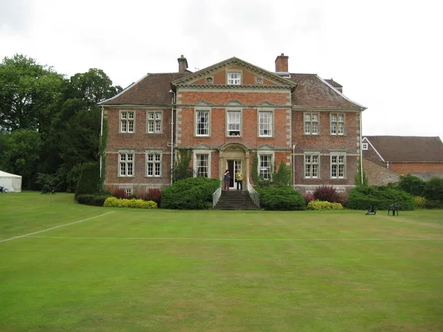
Urchfont Manor
Stately homes · 0.8 km

Planks Farm Shop
Farmers’ markets · 1.2 km

Urchfont Hill
Mountains & hills · 1.4 km
Urchfont Hill
Mountains & hills · 1.4 km

Wedhampton Manor
Manor houses · 1.8 km

Conock Old Manor
Manor houses · 2.4 km

Eastcott Manor
Manor houses · 2.4 km
Conock Manor
Manor houses · 2.5 km

Wiltshire
Museums · 3.0 km
Nearby
📷 5📷 5Historic houses · South West England
Eastville House
Eastville House — house in Urchfont, Wiltshire, England, UK.
📷 5Memorials & monuments · South West England
Urchfont War Memorial
Urchfont War Memorial — Grade II listed building-listed memorial in england-south-east, United Kingdom.
📷 5Stately homes · South West England
Urchfont Manor
Urchfont Manor — manor house in Wiltshire, England, UK.
📷 5Farmers’ markets · South West England
Planks Farm Shop
Planks Farm Shop — a UK farmers' market in england south east.
📷 5Mountains & hills · South West England
Urchfont Hill
Urchfont Hill — mountain in england south east. Elevation: 210 m.
Where to eat & stay near Urchfont Cemetery
Places to stay
 📷 5
📷 5Campsites · South West England
Wiltshire County Scout Centre
Wiltshire County Scout Centre — a campsite in england south east.
 📷 5
📷 5B&Bs · South West England
Puckshipton House
Puckshipton House — a bed-and-breakfast in england south east.
 📷 7
📷 7Hotels · South West England
The Castle Hotel
The Castle Hotel — a hotel in england south east.
 📷 7
📷 7Hotels · South West England
The Peppermill Hotel
The Peppermill Hotel — a hotel in england south east.
 📷 5
📷 5Hotels · South West England
The Bear Hotel
The Bear Hotel — a hotel in england south east.
 📷 5
📷 5Caravan parks · South East England
Charlton Manor
Charlton Manor — a caravan park in england south east.
Places to eat & drink
 📷 5
📷 5 📷 7
📷 7Historic pubs · South West England
Black Swan Hotel
Black Swan Hotel in England South West, United Kingdom.
 📷 7
📷 7Historic pubs · South West England
The Talbot Public House
The Talbot Public House in England South West, United Kingdom.
 📷 5
📷 5Historic pubs · South West England
Bricklayers Arms Public House
Bricklayers Arms Public House in England South West, United Kingdom.
 📷 6
📷 6Restaurants · South West England
New China Cottage
New China Cottage — a restaurant in england south east.
 📷 5
📷 5Historic pubs · South West England
The Castle Public House
The Castle Public House in England South West, United Kingdom.
More cemeteries in this region
.jpg?width=1200) 📷 5
📷 5Cemeteries · South West England
Bath Abbey Cemetery
Bath Abbey Cemetery is a cemetery in the United Kingdom.
 📷 5
📷 5Cemeteries · South West England
Bath Jewish Burial Ground
Bath Jewish Burial Ground is a cemetery in the United Kingdom.
 📷 5
📷 5Cemeteries · South West England
Bath Natural Burial Meadow
Bath Natural Burial Meadow is a cemetery in the United Kingdom.
 📷 5
📷 5Cemeteries · South West England
Bath Union Workhouse Burial Ground
Bath Union Workhouse Burial Ground is a cemetery in the United Kingdom.
Frequently asked questions
- Where is Urchfont Cemetery?
- Urchfont Cemetery is in South-West England, United Kingdom (postcode SN10 4RT), in the parish of Urchfont.
- What is Urchfont Cemetery?
- Urchfont Cemetery is a cemetery in the United Kingdom.
- How do I get to Urchfont Cemetery?
- The nearest town is Market Lavington. Drivers can use postcode SN10 4RT.
- Is Urchfont Cemetery a protected site?
- Yes — Urchfont Cemetery is part of the River Avon System SSSI Site of Special Scientific Interest and the North Wessex Downs National Landscape (AONB).
- Is Urchfont Cemetery free to visit?
- Yes, Urchfont Cemetery is free to enter.
- How do I get to Urchfont Cemetery?
- Drivers can navigate to postcode SN10 4RT. It sits within the Melksham and Devizes parliamentary constituency.