Castles · North East England
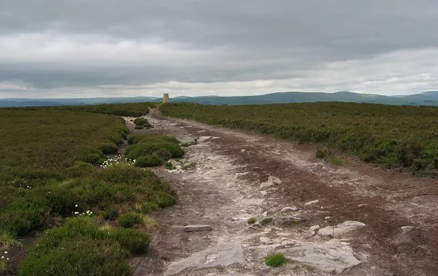
Thrunton Wood
In or near Glanton.
Thrunton Wood in England North East, United Kingdom.

Russel Wills — CC BY-SA 2.0 via Wikimedia Commons licence
Plan your visit
- Typical visit
- 1.5 h–3 h
- Family-friendly
- Limited wheelchair access
About
Thrunton Wood is a place of interest in England North East, United Kingdom — drawn from open-data sources for visitor reference. See the linked Wikipedia article for the full description.
Photo gallery
Protected designations
- Site of Special Scientific Interest: River Coquet and Coquet Valley Woodlands SSSI
- Site of Special Scientific Interest: Northumberland Shore SSSI
- Area of Outstanding Natural Beauty: Northumberland Coast
Designations sourced from Natural England open data under OGL v3.
From the Wikipedia article
Thrunton Wood is an area of woodland and open moor, and is located 5 miles (8.0 kilometres) north of Rothbury, which in itself a small market town in Northumberland. It is a popular destination with walkers/hikers, mountain bikers and horse riders, and is home to two waymarked walking trails: Castle Hill walk (5 miles), and Crag Top walk (1 mile). There is an Iron Age fort on Castle Hill, and Thrunton Wood is home to several caves, including Macartney's Cave, once home to a local monk, and Thomas Wedderburn's Hole, where a local highwayman reputedly once hid from the law. It was heavily affected by Storm Arwen (back in November 2021) which made it mostly inaccessible to public due to a large number of fallen/uprooted trees. More recently, a lot of the trees have been cut down. There is also a popular trout fishery nearby, located just a quarter mile to the east.
Excerpt from Wikipedia under CC BY-SA 4.0. See the source article linked in Sources below.
- Coordinates
- 55.3671, -1.8759
- District
- Northumberland
- Parish
- Whittingham
- Postcode
- NE66 4SQ
- Parliamentary constituency
- North Northumberland
- Official site
- www.forestryengland.uk
Sources
- wikidata: Q65050926 (CC0)
- wikipedia: Thrunton Wood (CC BY-SA 4.0)
Other places nearby

Coeburn
Caravan parks · 1.0 km

Coe Crag
Mountains & hills · 1.1 km

Callaly Crag
Mountains & hills · 1.8 km

Rimside Moor
Mountains & hills · 1.9 km
Long Crag
Mountains & hills · 2.1 km

Old Callaly Castle Hill
Castles · 2.4 km

Castle Hill Callaly
Memorials & monuments · 2.5 km

Swallow Knowe
Mountains & hills · 2.6 km

Callaly
Archaeological sites · 2.8 km

Wellhope Knowe
Mountains & hills · 3.2 km
Callaly Castle
Castles · 3.2 km

Edlingham
Other places · 3.4 km
Nearby
📷 5📷 5Mountains & hills · North East England
Coe Crag
Coe Crag — mountain in scotland lowlands. Elevation: 308 m.
📷 5Mountains & hills · North East England
Callaly Crag
Callaly Crag — a hill or mountain in scotland lowlands.
📷 5Mountains & hills · North East England
Rimside Moor
Rimside Moor — mountain in scotland lowlands. Elevation: 216 m.
📷 3📷 5Castles · North East England
Old Callaly Castle Hill
Old Callaly Castle Hill — a castle in scotland lowlands.
Where to eat & stay near Thrunton Wood
Places to stay
📷 5 📷 5
📷 5Caravan parks · North East England
Riverside Caravan Park Rothbury
Riverside Caravan Park Rothbury — a caravan park in scotland lowlands.
 📷 7
📷 7Hotels · North East England
Newcastle House Hotel
Newcastle House Hotel — a hotel in scotland lowlands.
 📷 5
📷 5Caravan parks · North East England
Coquetdale Holiday Park
Coquetdale Holiday Park — a caravan park in scotland lowlands.
 📷 5
📷 5Caravan parks · North East England
Whitton Glebe Caravan Park
Whitton Glebe Caravan Park — a caravan park in scotland lowlands.
 📷 7
📷 7B&Bs · North East England
The Granby Inn
The Granby Inn — a bed-and-breakfast in scotland lowlands.
Places to eat & drink
 📷 7
📷 7Historic pubs · North East England
Bridge Of Aln Hotel
Bridge Of Aln Hotel in Scotland Lowlands, United Kingdom.
 📷 7
📷 7Historic pubs · North East England
Plough Inn With Outbuilding To North
Plough Inn With Outbuilding To North in Scotland Lowlands, United Kingdom.
 📷 5
📷 5Historic pubs · North East England
The Anglers Arms
The Anglers Arms in Scotland Lowlands, United Kingdom.
 📷 7
📷 7Historic pubs · North East England
Crown Public House
Crown Public House in Scotland Lowlands, United Kingdom.
 📷 7
📷 7Historic pubs · North East England
Black Swan Public House
Black Swan Public House in Scotland Lowlands, United Kingdom.
 📷 5
📷 5More castles in this region
 📷 3
📷 3Castles · North East England
Scargill Castle
Scargill Castle — house in Scargill, County Durham, England, UK.
 📷 3
📷 3Castles · North East England
Roper Castle or Round Table (Roman Signal Station)
Roper Castle or Round Table (Roman Signal Station) — a castle in england-north-west, United Kingdom.
 📷 5
📷 5 📷 5
📷 5Castles · North East England
Appleby Castle
Appleby Castle — Grade I listed English country house in Appleby-in-Westmorland, United Kingdom.
Frequently asked questions
- Where is Thrunton Wood?
- Thrunton Wood is in North-East England, United Kingdom (postcode NE66 4SQ), in the parish of Whittingham.
- What is Thrunton Wood?
- Thrunton Wood in England North East, United Kingdom.
- How do I get to Thrunton Wood?
- Drivers can use postcode NE66 4SQ.
- Is Thrunton Wood a protected site?
- Yes — Thrunton Wood is part of the River Coquet and Coquet Valley Woodlands SSSI Site of Special Scientific Interest and the Northumberland Shore SSSI Site of Special Scientific Interest.
- Does Thrunton Wood charge admission?
- Thrunton Wood typically charges admission. Check the official site for current ticket prices and opening hours.
- How do I get to Thrunton Wood?
- Drivers can navigate to postcode NE66 4SQ. It sits within the North Northumberland parliamentary constituency.