
Historic churches · South East England
The Parish Church of St John the Divine
In or near Ferring.
The Parish Church of St John the Divine — a Grade I-listed church in england-south-east, United Kingdom.

nick macneill — CC BY-SA 2.0 via Wikimedia Commons licence

Plan your visit
- Typical visit
- 30 min–1 h
- Nearest railway station
- Goring-by-Sea · 3.8 km
- Free entry
Getting there & planning your visit
The Parish Church of St John the Divine is located in West Sussex, postcode BN13 3FA. The nearest railway station is Goring-by-Sea, which is 3.8 km away. Entry to the church is free.
About
The Parish Church of St John the Divine is a Grade I-listed building in england-south-east, United Kingdom. Grade I status is conferred by Historic England (or Cadw, Historic Environment Scotland or NIEA equivalents) on buildings of exceptional national interest. See the linked Wikipedia article for full historical and architectural details.
Photo gallery
Heritage listing
Details TQ 00 NE PATCHING THE STREET 10/44 (west side) 12.10.54 The Parish church of St John the Divine I Chancel with vestry to the north of it, tower in the position of a north transept with broached shingled spire, nave and south porch. C13 with some Perpendicular windows, restored in 1888, when the vestry, the south porch and the spire were added. Good small medieval flint church, rather much restored. Listing NGR: TQ0871806590 Legacy The contents of this record have been generated from a legacy data system. Legacy System number: 298012 Legacy System: LBS
From the Historic England List Entry under OGL v3.
Place summary
The Parish Church of St John the Divine is a Grade I listed church located in South-East England. Its architectural significance and historical value contribute to its esteemed status within the region.
AI-generated from the structured facts on this page (operator, designation, listing, era). Not a substitute for visiting.
- Coordinates
- 50.8486, -0.4570
- County
- West Sussex
- District
- Arun
- Parish
- Patching
- Postcode
- BN13 3FA
- Parliamentary constituency
- Worthing West
- Established
- 1250
- Nearest railway station
- Goring-by-Sea — 3.8 km
Sources
- wikidata: Q17528759 (CC0)
Other places nearby

Patching
Villages · 0.2 km

Clapham
Villages · 0.6 km

Clapham Wood Mystery
Parks · 0.8 km

Fox Wood Campsite
Campsites · 1.2 km

Castle Goring
Castles · 1.8 km

Castle Goring
Castles · 1.8 km

Michelgrove House (Ruins of)
Historic houses · 1.9 km

Highdown Hill
Mountains & hills · 2.3 km

Highdown Hill
Mountains & hills · 2.3 km
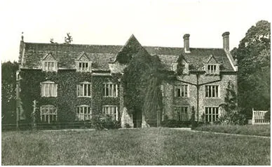
Ecclesden Manor
Stately homes · 2.4 km

The Miller's Tomb
Follies · 2.5 km

Northbrook Farm Caravan Club
Caravan parks · 2.6 km
Nearby
📷 5📷 5📷 5Parks · South East England
Clapham Wood Mystery
Clapham Wood Mystery — Woodland area in Clapham, West Sussex, England.
📷 5Campsites · South East England
Fox Wood Campsite
Fox Wood Campsite — a campsite in england south east.
📷 5Castles · South East England
Castle Goring
Castle Goring — a castle in england-south-east, United Kingdom.
📷 5Where to eat & stay near The Parish Church of St John the Divine
Places to stay
📷 5Campsites · South East England
Fox Wood Campsite
Fox Wood Campsite — a campsite in england south east.
📷 5Caravan parks · South East England
Northbrook Farm Caravan Club
Northbrook Farm Caravan Club — a caravan park in england south east.
 📷 5
📷 5Hotels · South East England
Angmering Manor Hotel
Angmering Manor Hotel — a hotel in england south east.
 📷 5
📷 5Caravan parks · South East England
Wild Heart Hill Camp
Wild Heart Hill Camp — a caravan park in england south east.
 📷 5
📷 5Caravan parks · South East England
Onslow Caravan Park
Onslow Caravan Park — a caravan park in england south east.
 📷 5
📷 5Places to eat & drink
 📷 5
📷 5Historic pubs · South East England
The Black Rabbit Public House
The Black Rabbit Public House in England South East, United Kingdom.
 📷 5
📷 5Historic pubs · South East England
The 6 Bells Public House
The 6 Bells Public House in England South East, United Kingdom.
 📷 5
📷 5Historic pubs · South East England
Locomotive Public House
Locomotive Public House in England South East, United Kingdom.
 📷 5
📷 5Historic pubs · South East England
The Newburgh Arms
The Newburgh Arms in England South East, United Kingdom.
 📷 5
📷 5Historic pubs · South East England
The Frankland Arms Public House
The Frankland Arms Public House in England South East, United Kingdom.
 📷 7
📷 7Historic pubs · South East England
St Marys Gate Public House
St Marys Gate Public House in England South East, United Kingdom.
More places in this region
 📷 5
📷 5Historic churches · South East England
All Saints Church, Frindsbury
All Saints Church, Frindsbury — church in Medway, UK.
 📷 5
📷 5Historic churches · South East England
All Saints Church, Maidstone
All Saints Church, Maidstone — parish church associated with the Archbishop's Palace, Maidstone, Kent, England, UK.
 📷 5
📷 5Historic churches · South East England
All Saints Church, West Farleigh
All Saints Church, West Farleigh — Grade I listed church in West Farleigh, Maidstone, Kent, England, UK.
 📷 5
📷 5Historic churches · South East England
All Souls' Church, Sutton Green
All Souls' Church, Sutton Green — church in Guildford, England.
Frequently asked questions
- Where is The Parish Church of St John the Divine?
- The Parish Church of St John the Divine is in West Sussex, South-East England, United Kingdom (postcode BN13 3FA), in the parish of Patching.
- What is The Parish Church of St John the Divine?
- The Parish Church of St John the Divine — a Grade I-listed church in england-south-east, United Kingdom.
- How do I get to The Parish Church of St John the Divine?
- The nearest railway station is Goring-by-Sea, about 3.8 km away. The nearest town is Ferring. Drivers can use postcode BN13 3FA.
- When was The Parish Church of St John the Divine built?
- Built or established in 1250.
- Is The Parish Church of St John the Divine a listed building?
- The Parish Church of St John the Divine is officially recognised as Grade I listed.
- Is The Parish Church of St John the Divine free to visit?
- Yes, The Parish Church of St John the Divine is free to enter.
- How do I get to The Parish Church of St John the Divine?
- The nearest railway station is Goring-by-Sea, about 3.8 km away. Drivers can navigate to postcode BN13 3FA.