Islands · Northern Ireland
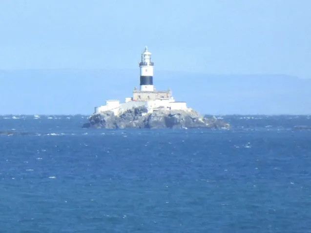
The Maidens
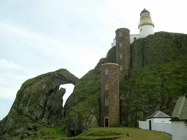
The Maidens — island in United Kingdom.

Wikimedia Commons contributors — see linked file page for photographer and licence licence
Plan your visit
- Typical visit
- 4 h–12 h
- Nearest railway station
- Carnfunnock Family Fun Zone Miniature Railway · 8.6 km
- Dog-friendly
About
The Maidens is a island in the United Kingdom. Wikidata describes it as: "island in United Kingdom". Coordinates: 54.9289°, -5.7278°.
Photo gallery
From the Wikipedia article
The Maidens (Irish: Na Maighdeanacha) or Hulin Rocks (Irish: Na Faoilinn, meaning 'the seagulls') are two islets and several skerries in the North Channel off County Antrim in Northern Ireland. The Eastern Maiden or Southern Rock lies about 9 km from the coast at Ballygalley, or 13 miles from Larne. The West Maiden or Northern Rock is about half a mile further out. Lighthouses were built on both rocks; the West Maiden was abandoned in 1903 and the East Maiden was automated in 1977.
Excerpt from Wikipedia under CC BY-SA 4.0. See the source article linked in Sources below.
- Coordinates
- 54.9289, -5.7278
- Nearest railway station
- Carnfunnock Family Fun Zone Miniature Railway — 8.6 km
Sources
- wikidata: Q3776778 (CC0)
- wikipedia: The Maidens (CC BY-SA 4.0)
- commons: Ancien phare des Maidens.jpg (CC BY-SA 4.0)
Other places nearby
Loading nearby places…
Nearby
 📷 3
📷 3Lighthouses · Northern Ireland
The Maidens lighthouses
The Maidens lighthouses — lighthouse in Northern Ireland.
 📷 3
📷 3Burial mounds & barrows · Northern Ireland
Cairncastle
Cairncastle — a burial mound in northern-ireland, United Kingdom.
📷 3Public art & sculpture · Northern Ireland
The Ballygally Resident Polar Bear
The Ballygally Resident Polar Bear — a public art in northern-ireland, United Kingdom.
 📷 3
📷 3Public art & sculpture · Northern Ireland
Giant Bird Table
Giant Bird Table — a public art in northern-ireland, United Kingdom.
 📷 3
📷 3Theme parks · Northern Ireland
Carnfunnock Family Fun Zone
Carnfunnock Family Fun Zone — a theme park in northern-ireland, United Kingdom.
📷 3Miniature railways · Northern Ireland
Carnfunnock Family Fun Zone Miniature Railway
Carnfunnock Family Fun Zone Miniature Railway — a miniature railway in northern-ireland, United Kingdom.
More places in this region
 📷 3
📷 3Islands · Northern Ireland
Derrywarragh Island
Derrywarragh Island — island in County Armagh, Northern Ireland, United Kingdom.
 📷 3
📷 3Islands · Northern Ireland
Devenish Island
Devenish Island — island in Lower Lough Erne, Northern Ireland.
 📷 3
📷 3Islands · Northern Ireland
Rathlin Island
Rathlin Island — island in County Antrim, Northern Ireland, UK.
 📷 3
📷 3Islands · Northern Ireland
Sanda Island
Sanda Island — a small island in Argyll and Bute, Scotland, UK.
Frequently asked questions
- Where is The Maidens?
- The Maidens is in Northern Ireland, in the United Kingdom — coordinates 54.9289°, -5.7278°. The nearest railway station is Carnfunnock Family Fun Zone Miniature Railway, around 8.6 km away.