
Natural landmarks · East Midlands
The Deepings School
In or near Marholm.
The Deepings School — a school heritage in england-london, United Kingdom.

Bob Harvey — CC BY-SA 2.0 via Wikimedia Commons licence

Plan your visit
- Typical visit
- 1 h–2 h
- Free entry
- Dog-friendly
About
The Deepings School is a school heritage located in england-london, United Kingdom. Catalogued from Wikidata's UK heritage register; see the Wikipedia article for further historical and visitor details.
Photo gallery
Place summary
The Deepings School is located in London. It is an educational institution, serving the local community with a focus on comprehensive education. Further details about its architectural significance or historical context are not provided.
AI-generated from the structured facts on this page (operator, designation, listing, era). Not a substitute for visiting.
Background
Architecture
Admissions rose to 360, with the addition of a rural science block, built away from the main building, to teach soil study and vegetable growing, and greenhouse cultivation. In 1990 a new library and sixth form centre was built, opened in 1991. A language and mathematics block was built in 1997, and a drama studio in 1998. On Monday 8 July 1991 at around 4am, two people, aged 16, who previously attended the school, deliberately set fire to the science block, destroying the office of the head of upper school. 18 firemen attended from Market Deeping, Bourne and Crowland. In February 1992 at Peterborough Court, Matthew Bolton received six months, and Lee Markey received a 200-hour community…
Sourced from Wikipedia under CC BY-SA 4.0.
- Coordinates
- 52.6748, -0.2969
- County
- Lincolnshire
- District
- South Kesteven
- Parish
- Deeping St James
- Postcode
- PE6 8TJ
- Parliamentary constituency
- South Holland and The Deepings
- Established
- 1958
- Official site
- www.deepingschool.org.uk
Sources
- wikidata: Q7729560 (CC0)
- wikipedia: The Deepings School (CC BY-SA 4.0)
Other places nearby
Deeping St James
Historic churches · 0.4 km

Deeping Gate Bridge
Historic bridges · 0.5 km

Deeping St James Priory
Historic churches · 0.6 km

Deeping Saint James
Villages · 0.6 km

Bridge Over Drain To North West Of Giddons Drove
Historic bridges · 1.3 km

Bridge Over Drain About 420 Yards South South East Of Overdale
Historic bridges · 1.3 km

Market Deeping
Museums · 1.4 km
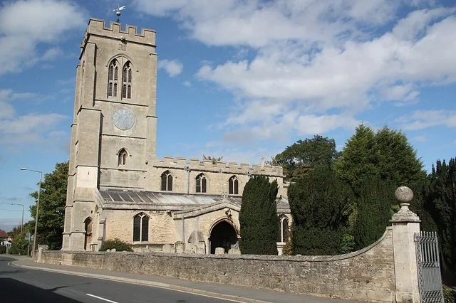
St Guthlac's Church, Market Deeping
Historic churches · 1.6 km

Roman site, Priors Meadow
Archaeological sites · 1.7 km

Mill Race Bridge To Market Deeping Mill
Historic bridges · 1.8 km

The Gate House And Stable Range To North Of Northborough Manor House
Manor houses · 2.1 km
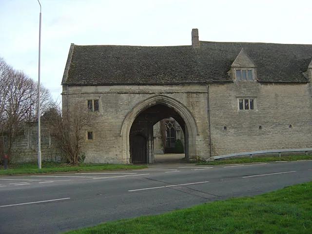
Northborough Manor House
Castles · 2.1 km
Nearby
📷 5Historic churches · East Midlands
Deeping St James
Deeping St James — a church in england-london, United Kingdom.
📷 5Historic bridges · East Midlands
Deeping Gate Bridge
Deeping Gate Bridge — scheduled monument-listed bridge in england-london, United Kingdom.
📷 5Historic churches · East Midlands
Deeping St James Priory
Deeping St James Priory — a church in england-london, United Kingdom.
📷 5📷 5Historic bridges · East Midlands
Bridge Over Drain To North West Of Giddons Drove
Bridge Over Drain To North West Of Giddons Drove — Grade II listed building-listed bridge in england-london, United Kingdom.
📷 5Historic bridges · East Midlands
Bridge Over Drain About 420 Yards South South East Of Overdale
Bridge Over Drain About 420 Yards South South East Of Overdale — Grade II listed building-listed bridge in england-london, United Kingdom.
Where to eat & stay near The Deepings School
Places to stay
 📷 4
📷 4Caravan parks · East Midlands
Home Farm Camping and Caravaning
Home Farm Camping and Caravaning — a caravan park in england east midlands.
 📷 5
📷 5Caravan parks · East Midlands
Cresslands
Cresslands — a caravan park in england east midlands.
 📷 5
📷 5Caravan parks · East Midlands
Windmill Farm Caravan Park
Windmill Farm Caravan Park — a caravan park in england east midlands.
 📷 7
📷 7Hotels · East Midlands
The Angel Hotel
The Angel Hotel — a hotel in england east midlands.
 📷 5
📷 5Campsites · East of England
Sacrewell Farm
Sacrewell Farm — a campsite in england london.
 📷 7
📷 7Places to eat & drink
 📷 5
📷 5Historic pubs · East of England
The Blue Bell Public House
The Blue Bell Public House in England East, United Kingdom.
 📷 5
📷 5Historic pubs · East of England
Blue Bell Public House
Blue Bell Public House in England East, United Kingdom.
 📷 5
📷 5Historic pubs · East of England
Ye Olde White Hart
Ye Olde White Hart in England East, United Kingdom.
 📷 5
📷 5Historic pubs · East Midlands
The George And Angel Public House
The George And Angel Public House in England East, United Kingdom.
 📷 5
📷 5 📷 5
📷 5Restaurants · East of England
The Banyan Tree
The Banyan Tree — a restaurant in england london.
More natural landmarks in this region
 📷 5
📷 5Natural landmarks · East Midlands
The Cage
The Cage — a other in england-london, United Kingdom.
 📷 5
📷 5Natural landmarks · East Midlands
Roman Sea Bank
Roman Sea Bank — a other in england-london, United Kingdom.
 📷 5
📷 5Natural landmarks · East Midlands
The Stamford Spa
The Stamford Spa — a other in england-london, United Kingdom.
 📷 5
📷 5Natural landmarks · East Midlands
John Clare's grave
John Clare's grave — a other in england-london, United Kingdom.
Frequently asked questions
- Where is The Deepings School?
- The Deepings School is in Lincolnshire, London, United Kingdom (postcode PE6 8TJ), in the parish of Deeping St James.
- What is The Deepings School?
- The Deepings School — a school heritage in england-london, United Kingdom.
- How do I get to The Deepings School?
- Drivers can use postcode PE6 8TJ.
- When was The Deepings School built?
- Built or established in 1958.
- Is The Deepings School free to visit?
- Yes, The Deepings School is free to enter.
- How do I get to The Deepings School?
- Drivers can navigate to postcode PE6 8TJ. It sits within the South Holland and The Deepings parliamentary constituency.