Natural landmarks · South East England
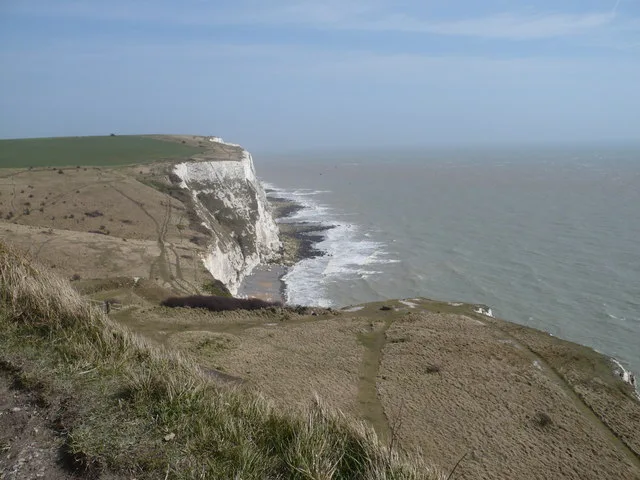
The White Cliffs of Dover
In or near Martin Mill.
Chalk cliffs facing the narrowest part of the English Channel.

Chris Whippet — CC BY-SA 2.0 via Wikimedia Commons licence
Plan your visit
- Typical visit
- 1 h–2 h
- Nearest railway station
- Dover Priory · 2.5 km
- Free entry
- Dog-friendly
Getting there & planning your visit
To visit The White Cliffs of Dover, the nearest railway station is Dover Priory, which is 2.5 km away. The postcode for sat-nav is CT16 1HJ. Entry to the site is free.
About
The White Cliffs of Dover are the chalk cliffs that face the narrowest crossing of the English Channel — the closest part of England to mainland Europe. The cliffs reach 110 metres at their highest, are about 10 miles long, and have been a symbolic image of Britain since at least the medieval era. Owned and managed by the National Trust along the eastern stretch; the South Foreland Lighthouse and Fan Bay Deep Shelter (a WWII tunnel complex) sit on top.
Photo gallery
See it from the streetimagery from 2025
Imagery © Mapillary contributors, CC BY-SA 4.0
Protected designations
- Site of Special Scientific Interest: Dover to Kingsdown Cliffs SSSI
- Area of Outstanding Natural Beauty: Kent Downs
Designations sourced from Natural England open data under OGL v3.
From the Wikipedia article
The White Cliffs of Dover are the region of English coastline facing the Strait of Dover and France. The cliff face, which reaches a height of 350 feet (110 m), owes its striking appearance to its composition of chalk accented by streaks of black flint, deposited during the Late Cretaceous. The cliffs, on both sides of the town of Dover in Kent, stretch for eight miles (13 km). The White Cliffs of Dover form part of the North Downs. The cliffs are part of the Dover to Kingsdown Cliffs Site of Special Scientific Interest and Special Area of Conservation. The top of the cliffs hosts a chalk grassland ecosystem with an abundance of bird, flower, and butterfly species. The cliffs mark the point where Great Britain is closest to continental Europe; on a clear day the cliffs are visible from France, approximately 20 miles (32 km) away. A celebrated UK landmark, their striking appearance has met visitors since ancient times. Julius Caesar remarked upon their appearance when he invaded Britain in 55 BC. The cliffs served as a natural defensive barrier, reinforced by the building of Dover Castle in the 11th century. The cliffs gained symbolic importance during World War II, as a symbol of Britain's resolute defense and as a welcome sight for the evacuees from Dunkirk.
Excerpt from Wikipedia under CC BY-SA 4.0. See the source article linked in Sources below.
Background
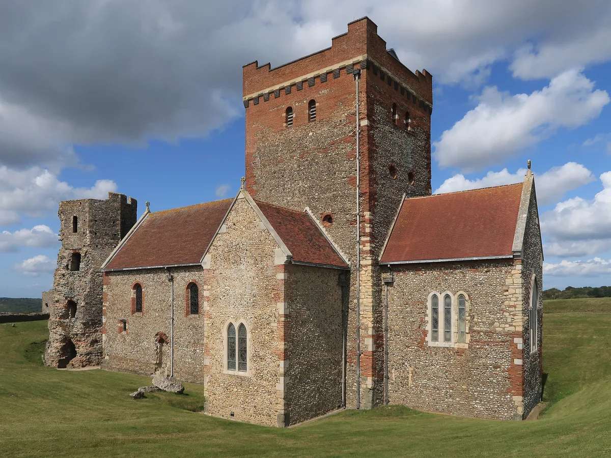
History
In 55 BC, in the earliest recorded mention of the cliffs, Julius Caesar described them in his "Commentarii de Bello Gallico" as rising steeply from the sea and defended by armed Britons, preventing his forces from landing. A possible Iron Age hillfort has been discovered at Dover, on the site of the later castle. The area was also inhabited during the Roman period when Dover was used as a port. A lighthouse survives from this era, one of a pair at Dover which helped shipping navigate the port. It is likely the area around the surviving lighthouse was inhabited in the early medieval period as archaeologists have found a Saxon cemetery here, and the church of St Mary in Castro was built next…
Sourced from Wikipedia under CC BY-SA 4.0.
- Coordinates
- 51.1300, 1.3400
- County
- Kent
- District
- Dover
- Parish
- Guston
- Postcode
- CT16 1HJ
- Parliamentary constituency
- Dover and Deal
- Nearest railway station
- Dover Priory — 2.5 km
Sources
- manual: the-cliffs-of-dover (manual)
- wikipedia: White Cliffs of Dover (CC BY-SA 4.0)
Featured in these 6 guides
Itinerary
Iconic Britain: a 7-day greatest-hits tour
Stonehenge, Bath, Edinburgh, Hadrian's Wall, the Lake District, Snowdonia, London.
Itinerary
Britain's white cliffs & sea stacks
Ten dramatic chalk and sandstone coastal landmarks.
Itinerary
Isle of Wight weekend
The Needles, Osborne House, and Britain's dinosaur coast.
Itinerary
Britain's best winter walks
Crisp-frost trails for December and January.
Itinerary
Britain's May-blossom walks
Hawthorn, blackthorn, cherry — late spring at peak.
Itinerary
National Trust's best coastal properties
Beach access, cliff walks and Victorian beach piers.
Cinematic fly-through
Rendered from Environment Agency LIDAR (OGL v3) using Blender. Drag the timeline to scrub.
3D view
Drag to rotate · scroll to zoom · Copernicus DEM 30m / European Space Agency (CC BY 4.0)
Other places nearby

National Trust White Cliffs of Dover
Natural landmarks · 0.2 km

Langdon Bay
Natural landmarks · 0.6 km

Langdon Beach
Beaches · 0.8 km
Langdon Bay, Kent
Mountains & hills · 0.9 km

SS Falcon
Museums · 0.9 km

White Cliffs of Dover
Natural landmarks · 1.0 km

Bleriot Memorial
Memorials & monuments · 1.0 km

Crab Bay
Natural landmarks · 1.1 km
St Mary sub Castro, Dover
Historic churches · 1.1 km
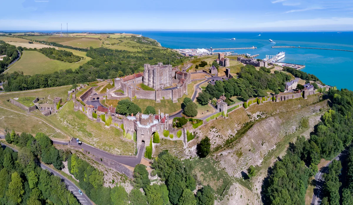
Dover Castle
Castles · 1.2 km

Admiral Ramsay
Memorials & monuments · 1.2 km

Dubris
Hill forts · 1.2 km
Nearby
📷 5Natural landmarks · South East England
National Trust White Cliffs of Dover
National Trust White Cliffs of Dover — a natural landmark in england-south-east, United Kingdom.
📷 5Natural landmarks · South East England
Langdon Bay
Langdon Bay — a natural feature in england south east.
📷 5📷 5Mountains & hills · South East England
Langdon Bay, Kent
Langdon Bay, Kent — bay in Kent, England.
📷 5📷 5Natural landmarks · South East England
White Cliffs of Dover
White Cliffs of Dover — a natural landmark in england-south-east, United Kingdom.
Where to eat & stay near The White Cliffs of Dover
Places to stay
 📷 5
📷 5B&Bs · South East England
Churchill
Churchill — a bed-and-breakfast in england south east.
 📷 5
📷 5 📷 5
📷 5Caravan parks · South East England
St Margarets Bay Holiday Park
St Margarets Bay Holiday Park — a caravan park in england south east. Brand: Parkdean Resorts.
 📷 5
📷 5Campsites · South East England
Hawthorn Farm (Keat farm)
Hawthorn Farm (Keat farm) — a campsite in england south east.
 📷 5
📷 5 📷 5
📷 5Campsites · South East England
Kingsdown International Camping Centre
Kingsdown International Camping Centre — a campsite in england south east.
Places to eat & drink
 📷 7
📷 7Restaurants · South East England
The Swingate Inn, Namaste Curry House
The Swingate Inn, Namaste Curry House — a restaurant in england south east. Cuisine: indian.
 📷 7
📷 7 📷 7
📷 7Restaurants · South East England
81 Beach Street
81 Beach Street — a restaurant in england south east.
 📷 5
📷 5Historic pubs · South East England
The Martello Public House
The Martello Public House in England South East, United Kingdom.
 📷 5
📷 5Historic pubs · South East England
The Samuel Peto
The Samuel Peto in England South East, United Kingdom.
 📷 5
📷 5Historic pubs · South East England
The Black Pig Inn
The Black Pig Inn in England South East, United Kingdom.
More natural landmarks in this region
 📷 5
📷 5Natural landmarks · South East England
Queen Victoria Statue
Queen Victoria Statue — Public artwork (statue) by Victor Ferdinand Franz Eugen Gustaf Adolf Constantin Friedrich of Hohenlohe-Langenburg.
 📷 5
📷 5Natural landmarks · South East England
Silent Pool
Silent Pool — lake in the United Kingdom.
 📷 5
📷 5Natural landmarks · South East England
Thomas & Jane Holloway Statue
Thomas & Jane Holloway Statue — Public artwork (statue) by Victor Ferdinand Franz Eugen Gustaf Adolf Constantin Friedrich of Hohenlohe-Langenburg.
 📷 5
📷 5Natural landmarks · South East England
Polesden Lacey
Polesden Lacey — a other in england-london, United Kingdom.
Frequently asked questions
- Where is The White Cliffs of Dover?
- The White Cliffs of Dover is in Kent, South-East England, United Kingdom (postcode CT16 1HJ), in the parish of Guston.
- What is The White Cliffs of Dover?
- Chalk cliffs facing the narrowest part of the English Channel.
- How do I get to The White Cliffs of Dover?
- The nearest railway station is Dover Priory, about 2.5 km away. Drivers can use postcode CT16 1HJ.
- Is The White Cliffs of Dover a protected site?
- Yes — The White Cliffs of Dover is part of the Dover to Kingsdown Cliffs SSSI Site of Special Scientific Interest and the Kent Downs National Landscape (AONB).
- Is The White Cliffs of Dover free to visit?
- Yes, The White Cliffs of Dover is free to enter.
- How do I get to The White Cliffs of Dover?
- The nearest railway station is Dover Priory, about 2.5 km away. Drivers can navigate to postcode CT16 1HJ.