
Historic houses · South East England
The Bell Inn
In or near Aldworth.
The Bell Inn — a Grade II*-listed historic house in england-south-east, United Kingdom.

Oscar Taylor — CC BY-SA 2.0 via Wikimedia Commons licence

Plan your visit
- Typical visit
- 1 h–2 h
- Nearest railway station
- Goring & Streatley · 4.8 km
- Family-friendly
- Limited wheelchair access
Getting there & planning your visit
To visit The Bell Inn, the nearest railway station is Goring & Streatley, located 4.8 km away. The postcode for sat-nav is RG8 9SE. Please note that wheelchair accessibility is limited.
About
The Bell Inn is a Grade II*-listed building in england-south-east, United Kingdom. Grade II* status is conferred by Historic England (or Cadw, Historic Environment Scotland or NIEA equivalents) on buildings of exceptional national interest. See the linked Wikipedia article for full historical and architectural details.
Photo gallery
Protected designations
- Area of Outstanding Natural Beauty: North Wessex Downs
Designations sourced from Natural England open data under OGL v3.
From the Wikipedia article
The Bell Inn is a pub at the village of Aldworth, in the English county of West Berkshire. It won CAMRA's National Pub of the Year in 1990, and received the accolade again for 2019. It is a Grade II listed building and is the only pub in Berkshire with a Grade II listed interior. It is also on the Campaign for Real Ale's National Inventory of Historic Pub Interiors. The pub is built of brick with a timber frame, and is said to have once been a medieval hall house or manor house before it became a pub. It was built in the 15th century or possibly earlier, with C17 and C19 alterations and a C20 addition. It has two rooms, a large panelled tap room with inglenook fireplace and quarry-tiled floor, and a smaller L-shaped room. The bar itself is a servery with sliding glass partitions and hatches, and has no bar fittings at all save for ebony handpumps, which were fitted in 1902. Besides its listing and awards, the pub is also notable for having been owned and run by the same family continuously since the 18th century. The pub is a free house and sells beers from a number of local breweries, as well as its famous filled rolls. It is popular with locals, as well as walkers on the nearby Ridgeway.
Excerpt from Wikipedia under CC BY-SA 4.0. See the source article linked in Sources below.
- Coordinates
- 51.5132, -1.2006
- District
- West Berkshire
- Parish
- Aldworth
- Postcode
- RG8 9SE
- Parliamentary constituency
- Reading West and Mid Berkshire
- Nearest railway station
- Goring & Streatley — 4.8 km
Sources
- wikidata: Q17985824 (CC0)
- wikipedia: The Bell Inn, Aldworth (CC BY-SA 4.0)
Other places nearby

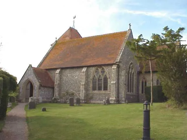
St Mary's church, Aldworth
Historic churches · 0.3 km
Aldworth
Towns & cities · 0.5 km

Warren Hill
Mountains & hills · 1.9 km

Thurle Down
Mountains & hills · 2.5 km

Ashampstead
Towns & cities · 2.7 km

Goring and Streatley Golf Club
Golf courses · 2.8 km

Tower Approximately 70 Metres To North Of Blorenge House
Memorials & monuments · 2.8 km

Lowbury Hill
Archaeological sites · 3.0 km

Lowbury Hill
Archaeological sites · 3.0 km

Lowbury Hill
Mountains & hills · 3.1 km

Lingley Knoll
Mountains & hills · 3.5 km

The Living Rain Forest
Zoos & aquariums · 3.7 km
Nearby
📷 5Historic churches · South East England
St Mary's church, Aldworth
St Mary's church, Aldworth — Grade I listed building-listed church in england-south-east, United Kingdom.
Flagship📷 10Towns & cities · South East England
Aldworth
Aldworth — village and civil parish in the English county of Berkshire.
📷 5Mountains & hills · South East England
Warren Hill
Warren Hill — a hill or mountain in england south east.
📷 5Mountains & hills · South East England
Thurle Down
Thurle Down — mountain in england south east. Elevation: 155 m.
📷 5Towns & cities · South East England
Ashampstead
Ashampstead — village in Berkshire, England, UK.
📷 5Golf courses · South East England
Goring and Streatley Golf Club
Goring and Streatley Golf Club — Golf course in Berkshire, England.
Where to eat & stay near The Bell Inn
Places to stay
 📷 5
📷 5 📷 5📷 5
Campsites · South East England
Braziers Park Campsite
Braziers Park Campsite — a campsite in england south east.
📷 5📷 5 📷 5
📷 5Places to eat & drink
 📷 7
📷 7Historic pubs · South East England
The Bull Hotel
The Bull Hotel in England South East, United Kingdom.
 📷 5
📷 5Historic pubs · South East England
The Catherine Wheel Public House
The Catherine Wheel Public House in England South East, United Kingdom.
 📷 7
📷 7Historic pubs · South East England
The Old Tavern
The Old Tavern in England South East, United Kingdom.
 📷 5
📷 5 📷 7
📷 7Historic pubs · South East England
The Chequers Inn Public House
The Chequers Inn Public House in England South East, United Kingdom.
 📷 5
📷 5Historic pubs · South East England
Fleur De Lys Public House
Fleur De Lys Public House in England South East, United Kingdom.
More historic houses in this region
 📷 5
📷 5Historic houses · South East England
12 and 14 High Street, Rochester
12 and 14 High Street, Rochester — building in Rochester, Kent, England, UK.
 📷 5
📷 5Historic houses · South East England
Berkeley House
Berkeley House — house in Rochester, Kent, England, UK.
.jpg?width=1200) 📷 5
📷 5Historic houses · South East England
Betchworth House
Betchworth House — house in Betchworth, Mole Valley, England, UK.
 📷 5
📷 5Historic houses · South East England
Bookham Grove
Bookham Grove — building in Mole Valley, Surrey, England, UK.
Frequently asked questions
- Where is The Bell Inn?
- The Bell Inn is in South-East England, United Kingdom (postcode RG8 9SE), in the parish of Aldworth.
- What is The Bell Inn?
- The Bell Inn — a Grade II*-listed historic house in england-south-east, United Kingdom.
- How do I get to The Bell Inn?
- The nearest railway station is Goring & Streatley, about 4.8 km away. Drivers can use postcode RG8 9SE.
- Who owns The Bell Inn?
- The Bell Inn is owned by | current_tenants =.
- Is The Bell Inn a listed building?
- The Bell Inn is officially recognised as Grade II* listed.
- Is The Bell Inn a protected site?
- Yes — The Bell Inn is part of the North Wessex Downs National Landscape (AONB).
- How do I get to The Bell Inn?
- The nearest railway station is Goring & Streatley, about 4.8 km away. Drivers can navigate to postcode RG8 9SE.