
Castles · North East England
The Bailey
In or near Durham.
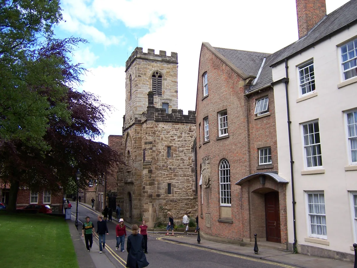
The Bailey in England North East, United Kingdom.

John Sutton — CC BY-SA 2.0 via Wikimedia Commons licence

Plan your visit
- Typical visit
- 1.5 h–3 h
- Nearest railway station
- Durham · 0.9 km
- Paid entry
- Family-friendly
- Wheelchair accessible
Getting there & planning your visit
The Bailey is located in County Durham, postcode DH1 3EW, and is accessible via the nearest railway station, Durham, which is 0.9 km away. Entry details are not specified, but the site is wheelchair accessible.
About
The Bailey is a place of interest in England North East, United Kingdom — drawn from open-data sources for visitor reference. See the linked Wikipedia article for the full description.
Photo gallery
360° viewimagery from 2018
Imagery © Mapillary contributors, CC BY-SA 4.0
Official information
Durham Cathedral Museum is located within the medieval monastery of Durham and showcases a variety of historical artifacts and stories. Visitors can see significant items such as St Cuthbert's cross and coffin, as well as early Christian stonework and treasures from St Cuthbert's shrine.
From the Wikipedia article
The Bailey is a historic area in the centre of the city of Durham, County Durham, England. It consists of two streets, North Bailey and South Bailey. It is on a peninsula within a sharp meander along the River Wear, formed by an isostatic adjustment of the land. The name "The Bailey" derives from the outer bailey of the Norman motte and bailey-style Durham Castle. Vehicular access to the area is restricted by the Durham City congestion charge, which started in 2002 and is the UK's oldest such scheme.
Excerpt from Wikipedia under CC BY-SA 4.0. See the source article linked in Sources below.
Background
History
With steep cliffs and the River Wear on three sides, Durham's peninsula has long been recognised as a prime defensive site. A fortress was first established there in 1072, with the present keep being built in the 14th century. In the Middle Ages the whole peninsula was known as "the castle" and was enclosed by a wall. Parts of the wall can still be seen in the grounds of the Bailey colleges of Durham University and to the west of the Cathedral; these walls are Grade I listed. Along the inside of the wall on the east side ran a street. This road still exists and forms the present North and South Bailey. The central and southern parts of the peninsula, including the Castle, the Cathedral, the…
Sourced from Wikipedia under CC BY-SA 4.0.
- Coordinates
- 54.7728, -1.5753
- District
- County Durham
- Parish
- City of Durham
- Postcode
- DH1 3EW
- Parliamentary constituency
- City of Durham
- Nearest railway station
- Durham — 0.9 km
- Opening
- Monday - Saturday 10am - 4pm; Sunday 12pm - 4pm
- Official site
- www.durhamcathedral.co.uk
Sources
- wikidata: Q7715344 (CC0)
- wikipedia: The Bailey (CC BY-SA 4.0)
Other places nearby
Bailey college
Natural landmarks · 0.0 km
_07.jpg?width=1200)
Langford House
Historic houses · 0.0 km
St Chad's College
Historic churches · 0.0 km
Ramsey House
Historic houses · 0.0 km
William Greenwell
Memorials & monuments · 0.0 km

Cranmer Hall, Durham
Historic churches · 0.1 km

Durham War Memorial
Memorials & monuments · 0.1 km
_39.jpg?width=1200)
Castle Wall Behind Nos. 16-22 And No.22a (st. Chad's)
Holy wells · 0.1 km

Durham Cathedral
Cathedrals · 0.1 km
Durham Museum
Museums · 0.1 km

Durham Museum, Durham
Museums · 0.1 km

St John's College
Historic churches · 0.1 km
Nearby
📷 3Natural landmarks · North East England
Bailey college
Bailey college in England North East, United Kingdom.
📷 3Historic houses · North East England
Langford House
Langford House — building in Durham, England, UK.
📷 4Historic churches · North East England
St Chad's College
St Chad's College in England North East, United Kingdom.
📷 3Historic houses · North East England
Ramsey House
Ramsey House in England North East, United Kingdom.
📷 3Memorials & monuments · North East England
William Greenwell
William Greenwell — a memorial in scotland-lowlands, United Kingdom.
📷 4Historic churches · North East England
Cranmer Hall, Durham
Cranmer Hall, Durham in England North East, United Kingdom.
Where to eat & stay near The Bailey
Places to stay
 📷 5
📷 5Hotels · North East England
Durham Marriott Hotel Royal County
Durham Marriott Hotel Royal County — a hotel in scotland lowlands.
 📷 5
📷 5Hotels · North East England
Hotel Indigo Durham
Hotel Indigo Durham — a hotel in scotland lowlands.
 📷 5
📷 5B&Bs · North East England
Castle View Guest House
Castle View Guest House — a bed-and-breakfast in scotland lowlands.
 📷 5
📷 5B&Bs · North East England
The Georgian Town House
The Georgian Town House — a bed-and-breakfast in scotland lowlands.
 📷 5
📷 5Hotels · North East England
Radisson Blu
Radisson Blu — a hotel in scotland lowlands.
 📷 5
📷 5Campsites · North East England
Durham Amateur Rowing Club
Durham Amateur Rowing Club — a campsite in scotland lowlands.
Places to eat & drink
 📷 7
📷 7Restaurants · North East England
Shaheen's Indian
Shaheen's Indian — a restaurant in scotland lowlands.
 📷 4
📷 4Historic pubs · North East England
The Victoria
The Victoria in England North East, United Kingdom.
 📷 5📷 6
Cafés · North East England
Flat White Kitchen
Flat White Kitchen — a café in scotland lowlands.
 📷 7
📷 7Restaurants · North East England
Fat Hippo
Fat Hippo — a restaurant in scotland lowlands.
 📷 6
📷 6More castles in this region
 📷 3
📷 3Castles · North East England
Scargill Castle
Scargill Castle — house in Scargill, County Durham, England, UK.
 📷 3
📷 3Castles · North East England
Roper Castle or Round Table (Roman Signal Station)
Roper Castle or Round Table (Roman Signal Station) — a castle in england-north-west, United Kingdom.
 📷 5
📷 5 📷 5
📷 5Castles · North East England
Appleby Castle
Appleby Castle — Grade I listed English country house in Appleby-in-Westmorland, United Kingdom.
Frequently asked questions
- Where is The Bailey?
- The Bailey is in North-East England, United Kingdom (postcode DH1 3EW), in the parish of City of Durham.
- What is The Bailey?
- The Bailey in England North East, United Kingdom.
- How do I get to The Bailey?
- The nearest railway station is Durham, about 0.9 km away. Drivers can use postcode DH1 3EW.
- Does The Bailey charge admission?
- The Bailey typically charges admission. Check the official site for current ticket prices and opening hours.
- How do I get to The Bailey?
- The nearest railway station is Durham, about 0.9 km away. Drivers can navigate to postcode DH1 3EW.