
Archaeological sites · North Wales
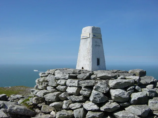
Telegraph Signal Station
In or near Trearddur.
Telegraph Signal Station — a archaeological in wales-north, United Kingdom.

Eric Jones — CC BY-SA 2.0 via Wikimedia Commons licence

Plan your visit
- Typical visit
- 45 min–1.5 h
- Nearest railway station
- Holyhead · 3.3 km
- Free entry
- Dog-friendly
About
Telegraph Signal Station is a archaeological located in wales-north, United Kingdom. Sourced from OpenStreetMap (ODbL licence); see local listings for visitor information, opening hours and admission details.
Photo gallery
Place summary
The Telegraph Signal Station is an archaeological site located in North Wales. It was used for communication via semaphore signals, playing a significant role in maritime signalling. The site reflects the historical importance of communication technology in the region.
AI-generated from the structured facts on this page (operator, designation, listing, era). Not a substitute for visiting.
- Coordinates
- 53.3175, -4.6781
- District
- Isle of Anglesey
- Parish
- Holyhead
- Postcode
- LL65 1YG
- Parliamentary constituency
- Ynys Môn
- Nearest railway station
- Holyhead — 3.3 km
Sources
- osm: node/1243679980 (ODbL)
Other places nearby

Caer y Twr Hillfort
Hill forts · 0.5 km

Holyhead Mountain
Mountains & hills · 0.5 km
Mynydd Twr
Mountains & hills · 0.5 km

Gogarth Bay
Natural landmarks · 0.5 km

Parliament House Cave
Caves · 0.6 km
%2C_Ynys_Mon%2C_Wales_07.jpg?width=1200)
North Stack
Islands · 0.7 km

Capel Llochwydd (ruined)
Archaeological sites · 0.7 km

Llaingoch
Historic churches · 1.1 km

Bronze Hoard found A.D. 1832
Archaeological sites · 1.1 km

Tŷ Mawr Hut Circles (Northeast Group)
Archaeological sites · 1.3 km

Tŷ Mawr Hut Circles
Archaeological sites · 1.5 km

Ty Mawr Farm Campsite
Campsites · 1.7 km
Nearby
📷 3Hill forts · North Wales
Caer y Twr Hillfort
Caer y Twr Hillfort — a hill fort in wales-north, United Kingdom.
📷 5Mountains & hills · North Wales
Holyhead Mountain
Holyhead Mountain — a hill or mountain in wales north.
📷 4📷 5📷 5Caves · North Wales
Parliament House Cave
Parliament House Cave — cave in wales north. Elevation: 0 m.
📷 5Where to eat & stay near Telegraph Signal Station
Places to stay
📷 5Campsites · North Wales
Ty Mawr Farm Campsite
Ty Mawr Farm Campsite — a campsite in wales north.
 📷 5
📷 5Campsites · North Wales
Blackthorn Farm Campsite
Blackthorn Farm Campsite — a campsite in wales north.
📷 5Caravan parks · North Wales
Blackthorn Farm Caravan Park
Blackthorn Farm Caravan Park — a caravan park in wales north.
📷 5 📷 5
📷 5Caravan parks · North Wales
Valley Of The Rocks Caravan Park
Valley Of The Rocks Caravan Park — a caravan park in wales north.
📷 5Campsites · North Wales
Valley Of The Rocks Campsite
Valley Of The Rocks Campsite — a campsite in wales north.
Places to eat & drink
 📷 5
📷 5Restaurants · North Wales
Oyster Catcher
Oyster Catcher — a restaurant in wales north.
 📷 5
📷 5Historic pubs · North Wales
The Kings Head Hotel
The Kings Head Hotel in Wales North, United Kingdom.
More archaeological sites in this region
 📷 3
📷 3Archaeological sites · North Wales
Coed-y-Brenin
Coed-y-Brenin is a archaeological site in the United Kingdom.
 📷 3
📷 3Archaeological sites · North Wales
Gwydir Forest
Gwydir Forest — forest in Conwy County Borough, Wales.
 📷 3
📷 3Archaeological sites · North Wales
Newborough Forest
Newborough Forest — forest in Anglesey, North Wales.
 📷 4
📷 4Archaeological sites · North Wales
Canovium
Canovium was a fort in the Roman province of Britannia. Its site is located at Caerhun in the Conwy valley, in the county borough of Conwy, in North Wales.
Frequently asked questions
- Where is Telegraph Signal Station?
- Telegraph Signal Station is in North Wales, United Kingdom (postcode LL65 1YG), in the parish of Holyhead.
- What is Telegraph Signal Station?
- Telegraph Signal Station — a archaeological in wales-north, United Kingdom.
- How do I get to Telegraph Signal Station?
- The nearest railway station is Holyhead, about 3.3 km away. The nearest town is Trearddur. Drivers can use postcode LL65 1YG.
- Is Telegraph Signal Station free to visit?
- Yes, Telegraph Signal Station is free to enter.
- How do I get to Telegraph Signal Station?
- The nearest railway station is Holyhead, about 3.3 km away. Drivers can navigate to postcode LL65 1YG.