Mountains & hills · North West England
Stone Chair Hill
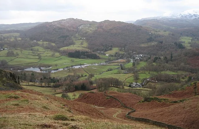
Stone Chair Hill — mountain in england north west. Elevation: 204 m.

David Purchase — CC BY-SA 2.0 via Wikimedia Commons licence
Plan your visit
- Typical visit
- 3 h–8 h
- Best time of year
- Late spring – early autumn (May–Oct)
About
Stone Chair Hill is a mountain located in england north west. Elevation: 204 m. A named British peak recorded in OpenStreetMap. Peaks are typically named on Ordnance Survey 1:50k mapping.
Photo gallery
Place summary
Stone Chair Hill is a mountain located in North-West England. It is noted for its distinctive rock formations and offers scenic views of the surrounding landscape. The area is popular among hikers and outdoor enthusiasts, providing various routes for exploration. Visitors can expect a rugged terrain typical of the region, suitable for those seeking a challenging walk in a natural setting.
AI-generated from the structured facts on this page (operator, designation, listing, era). Not a substitute for visiting.
- Coordinates
- 54.4039, -3.0315
Sources
- osm: n4990559780 (ODbL)
Other places nearby
Loading nearby places…
Nearby
 📷 3
📷 3Mountains & hills · North West England
Black Fell
Black Fell — Named summit at 323 m.
 📷 3
📷 3Natural landmarks · North West England
Black Fell
Black Fell — mountain in United Kingdom.
 📷 5
📷 5Mountains & hills · North West England
Tom Heights
Tom Heights — a hill or mountain in england north west.
📷 5Mountains & hills · North West England
Tom Heights
Tom Heights — mountain in england north west. Elevation: 269 m.
 📷 3
📷 3Natural landmarks · North West England
Yew Tree Tarn
Yew Tree Tarn — lake in Cumbria, United Kingdom.
 📷 5
📷 5Mountains & hills · North West England
Great How
Great How — a hill or mountain in england north west.
Where to eat & stay near Stone Chair Hill
Places to stay
 📷 5
📷 5Caravan parks · North West England
Skelwith Fold Caravan Park
Skelwith Fold Caravan Park — a caravan park in england north west.
 📷 5
📷 5Campsites · North West England
Tarn Foot Farm Campsite
Tarn Foot Farm Campsite — a campsite in england north west.
 📷 5
📷 5Campsites · North West England
Hawkshead Hall Camping & Caravan Site
Hawkshead Hall Camping & Caravan Site — a campsite in england north west.
 📷 5
📷 5Hostels · North West England
Elterwater Hostel
Elterwater Hostel — a hostel in england north west.
 📷 5
📷 5Hotels · North West England
HF Holidays Monk Coniston
HF Holidays Monk Coniston — a hotel in england north west.
 📷 5
📷 5Campsites · North West England
Keen Ground Farm
Keen Ground Farm — a campsite in england north west.
Places to eat & drink
 📷 5
📷 5Historic pubs · North West England
Sun Cottage Sun Inn Public House
Sun Cottage Sun Inn Public House in England North West, United Kingdom.
 📷 5
📷 5Historic pubs · North West England
Golden Rule Hotel
Golden Rule Hotel in England North West, United Kingdom.
 📷 5
📷 5Restaurants · North West England
The Terrace Coffee House and Restaurant
The Terrace Coffee House and Restaurant — a restaurant in england north west. Cuisine: sandwich;lunch.
 📷 5
📷 5Historic pubs · North West England
Holbeck Ghyll
Holbeck Ghyll in England North West, United Kingdom.
📷 5Restaurants · North West England
Holbeck Ghyll Restaurant
Holbeck Ghyll Restaurant — a restaurant in england north west.
 📷 4
📷 4Restaurants · North West England
Holbeck Ghyll
Holbeck Ghyll is a restaurant located in Windermere, Cumbria, England. "The late 19th century building was once Lord Lonsdale's hunting lodge and only became a hotel in the 1970s. It won a Michelin st
More mountains in this region
 📷 3
📷 3Mountains & hills · North West England
Allen Crags
Allen Crags — Named summit at 785 m.
 📷 3
📷 3Mountains & hills · North West England
Alum Pot
Alum Pot — Open shaft pothole in North Yorkshire.
 📷 3
📷 3Mountains & hills · North West England
Arnside Knott
Arnside Knott — Named summit at 159 m.
 📷 3
📷 3Mountains & hills · North West England
Aye Gill Pike
Aye Gill Pike — Named summit at 556.3 m.
Frequently asked questions
- Where is Stone Chair Hill?
- Stone Chair Hill is in North-West England, United Kingdom.
- What is Stone Chair Hill?
- Stone Chair Hill — mountain in england north west. Elevation: 204 m.
- How do I get to Stone Chair Hill?
- Its coordinates are 54.4039°, -3.0315°.