Historic churches · Yorkshire & the Humber
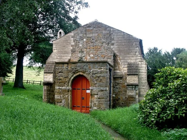
St Mary's Chapel, Lead
St Mary's Chapel, Lead — church in Lead, North Yorkshire, England, UK.

Wikimedia Commons contributors — see linked file page for photographer and licence licence
Plan your visit
- Typical visit
- 30 min–1 h
- Nearest railway station
- Church Fenton · 4.5 km
- Free entry
About
St Mary's Chapel, Lead is a historic church in the United Kingdom. Records date its origin to 1301. Heritage designation: Grade II* listed building. Wikidata describes it as: "church in Lead, North Yorkshire, England, UK". Coordinates: 53.8263°, -1.2963°.
Photo gallery
Heritage listing
St Mary's Church, Lead, is a redundant Anglican chapel standing in an isolated position in fields in the civil parish of Lead, some 0.75 miles (1.2 km) to the west of the village of Saxton, North Yorkshire, England. Though technically a chapel, it is generally referred to as a church. It is managed by The Churches Conservation Trust, and is recorded in the National Heritage List for England as a designated Grade II* listed building. The chapel stands close to the site of the Battle of Towton of 1461, which was part of the Wars of the Roses.
From the Historic England List Entry under OGL v3.
From the Wikipedia article
St Mary's Church, Lead, is a redundant Anglican chapel standing in an isolated position in fields in the civil parish of Lead, some 0.75 miles (1.2 km) to the west of the village of Saxton, North Yorkshire, England. Though technically a chapel, it is generally referred to as a church. It is managed by The Churches Conservation Trust, and is recorded in the National Heritage List for England as a designated Grade II* listed building. The chapel stands close to the site of the Battle of Towton of 1461, which was part of the Wars of the Roses. In the 1930s it was saved from neglect by a local group of ramblers, and is known locally as the Ramblers' Church.
Excerpt from Wikipedia under CC BY-SA 4.0. See the source article linked in Sources below.
Background
History
The chapel dates from the 14th century and was probably the chapel for a medieval manor house which no longer exists. It is thought that it was built for the Tyas family. Additions were made to the chapel in the 18th century. In the late 19th and early 20th centuries repairs to the chapel were carried out, and in 1912 it was incorporated into the parish of Saxton; before this time it had been a chapelry. However, by 1931 it had fallen into ruin, but it was saved by a group of local ramblers. Repairs were carried out, the 18th-century communion rails were removed, the three-decker pulpit was moved into the northeast corner of the chapel, a stone altar was built, and the medieval altar slab…
Architecture
St Mary's is a small chapel, built in stone, some 18 ft long, with a rectangular plan, and a bellcote at the west end. Its interior is very simple, containing benches dating possibly from the medieval period. On the east wall of the chapel are boards containing sentences from the Holy Communion service dating from the 18th century. Also in the chapel are a three-decker pulpit, a stone altar, and a font.
Sourced from Wikipedia under CC BY-SA 4.0.
- Coordinates
- 53.8263, -1.2963
- District
- North Yorkshire
- Parish
- Saxton with Scarthingwell
- Postcode
- LS24 9QN
- Parliamentary constituency
- Wetherby and Easingwold
- Established
- 1301
- Nearest railway station
- Church Fenton — 4.5 km
- Official site
- www.visitchurches.org.uk
Sources
- wikidata: Q7594258 (CC0)
- wikipedia: St Mary's Chapel, Lead (CC BY-SA 4.0)
- commons: St Mary Lead 6828.JPG (CC BY-SA 4.0)
Other places nearby
Loading nearby places…
Nearby
 📷 5
📷 5Historic churches · Yorkshire & the Humber
Church of All Saints
Church of All Saints — historic church in Saxton with Scarthingwell, Selby, North Yorkshire, England, UK.
 📷 5
📷 5Castles · Yorkshire & the Humber
Saxton, North Yorkshire
Saxton, North Yorkshire — a castle in england-yorkshire, United Kingdom.
 📷 3
📷 3Historic houses · Yorkshire & the Humber
Lotherton Hall
Lotherton Hall — a other in england-yorkshire, United Kingdom.
 📷 3
📷 3Chapels · Yorkshire & the Humber
Lotherton Chapel
Lotherton Chapel — chapel in Lotherton cum Aberford, West Yorkshire, England, UK.
 📷 3
📷 3Forts · Yorkshire & the Humber
Battle of Towton
Battle of Towton is a fort in the United Kingdom.
 📷 5
📷 5Historic houses · Yorkshire & the Humber
Dacre's Cross
Dacre's Cross — a Grade II*-listed historic house in england-yorkshire, United Kingdom.
Other places from this era
 📷 5
📷 5Historic churches · London
All Hallows Staining
All Hallows Staining — church in City of London, UK.
 📷 5
📷 5Historic churches · London
All Hallows' Church, Tottenham
All Hallows' Church, Tottenham — church in Tottenham, London.
 📷 5
📷 5Historic churches · London
All Saints Church, Kingston upon Thames
All Saints Church, Kingston upon Thames — church in Kingston upon Thames, London.
 📷 5
📷 5Historic churches · London
All Saints Church, Maidstone
All Saints Church, Maidstone — parish church associated with the Archbishop's Palace, Maidstone, Kent, England, UK.
More places in this region
 📷 3
📷 3Historic churches · Yorkshire & the Humber
All Hallows Church, Clixby
All Hallows Church, Clixby — church in West Lindsey, UK.
 📷 5
📷 5Historic churches · Yorkshire & the Humber
All Saints Church, Normanton
All Saints Church, Normanton — grade II listed church in Normanton, Wakefield, West Yorkshire, England, UK.
 📷 3
📷 3Historic churches · Yorkshire & the Humber
All Saints Church, Thorpe Bassett
All Saints Church, Thorpe Bassett — church in Ryedale, UK.
 📷 5
📷 5Historic churches · Yorkshire & the Humber
All Saints, Pavement
All Saints, Pavement — Grade I listed church in York, Yorkshire, England.
Frequently asked questions
- Where is St Mary's Chapel, Lead?
- St Mary's Chapel, Lead is in Yorkshire, United Kingdom (postcode LS24 9QN), in the parish of Saxton with Scarthingwell.
- When was St Mary's Chapel, Lead built?
- Built or established in 1301.
- Is St Mary's Chapel, Lead a listed building?
- St Mary's Chapel, Lead is officially recognised as Grade II* listed building listed.
- Is St Mary's Chapel, Lead free to visit?
- Yes, St Mary's Chapel, Lead is free to enter.
- How do I get to St Mary's Chapel, Lead?
- The nearest railway station is Church Fenton, about 4.5 km away. Drivers can navigate to postcode LS24 9QN.