
Historic churches · East of England
St Gregory's Church, Heckingham
In or near Chedgrave.
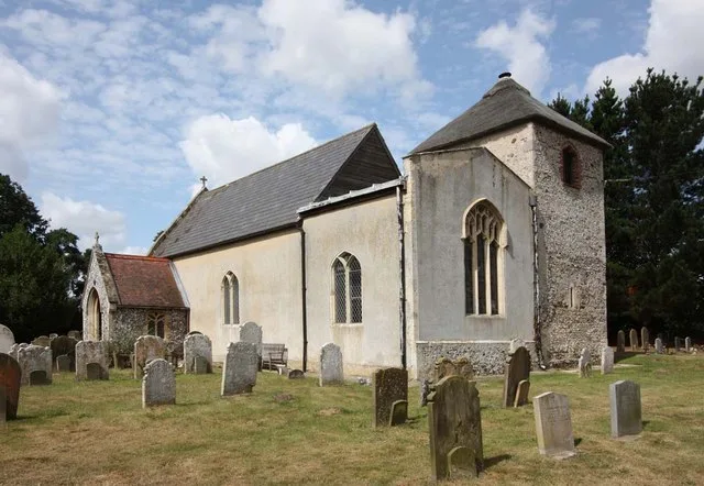
St Gregory's Church, Heckingham — a Grade I-listed church in england-east, United Kingdom.

nick macneill — CC BY-SA 2.0 via Wikimedia Commons licence

Plan your visit
- Typical visit
- 30 min–1 h
- Nearest railway station
- Reedham · 4.5 km
- Free entry
Getting there & planning your visit
To visit St Gregory's Church in Heckingham, the nearest railway station is Reedham, located 4.5 km away. The postcode for sat-nav is NR14 6QT, and entry to the church is free.
About
St Gregory's Church, Heckingham is a Grade I-listed building in england-east, United Kingdom. Grade I status is conferred by Historic England (or Cadw, Historic Environment Scotland or NIEA equivalents) on buildings of exceptional national interest. See the linked Wikipedia article for full historical and architectural details.
Photo gallery
Heritage listing
St Gregory's Church is a redundant Anglican church in the village of Heckingham, Norfolk, England. It is recorded in the National Heritage List for England as a designated Grade I listed building, and is under the care of the Churches Conservation Trust. It stands on a small hill overlooking the River Chet.
From the Historic England List Entry under OGL v3.
From the Wikipedia article
St Gregory's Church is a redundant Anglican church in the village of Heckingham, Norfolk, England. It is recorded in the National Heritage List for England as a designated Grade I listed building, and is under the care of the Churches Conservation Trust. It stands on a small hill overlooking the River Chet.
Excerpt from Wikipedia under CC BY-SA 4.0. See the source article linked in Sources below.
Background
History
St Gregory's originated in the 12th century, and most of its fabric dates from that and the next century. The south porch was added in the 15th century.
Architecture
The arcade is in three bays with pointed arches, carried on square piers without capitals. The chancel ceiling is plastered and coved; the nave ceiling is boarded. In the southeast corner of the nave is a recess for the former stairway to the rood loft. At the east end of the aisle is a raised area which contains some medieval tiles and a memorial slab. The rest of the aisle is partly paved with stone coffin slabs and more memorials. The font probably dates from the 12th century. It consists of a square bowl supported by an octagonal stem and four columns, on a square base.
Sourced from Wikipedia under CC BY-SA 4.0.
- Coordinates
- 52.5352, 1.5144
- County
- Norfolk
- District
- South Norfolk
- Parish
- Heckingham
- Postcode
- NR14 6QT
- Parliamentary constituency
- South Norfolk
- Established
- 1150
- Nearest railway station
- Reedham — 4.5 km
- Official site
- www.visitchurches.org.uk
Sources
- wikidata: Q7593288 (CC0)
- wikipedia: St Gregory's Church, Heckingham (CC BY-SA 4.0)
Other places nearby

Hardley Hall
Historic houses · 1.2 km

Hales
Villages · 1.5 km

Hales and Heckingham Village Sign
Public art & sculpture · 1.5 km

Hales and Heckingham War Memorial
Memorials & monuments · 1.6 km

Cross Stone (remains of)
Memorials & monuments · 1.6 km

Pyes Mill Picnic Area
Natural landmarks · 1.8 km

Hardley War Memorial
Memorials & monuments · 1.9 km
Chedgrave
Towns & cities · 2.0 km

Loddon, Norfolk
Museums · 2.1 km

Loddon War Memorial
Memorials & monuments · 2.2 km
.jpg?width=1200)
Loddon House
Historic houses · 2.2 km
Loddon
Public art & sculpture · 2.2 km
Nearby
📷 3Historic houses · East of England
Hardley Hall
Hardley Hall — house in Langley with Hardley, South Norfolk, England, UK.
📷 5📷 3Public art & sculpture · East of England
Hales and Heckingham Village Sign
Hales and Heckingham Village Sign — a public art in england-east, United Kingdom.
📷 3Memorials & monuments · East of England
Hales and Heckingham War Memorial
Hales and Heckingham War Memorial — Grade II listed building-listed memorial in england-east, United Kingdom.
📷 3Memorials & monuments · East of England
Cross Stone (remains of)
Cross Stone (remains of) is a memorial in the United Kingdom.
📷 3Natural landmarks · East of England
Pyes Mill Picnic Area
Pyes Mill Picnic Area — a other in england-east, United Kingdom.
Where to eat & stay near St Gregory's Church, Heckingham
Places to stay
 📷 5
📷 5 📷 5
📷 5Caravan parks · East of England
Reedham Ferry Touring Park
Reedham Ferry Touring Park — a caravan park in england east.
 📷 5
📷 5Caravan parks · East of England
The Reedcutter Caravan and Motorhome Club
The Reedcutter Caravan and Motorhome Club — a caravan park in england east.
 📷 5
📷 5Campsites · East of England
Wardley Hill Campsite
Wardley Hill Campsite — a campsite in england east.
 📷 5
📷 5 📷 5
📷 5Caravan parks · East of England
Pampas Lodge Caravan Park
Pampas Lodge Caravan Park — a caravan park in england east.
Places to eat & drink
 📷 5
📷 5Historic pubs · East of England
The Top House Public House, Including Boundary Wall To Yard
The Top House Public House, Including Boundary Wall To Yard in England East, United Kingdom.
 📷 5
📷 5 📷 5
📷 5Historic pubs · East of England
Crown And Anchor Public House
Crown And Anchor Public House in England East, United Kingdom.
 📷 7
📷 7 📷 5
📷 5 📷 5
📷 5More places in this region
 📷 5
📷 5Historic churches · East of England
All Saints Church
All Saints Church — church on Jesus Lane in central Cambridge, England.
 📷 5
📷 5Historic churches · East of England
All Saints Church, Conington
All Saints Church, Conington — church in Conington, Huntingdonshire, Cambridgeshire, England, UK.
 📷 5
📷 5Historic churches · East of England
All Saints Church, Vange
All Saints Church, Vange — church in Basildon, Essex, England, UK.
 📷 5
📷 5Historic churches · East of England
All Saints Parish Church, Kirtling
All Saints Parish Church, Kirtling — church in East Cambridgeshire, England, UK.
Frequently asked questions
- Where is St Gregory's Church, Heckingham?
- St Gregory's Church, Heckingham is in Norfolk, East of England, United Kingdom (postcode NR14 6QT), in the parish of Heckingham.
- What is St Gregory's Church, Heckingham?
- St Gregory's Church, Heckingham — a Grade I-listed church in england-east, United Kingdom.
- How do I get to St Gregory's Church, Heckingham?
- The nearest railway station is Reedham, about 4.5 km away. The nearest town is Chedgrave. Drivers can use postcode NR14 6QT.
- When was St Gregory's Church, Heckingham built?
- Built or established in 1150.
- Is St Gregory's Church, Heckingham a listed building?
- St Gregory's Church, Heckingham is officially recognised as Grade I listed.
- Is St Gregory's Church, Heckingham free to visit?
- Yes, St Gregory's Church, Heckingham is free to enter.
- How do I get to St Gregory's Church, Heckingham?
- The nearest railway station is Reedham, about 4.5 km away. Drivers can navigate to postcode NR14 6QT.