
Archaeological sites · East of England
Southchurch Hall moated site
In or near Southend-on-Sea.
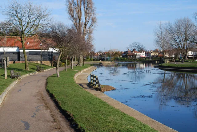
Southchurch Hall moated site — archaeological site near Southchurch Hall in Southend-on-Sea, United Kingdom.

Wikimedia Commons contributors — see linked file page for photographer and licence licence

Plan your visit
- Typical visit
- 45 min–1.5 h
- Nearest railway station
- Southend East · 0.3 km
- Free entry
- Family-friendly
- Dog-friendly
- Limited wheelchair access
About
Southchurch Hall moated site is a place of interest in South-East England. Officially recognised as scheduled monument. The site is a designated Site of Special Scientific Interest, and is a Ramsar wetland of international importance. It sits within the Southend East and Rochford parliamentary constituency. The nearest railway station is Southend East, about 0.3 km away. Postcode area SS1.
Photo gallery
Official information
Southchurch Hall is a Grade I Listed Medieval moated house located in Southend-on-Sea. Originally home to farming families until the 1920s, it features a Great Hall that retains its 14th Century form and showcases historical architecture from various periods.
Protected designations
- Site of Special Scientific Interest: Benfleet and Southend Marshes SSSI
- Ramsar wetland: Benfleet and Southend Marshes
Designations sourced from Natural England open data under OGL v3.
Place summary
Southchurch Hall moated site is an archaeological site located in Southend-on-Sea, South-East England, postcode SS1. It is designated as a scheduled monument and is part of the Benfleet and Southend Marshes SSSI and RAMSAR site. The site offers insight into historical land use and ecology in the region.
AI-generated from the structured facts on this page (operator, designation, listing, era). Not a substitute for visiting.
- Coordinates
- 51.5365, 0.7296
- District
- Southend-on-Sea
- Parish
- Southend-on-Sea, unparished area
- Postcode
- SS1 2TD
- Parliamentary constituency
- Southend East and Rochford
- Phone
- 01702 467671
- Nearest railway station
- Southend East — 0.3 km
- Opening
- Mar 01-Oct 31 We-Su 11:00-16:00; Nov 01-Feb 29 Sa,Su 11:00-16:00
- Official site
- www.southendmuseums.co.uk
Sources
- wikidata: Q17664806 (CC0)
- commons: The duck pond, Southchurch Hall - geograph.org.uk - 334216.jpg (CC BY-SA 4.0)
Other places nearby

Southchurch Hall
Museums · 0.0 km

Kursaal
Theatres · 0.5 km

Gaumont Southend-on-Sea
Theatres · 0.5 km

Gem Electric Theatre
Theatres · 0.6 km

Fried Eggs
Public art & sculpture · 0.6 km
Southchurch Park
Country parks · 0.6 km

Sea Life Adventure Aquarium
Zoos & aquariums · 0.6 km

Porters (civic House)
Historic houses · 0.9 km

Billy Hundreds Fish n Tapas
Restaurants · 0.9 km

Regal Theatre
Theatres · 1.0 km

Pier Hill Cinema
Theatres · 1.0 km
Adventure Island
Theme parks · 1.0 km
Nearby
📷 5Museums · East of England
Southchurch Hall
Southchurch Hall — a museum in East of England, United Kingdom.
📷 5Theatres · East of England
Kursaal
Kursaal — Grade II listed building-listed theatre in england-south-east, United Kingdom.
📷 5Theatres · East of England
Gaumont Southend-on-Sea
Gaumont Southend-on-Sea in England South East, United Kingdom.
📷 5Theatres · East of England
Gem Electric Theatre
Gem Electric Theatre in England South East, United Kingdom.
📷 5Public art & sculpture · East of England
Fried Eggs
Fried Eggs — a public art in East of England, United Kingdom.
📷 5Where to eat & stay near Southchurch Hall moated site
Places to stay
 📷 5
📷 5Hotels · East of England
The Last Post
The Last Post — a hotel in england south east.
 📷 5
📷 5Campsites · East of England
Ark Lane Scout Campsite
Ark Lane Scout Campsite — a campsite in england south east.
 📷 5
📷 5Campsites · East of England
The Lake at Nine Acres
The Lake at Nine Acres — a campsite in england south east.
📷 5 📷 5
📷 5Campsites · East of England
Belchamps Scout Activity Centre
Belchamps Scout Activity Centre — a campsite in england south east.
 📷 5
📷 5Caravan parks · South East England
Haven Kent Coast (Allhallows) Leisure Park
Haven Kent Coast (Allhallows) Leisure Park — a caravan park in england south east.
Places to eat & drink
📷 5Restaurants · East of England
Billy Hundreds Fish n Tapas
Billy Hundreds Fish n Tapas — a restaurant in england south east. Cuisine: seafood. 4.6-star.
 📷 5
📷 5Historic pubs · East of England
The Cherry Tree Public House
The Cherry Tree Public House in England South East, United Kingdom.
 📷 5
📷 5Historic pubs · East of England
Cottages And The Golden Lion Public House
Cottages And The Golden Lion Public House in England South East, United Kingdom.
 📷 7
📷 7Historic pubs · East of England
The Crooked Billet Public House
The Crooked Billet Public House in England South East, United Kingdom.
 📷 5
📷 5Historic pubs · East of England
Bell House Public House
Bell House Public House in England South East, United Kingdom.
 📷 5
📷 5Cafés · East of England
Labworth Café
Labworth Café — a café in england london.
More archaeological sites in this region
 Flagship📷 10
Archaeological sites · East of England
Nunn Wood
Nunn Wood — woods in Essex, England, a Site of Special Scientific Interest.
 📷 5
📷 5Archaeological sites · East of England
A Bronze Age post alignment and timber platform at Flag Fen and associated Bronze Age and later field systems and settlement to
A Bronze Age post alignment and timber platform at Flag Fen and associated Bronze Age and later field systems and settlement to — archaeological site in Thorney, City of Peterborough, England, UK.
 📷 5
📷 5Archaeological sites · East of England
Causewayed enclosure 900m west of Great Wilbraham parish church
Causewayed enclosure 900m west of Great Wilbraham parish church — archaeological site in Great Wilbraham, South Cambridgeshire, England, UK.
 📷 5
📷 5Archaeological sites · East of England
Dray's Ditches
Dray's Ditches — archaeological site in Streatley, Central Bedfordshire, England, UK.
Frequently asked questions
- Where is Southchurch Hall moated site?
- Southchurch Hall moated site is in East of England, United Kingdom (postcode SS1 2TD), in the parish of Southend-on-Sea, unparished area.
- What is Southchurch Hall moated site?
- Southchurch Hall moated site — archaeological site near Southchurch Hall in Southend-on-Sea, United Kingdom.
- How do I get to Southchurch Hall moated site?
- The nearest railway station is Southend East, about 0.3 km away. The nearest town is Southend-on-Sea. Drivers can use postcode SS1 2TD.
- Is Southchurch Hall moated site a listed building?
- Southchurch Hall moated site is officially recognised as scheduled monument listed.
- Is Southchurch Hall moated site a protected site?
- Yes — Southchurch Hall moated site is part of the Benfleet and Southend Marshes SSSI Site of Special Scientific Interest and the Benfleet and Southend Marshes Ramsar wetland.
- Is Southchurch Hall moated site free to visit?
- Yes, Southchurch Hall moated site is free to enter.
- How do I get to Southchurch Hall moated site?
- The nearest railway station is Southend East, about 0.3 km away. Drivers can navigate to postcode SS1 2TD.