
Historic churches · East Midlands
South Willingham
In or near Hainton.
South Willingham is a village and civil parish in the East Lindsey district of Lincolnshire, England, and partly within the Lincolnshire Wolds Area of Outstanding Natural Beauty, . It is situated 1 mi

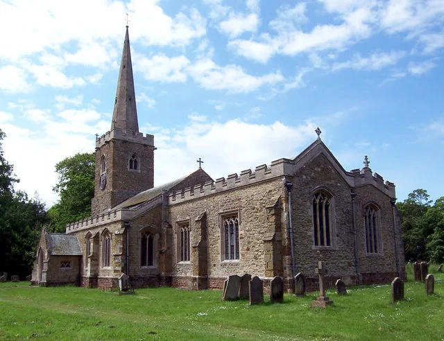
Richard Croft — CC BY-SA 2.0 via Wikimedia Commons licence

Plan your visit
- Typical visit
- 30 min–1 h
- Free entry
About
South Willingham is a village and civil parish in the East Lindsey district of Lincolnshire, England, and partly within the Lincolnshire Wolds Area of Outstanding Natural Beauty, . It is situated 1 mile (2 km) south of the A157 Lincoln to Louth road, 15 miles (24 km) west of Lincoln, where the central Lincolnshire Vale and the Lincolnshire Wolds meet. Its population was 160 at the 2011 census, down from a maximum of 341 in 1851. Much of the village formed part of the Heneage Estate; Hainton Hall is a mile north of the village. At South Willingham is Belmont transmitting station, the second tallest structure in the UK. The geology under the village is unusually complex with four separate bedrocks located within the parish. Sand, gravel and clay have all been quarried in the parish; the clay pit supplied a brickworks in the Victorian era.
Photo gallery
Protected designations
- Area of Outstanding Natural Beauty: Lincolnshire Wolds
Designations sourced from Natural England open data under OGL v3.
From the Wikipedia article
South Willingham is a village and civil parish in the East Lindsey district of Lincolnshire, England, and partly within the Lincolnshire Wolds Area of Outstanding Natural Beauty, . It is situated 1 mile (2 km) south of the A157 Lincoln to Louth road, 15 miles (24 km) west of Lincoln, where the central Lincolnshire Vale and the Lincolnshire Wolds meet. Its population was 160 at the 2011 census, down from a maximum of 341 in 1851. Much of the village formed part of the Heneage Estate; Hainton Hall is a mile north of the village. At South Willingham is Belmont transmitting station, the second tallest structure in the UK. The geology under the village is unusually complex with four separate bedrocks located within the parish. Sand, gravel and clay have all been quarried in the parish; the clay pit supplied a brickworks in the Victorian era.
Excerpt from Wikipedia under CC BY-SA 4.0. See the source article linked in Sources below.
Background
History
There are four bowl barrows at the east of the parish adjacent to the B1125 High Street; two within the parish boundary, and two just outside with one each in Gayton le Wold and Burgh on Bain (at ). The latter appears in Historic England's 2021 Heritage at Risk report. These Bronze Age burial mounds date from 2400 to 1500 BC. Aerial photographs and early OS Maps show evidence of further barrows, now destroyed, north-east from Inns Farm which is north-west from the village on Hainton Road close to the neighbouring parish of Hainton. A Royal Observer Corps nuclear monitoring post was installed in the bowl barrow on the High Street, close to the junction with the Donington Road in 1959.…
Sourced from Wikipedia under CC BY-SA 4.0.
- Coordinates
- 53.3334, -0.2059
- County
- Lincolnshire
- District
- East Lindsey
- Parish
- South Willingham
- Postcode
- LN8 6NJ
- Parliamentary constituency
- Louth and Horncastle
Sources
- wikipedia: South Willingham (CC BY-SA 4.0)
Other places nearby

Hainton
Towns & cities · 1.6 km

Benniworth
Historic churches · 1.7 km

Hainton Hall
Historic houses · 1.9 km
Church of St Mary, Hainton
Historic churches · 1.9 km

Churchyard cross, St Julian's churchyard
Historic churches · 2.1 km

Benniworth Castle
Literary houses · 2.3 km

East Barkwith
Historic churches · 3.3 km

Biscathorpe
Vineyards · 3.5 km

Donington on Bain
Towns & cities · 4.1 km

Burgh on Bain
Towns & cities · 4.1 km

Sixhills
Villages · 4.1 km

Sixhills
Historic churches · 4.4 km
Nearby
📷 3Towns & cities · East Midlands
Hainton
Hainton — a village located in East Lindsey, United Kingdom.
📷 5Historic churches · East Midlands
Benniworth
Benniworth is a village and civil parish in the East Lindsey district of Lincolnshire, England. The village is situated just west of the B1225 road, and 8 miles (13 km) west from Louth. According to t
📷 3Historic houses · East Midlands
Hainton Hall
Hainton Hall — Grade I listed building in East Lindsey, United Kingdom.
📷 3Historic churches · East Midlands
Church of St Mary, Hainton
Church of St Mary, Hainton — church in Hainton, East Lindsey United Kingdom.
📷 3Historic churches · East Midlands
Churchyard cross, St Julian's churchyard
Churchyard cross, St Julian's churchyard — a Grade II*-listed church in england-east-midlands, United Kingdom.
📷 5Literary houses · East Midlands
Benniworth Castle
Benniworth Castle — a literary house museum in england east midlands.
Where to eat & stay near South Willingham
Places to stay
 📷 5
📷 5Campsites · East Midlands
Market Rasen Racecourse
Market Rasen Racecourse — a campsite in england east midlands.
 📷 3
📷 3Campsites · East Midlands
Forest View Camping
Forest View Camping — a campsite in england east midlands.
 📷 5
📷 5Caravan parks · East Midlands
Walesby Woodlands Caravan Park
Walesby Woodlands Caravan Park — a caravan park in england east midlands.
📷 5Campsites · East Midlands
Walesby Woodlands
Walesby Woodlands — a campsite in england east midlands.
 📷 5
📷 5Campsites · East Midlands
Old Hall Caravan Club
Old Hall Caravan Club — a campsite in england east midlands.
 📷 5
📷 5Campsites · East Midlands
Ashby Park
Ashby Park — a campsite in england east midlands.
Places to eat & drink
 📷 5
📷 5 📷 5
📷 5 📷 5
📷 5Historic pubs · East Midlands
Massingberd Arms
Massingberd Arms in England East Midlands, United Kingdom.
 📷 5
📷 5Historic pubs · East Midlands
Abbey Lodge Inn
Abbey Lodge Inn in England East, United Kingdom.
 📷 5
📷 5 📷 7
📷 7More places in this region
 📷 5
📷 5Historic churches · East Midlands
All Saints' Church, Stamford
All Saints' Church, Stamford — church in Stamford, Lincolnshire, England, UK.
 📷 5
📷 5Historic churches · East Midlands
Church of All Saints
Church of All Saints — church in Little Casterton, Rutland, United Kingdom.
 📷 5
📷 5Historic churches · East Midlands
Church of All Saints
Church of All Saints — church in Fenland, UK.
 📷 5
📷 5Historic churches · East Midlands
Church of St Leonard
Church of St Leonard — church in Fenland, UK.
Frequently asked questions
- Where is South Willingham?
- South Willingham is in Lincolnshire, the East Midlands, United Kingdom (postcode LN8 6NJ), in the parish of South Willingham.
- What is South Willingham?
- South Willingham is a village and civil parish in the East Lindsey district of Lincolnshire, England, and partly within the Lincolnshire Wolds Area of Outstanding Natural Beauty, . It is situated 1 mi
- How do I get to South Willingham?
- Drivers can use postcode LN8 6NJ.
- Is South Willingham a protected site?
- Yes — South Willingham is part of the Lincolnshire Wolds National Landscape (AONB).
- Is South Willingham free to visit?
- Yes, South Willingham is free to enter.
- How do I get to South Willingham?
- Drivers can navigate to postcode LN8 6NJ. It sits within the Louth and Horncastle parliamentary constituency.