
Historic churches · East Midlands
Benniworth
In or near Donington on Bain.
Benniworth is a village and civil parish in the East Lindsey district of Lincolnshire, England. The village is situated just west of the B1225 road, and 8 miles (13 km) west from Louth. According to t

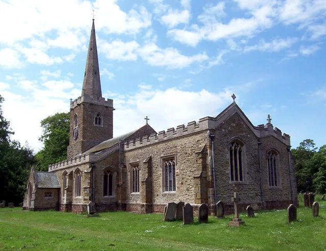
JThomas — CC BY-SA 2.0 via Wikimedia Commons licence

Plan your visit
- Typical visit
- 30 min–1 h
- Free entry
About
Benniworth is a village and civil parish in the East Lindsey district of Lincolnshire, England. The village is situated just west of the B1225 road, and 8 miles (13 km) west from Louth. According to the 2001 Census, the village had a population of 175, increasing to 193 (including West Barkwith) at the 2011 Census. Benniworth Grade II listed Anglican parish church is dedicated to St Julian. The church is cruciform in plan with a conical roofed tower. Restoration by James Fowler was undertaken in 1875 when the transepts and chancel were rebuilt. The Norman west doorway and south side of the nave remains, with the font being reconstructed from Norman fragments.
Photo gallery
Protected designations
- Area of Outstanding Natural Beauty: Lincolnshire Wolds
Designations sourced from Natural England open data under OGL v3.
From the Wikipedia article
Benniworth is a village and civil parish in the East Lindsey district of Lincolnshire, England. The village is situated just west of the B1225 road, and 8 miles (13 km) west from Louth. According to the 2001 Census, the village had a population of 175, increasing to 193 (including West Barkwith) at the 2011 Census. Benniworth Grade II listed Anglican parish church is dedicated to St Julian. The church is cruciform in plan with a conical roofed tower. Restoration by James Fowler was undertaken in 1875 when the transepts and chancel were rebuilt. The Norman west doorway and south side of the nave remains, with the font being reconstructed from Norman fragments.
Excerpt from Wikipedia under CC BY-SA 4.0. See the source article linked in Sources below.
Background
History
Benniworth ("Beningvrde"), has two entries in the Domesday Book. Benniworth was a relatively large place at that time, with a total of 54 households (39 within the Wraggoe hundred and 15 within the lands of the Archbishop). In the early post-conquest period, land value rose from £5.5 in 1066 to £8.5 in 1086. George Clayton Tennyson (1778–1831), the father of Alfred, Lord Tennyson, was rector of the Church of St Julian in Benniworth (1802–1831).
Sourced from Wikipedia under CC BY-SA 4.0.
- Coordinates
- 53.3210, -0.1901
- County
- Lincolnshire
- District
- East Lindsey
- Parish
- Benniworth
- Postcode
- LN8 6JP
- Parliamentary constituency
- Louth and Horncastle
Sources
- wikipedia: Benniworth (CC BY-SA 4.0)
Other places nearby

Churchyard cross, St Julian's churchyard
Historic churches · 0.3 km

Benniworth Castle
Literary houses · 0.6 km

South Willingham
Historic churches · 1.7 km

Sotby
Historic churches · 3.1 km

Donington on Bain
Towns & cities · 3.1 km

Hainton
Towns & cities · 3.3 km

Ranby Hoe
Archaeological sites · 3.5 km

Biscathorpe
Vineyards · 3.6 km

Hainton Hall
Historic houses · 3.6 km
Church of St Mary, Hainton
Historic churches · 3.6 km

East Barkwith
Historic churches · 3.9 km

Ranby, Lincolnshire
Historic churches · 4.1 km
Nearby
📷 3Historic churches · East Midlands
Churchyard cross, St Julian's churchyard
Churchyard cross, St Julian's churchyard — a Grade II-listed church in england-east-midlands, United Kingdom.
📷 5Literary houses · East Midlands
Benniworth Castle
Benniworth Castle — a literary house museum in england east midlands.
📷 5Historic churches · East Midlands
South Willingham
South Willingham is a village and civil parish in the East Lindsey district of Lincolnshire, England, and partly within the Lincolnshire Wolds Area of Outstanding Natural Beauty, . It is situated 1 mi
📷 5Historic churches · East Midlands
Sotby
Sotby — a church in england-east-midlands, United Kingdom.
📷 4Towns & cities · East Midlands
Donington on Bain
Donington on Bain — village and civil parish in Lincolnshire, UK.
📷 3Towns & cities · East Midlands
Hainton
Hainton — a village located in East Lindsey, United Kingdom.
Where to eat & stay near Benniworth
Places to stay
 📷 3
📷 3Campsites · East Midlands
Forest View Camping
Forest View Camping — a campsite in england east midlands.
 📷 5
📷 5Campsites · East Midlands
Ashby Park
Ashby Park — a campsite in england east midlands.
 📷 5
📷 5Campsites · East Midlands
Market Rasen Racecourse
Market Rasen Racecourse — a campsite in england east midlands.
 📷 5
📷 5Campsites · East Midlands
Old Hall Caravan Club
Old Hall Caravan Club — a campsite in england east midlands.
 📷 5
📷 5Campsites · East Midlands
Happyford CL
Happyford CL — a campsite in england east midlands.
 📷 5
📷 5Caravan parks · East Midlands
Walesby Woodlands Caravan Park
Walesby Woodlands Caravan Park — a caravan park in england east midlands.
Places to eat & drink
 📷 5
📷 5 📷 5
📷 5 📷 5
📷 5Historic pubs · East Midlands
Massingberd Arms
Massingberd Arms in England East Midlands, United Kingdom.
 📷 5
📷 5Historic pubs · East Midlands
Abbey Lodge Inn
Abbey Lodge Inn in England East, United Kingdom.
 📷 5
📷 5 📷 5
📷 5Historic pubs · East Midlands
Lea Gate Public House
Lea Gate Public House in England East, United Kingdom.
More places in this region
 📷 5
📷 5Historic churches · East Midlands
All Saints' Church, Stamford
All Saints' Church, Stamford — church in Stamford, Lincolnshire, England, UK.
 📷 5
📷 5Historic churches · East Midlands
Church of All Saints
Church of All Saints — church in Little Casterton, Rutland, United Kingdom.
 📷 5
📷 5Historic churches · East Midlands
Church of All Saints
Church of All Saints — church in Fenland, UK.
 📷 5
📷 5Historic churches · East Midlands
Church of St Leonard
Church of St Leonard — church in Fenland, UK.
Frequently asked questions
- Where is Benniworth?
- Benniworth is in Lincolnshire, the East Midlands, United Kingdom (postcode LN8 6JP), in the parish of Benniworth.
- What is Benniworth?
- Benniworth is a village and civil parish in the East Lindsey district of Lincolnshire, England. The village is situated just west of the B1225 road, and 8 miles (13 km) west from Louth. According to t
- How do I get to Benniworth?
- The nearest town is Donington on Bain. Drivers can use postcode LN8 6JP.
- Is Benniworth a protected site?
- Yes — Benniworth is part of the Lincolnshire Wolds National Landscape (AONB).
- Is Benniworth free to visit?
- Yes, Benniworth is free to enter.
- How do I get to Benniworth?
- Drivers can navigate to postcode LN8 6JP. It sits within the Louth and Horncastle parliamentary constituency.