Mountains & hills · Scottish Highlands
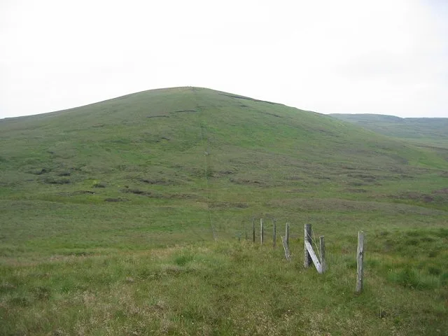
South Burnt Hill
South Burnt Hill — mountain in scotland highlands. Elevation: 455 m.

Raibeart MacAoidh — CC BY-SA 2.0 via Wikimedia Commons licence
Plan your visit
- Typical visit
- 3 h–8 h
- Best time of year
- Late spring – early autumn (May–Oct)
About
South Burnt Hill is a mountain located in scotland highlands. Elevation: 455 m. A named British peak recorded in OpenStreetMap. Peaks are typically named on Ordnance Survey 1:50k mapping.
Photo gallery
Place summary
South Burnt Hill is a mountain located in the Scottish Highlands. It is characterised by its rugged terrain and scenic views typical of the region. Visitors can expect a remote and natural setting, ideal for walking and exploring the surrounding landscape. The area offers opportunities for outdoor activities, attracting those interested in hiking and nature.
AI-generated from the structured facts on this page (operator, designation, listing, era). Not a substitute for visiting.
- Coordinates
- 55.8477, -4.7879
Sources
- osm: n3614584242 (ODbL)
Other places nearby
Loading nearby places…
Nearby
 📷 5
📷 5Mountains & hills · Scottish Highlands
North Burnt Hill
North Burnt Hill — mountain in scotland highlands. Elevation: 431 m.
 📷 5
📷 5Mountains & hills · Scottish Highlands
Burnt Hill
Burnt Hill — mountain in scotland highlands. Elevation: 486 m.
 📷 5
📷 5Mountains & hills · Scottish Highlands
Peat Hill
Peat Hill — mountain in scotland highlands. Elevation: 408 m.
 📷 5
📷 5Mountains & hills · Scottish Highlands
Knockencorsan
Knockencorsan — a hill or mountain in scotland highlands.
 📷 3
📷 3Mountains & hills · Scottish Highlands
Hill of Stake
Hill of Stake — Named summit at 522 m.
 📷 3
📷 3Archaeological sites · Scottish Highlands
Outerwards Roman Fortlet
Outerwards Roman Fortlet — a archaeological in scotland-highlands, United Kingdom.
Where to eat & stay near South Burnt Hill
Places to stay
 📷 5
📷 5Caravan parks · Scottish Highlands
Wemyss Bay Holiday Park
Wemyss Bay Holiday Park — a caravan park in scotland highlands.
 📷 5
📷 5Caravan parks · Scottish Highlands
Wemyss Bay Holiday Park
Wemyss Bay Holiday Park — a caravan park in scotland highlands. Brand: Parkdean Resorts.
 📷 5
📷 5Campsites · Scottish Highlands
Auchenfoyle Camp
Auchenfoyle Camp — a campsite in scotland highlands.
 📷 5
📷 5Hotels · Scottish Highlands
Haylie Hotel
Haylie Hotel — a hotel in scotland highlands.
 📷 5
📷 5Caravan parks · Scottish Highlands
Cloch Holiday Park
Cloch Holiday Park — a caravan park in scotland highlands.
 📷 5
📷 5Caravan parks · Scottish Highlands
Garrison Motorhome Site
Garrison Motorhome Site — a caravan park in scotland highlands.
Places to eat & drink
 📷 5
📷 5Historic pubs · Central Scotland
The James Watt
The James Watt in Scotland Central, United Kingdom.
 📷 5
📷 5Historic pubs · Central Scotland
The Smugglers Tavern, 53, 55 Eglinton Street, Beith
The Smugglers Tavern, 53, 55 Eglinton Street, Beith in Scotland Central, United Kingdom.
 📷 5
📷 5Historic pubs · Central Scotland
10 The Cross, Kilbarchan
10 The Cross, Kilbarchan in Scotland Central, United Kingdom.
 📷 5
📷 5Historic pubs · Central Scotland
Fox and Hounds Inn, South Street, Houston
Fox and Hounds Inn, South Street, Houston in Scotland Central, United Kingdom.
 📷 5
📷 5Historic pubs · Central Scotland
The Auld Hoose Bar, 9 Main Street, Dalry
The Auld Hoose Bar, 9 Main Street, Dalry in Scotland Central, United Kingdom.
 📷 5
📷 5Restaurants · Scottish Highlands
Braidwoods
Braidwoods — a restaurant in scotland highlands.
More mountains in this region
 📷 3
📷 3Mountains & hills · Scottish Highlands
A' Bhuidheanach Bheag
A' Bhuidheanach Bheag — Named summit at 936 m.
 📷 3
📷 3Mountains & hills · Scottish Highlands
A' Chailleach
A' Chailleach — Named summit at 997 m.
 📷 3
📷 3Mountains & hills · Scottish Highlands
A' Chailleach
A' Chailleach — Named summit at 930 m.
 📷 3
📷 3Mountains & hills · Scottish Highlands
A' Chaoirnich
A' Chaoirnich — Named summit at 875 m.
Frequently asked questions
- Where is South Burnt Hill?
- South Burnt Hill is in the Scottish Highlands, United Kingdom.
- What is South Burnt Hill?
- South Burnt Hill — mountain in scotland highlands. Elevation: 455 m.
- How do I get to South Burnt Hill?
- Its coordinates are 55.8477°, -4.7879°.