Mountains & hills · Scottish Highlands
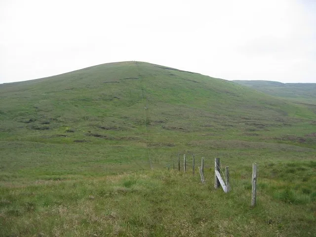
Burnt Hill
Burnt Hill — mountain in scotland highlands. Elevation: 486 m.

Raibeart MacAoidh — CC BY-SA 2.0 via Wikimedia Commons licence
Plan your visit
- Typical visit
- 3 h–8 h
- Best time of year
- Late spring – early autumn (May–Oct)
About
Burnt Hill is a mountain located in scotland highlands. Elevation: 486 m. A named British peak recorded in OpenStreetMap. Peaks are typically named on Ordnance Survey 1:50k mapping.
Photo gallery
Place summary
Burnt Hill is a mountain located in the Scottish Highlands. It is known for its rugged terrain and scenic views typical of the region. The area offers various outdoor activities, including hiking and wildlife observation, attracting those interested in exploring the natural landscape. Visitors can expect a remote and tranquil environment, characteristic of the Highlands.
AI-generated from the structured facts on this page (operator, designation, listing, era). Not a substitute for visiting.
- Coordinates
- 55.8365, -4.7931
Sources
- osm: n3614584229 (ODbL)
Other places nearby
Loading nearby places…
Nearby
 📷 5
📷 5Mountains & hills · Scottish Highlands
South Burnt Hill
South Burnt Hill — mountain in scotland highlands. Elevation: 455 m.
 📷 5
📷 5Mountains & hills · Scottish Highlands
Peat Hill
Peat Hill — mountain in scotland highlands. Elevation: 408 m.
 📷 5
📷 5Mountains & hills · Scottish Highlands
Rowantree Hill
Rowantree Hill — mountain in scotland highlands. Elevation: 428 m.
 📷 5
📷 5Mountains & hills · Scottish Highlands
Middlemoss Hill
Middlemoss Hill — mountain in scotland highlands. Elevation: 437 m.
 📷 5
📷 5Mountains & hills · Scottish Highlands
West Girt Hill
West Girt Hill — mountain in scotland highlands. Elevation: 516 m.
 📷 3
📷 3Mountains & hills · Scottish Highlands
Hill of Stake
Hill of Stake — Named summit at 522 m.
Where to eat & stay near Burnt Hill
Places to stay
 📷 5
📷 5Caravan parks · Scottish Highlands
Wemyss Bay Holiday Park
Wemyss Bay Holiday Park — a caravan park in scotland highlands.
 📷 5
📷 5Hotels · Scottish Highlands
Haylie Hotel
Haylie Hotel — a hotel in scotland highlands.
 📷 5
📷 5Caravan parks · Scottish Highlands
Wemyss Bay Holiday Park
Wemyss Bay Holiday Park — a caravan park in scotland highlands. Brand: Parkdean Resorts.
 📷 5
📷 5Campsites · Scottish Highlands
Auchenfoyle Camp
Auchenfoyle Camp — a campsite in scotland highlands.
 📷 5
📷 5Caravan parks · Scottish Highlands
Garrison Motorhome Site
Garrison Motorhome Site — a caravan park in scotland highlands.
 📷 5
📷 5Caravan parks · Scottish Highlands
Cloch Holiday Park
Cloch Holiday Park — a caravan park in scotland highlands.
Places to eat & drink
 📷 5
📷 5Historic pubs · Central Scotland
The James Watt
The James Watt in Scotland Central, United Kingdom.
 📷 5
📷 5Historic pubs · Central Scotland
The Smugglers Tavern, 53, 55 Eglinton Street, Beith
The Smugglers Tavern, 53, 55 Eglinton Street, Beith in Scotland Central, United Kingdom.
 📷 5
📷 5Historic pubs · Central Scotland
The Auld Hoose Bar, 9 Main Street, Dalry
The Auld Hoose Bar, 9 Main Street, Dalry in Scotland Central, United Kingdom.
 📷 5
📷 5Historic pubs · Central Scotland
10 The Cross, Kilbarchan
10 The Cross, Kilbarchan in Scotland Central, United Kingdom.
 📷 5
📷 5Historic pubs · Central Scotland
Fox and Hounds Inn, South Street, Houston
Fox and Hounds Inn, South Street, Houston in Scotland Central, United Kingdom.
 📷 5
📷 5Restaurants · Scottish Highlands
Braidwoods
Braidwoods — a restaurant in scotland highlands.
More mountains in this region
 📷 3
📷 3Mountains & hills · Scottish Highlands
A' Bhuidheanach Bheag
A' Bhuidheanach Bheag — Named summit at 936 m.
 📷 3
📷 3Mountains & hills · Scottish Highlands
A' Chailleach
A' Chailleach — Named summit at 997 m.
 📷 3
📷 3Mountains & hills · Scottish Highlands
A' Chailleach
A' Chailleach — Named summit at 930 m.
 📷 3
📷 3Mountains & hills · Scottish Highlands
A' Chaoirnich
A' Chaoirnich — Named summit at 875 m.
Frequently asked questions
- Where is Burnt Hill?
- Burnt Hill is in the Scottish Highlands, United Kingdom.
- What is Burnt Hill?
- Burnt Hill — mountain in scotland highlands. Elevation: 486 m.
- How do I get to Burnt Hill?
- Its coordinates are 55.8365°, -4.7931°.