
Public art & sculpture · East of England
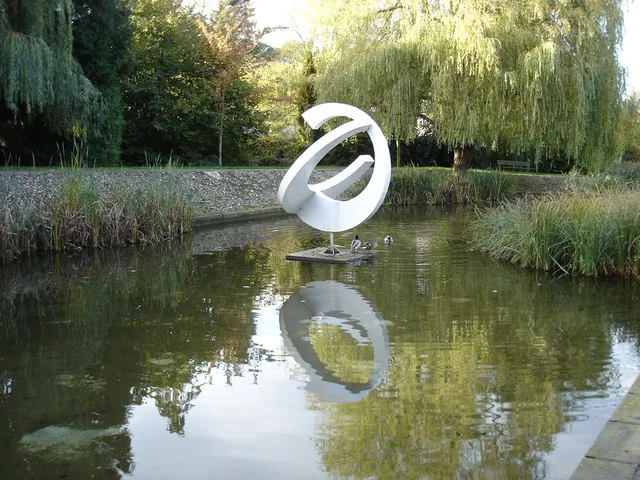
Shoal
In or near Gilston.
Shoal — a public art in england-london, United Kingdom.

Ian Paterson — CC BY-SA 2.0 via Wikimedia Commons licence

Plan your visit
- Typical visit
- 1 h–2 h
- Nearest railway station
- Harlow Town · 0.8 km
- Free entry
- Dog-friendly
Getting there & planning your visit
To visit Shoal, you can take a train to Harlow Town station, which is 0.8 km away. The postcode for navigation is CM20 2PZ, and entry is free.
About
Shoal is a public art located in england-london, United Kingdom. Sourced from OpenStreetMap (ODbL licence); see local listings for visitor information, opening hours and admission details.
Photo gallery
From the Wikipedia article
A shoal is a natural submerged ridge, bank, or bar that consists of, or is covered by, sand or other unconsolidated material, and rises from the bed of a body of water close to the surface or above it, which poses a danger to navigation. Shoals are also known in oceanography, geomorphology, and geoscience, as sandbanks, sandbars, gravelbars, or bars. Two or more shoals that are either separated by shared troughs or interconnected by past or present sedimentary and hydrographic processes are referred to as a shoal complex. Other uses of the term shoal either similar to or quite different from its application in geologic, geomorphic, and oceanographic literature, include any relatively shallow place in a stream, lake, sea, or other body of water; a rocky area on the seafloor within an area mapped for navigation purposes; or a growth of vegetation on the bottom of a deep lake, that occurs at any depth, or is used as a verb for the process of proceeding from a greater to a lesser depth of water.
Excerpt from Wikipedia under CC BY-SA 4.0. See the source article linked in Sources below.
Background
Description
Shoals are characteristically long and narrow (linear) ridges. They can develop where a stream, river, or ocean current promotes deposition of sediment and granular material, resulting in localized shallowing (shoaling) of the water. Marine shoals also develop either by the in-place drowning of barrier islands as the result of episodic sea level rise or by the erosion and submergence of inactive delta lobes. Shoals can appear as a coastal landform in the sea, where they are classified as a type of ocean bank, or as fluvial landforms in rivers, streams, and lakes. A shoal–sandbar may seasonally separate a smaller body of water from the sea, such as: The term bar can apply to landform…
Sourced from Wikipedia under CC BY-SA 4.0.
- Coordinates
- 51.7753, 0.1002
- County
- Essex
- District
- Harlow
- Parish
- Harlow, unparished area
- Postcode
- CM20 2PZ
- Parliamentary constituency
- Harlow
- Nearest railway station
- Harlow Town — 0.8 km
Sources
- osm: node/9077618309 (ODbL)
- wikipedia: Shoal (CC BY-SA 4.0)
Other places nearby
Leah Manning Mural
Public art & sculpture · 0.1 km
Pisces
Public art & sculpture · 0.2 km
Aphrodite
Public art & sculpture · 0.2 km
Harlow Town Park
Country parks · 0.3 km
Ports of Call I, XII, XV
Public art & sculpture · 0.3 km

The Greyhound Public House
Historic pubs · 0.3 km

Donkey
Public art & sculpture · 0.6 km

Organic Form
Public art & sculpture · 0.6 km

Meat Porters
Public art & sculpture · 0.7 km

Vertex
Public art & sculpture · 0.7 km

Odeon Harlow
Theatres · 0.7 km

Harlow Town railway station
Heritage railway stations · 0.7 km
Nearby
📷 5Public art & sculpture · East of England
Leah Manning Mural
Leah Manning Mural — a public art in england-london, United Kingdom.
📷 5Public art & sculpture · East of England
Pisces
Pisces — a public art in england-london, United Kingdom.
📷 5Public art & sculpture · East of England
Aphrodite
Aphrodite — a public art in england-london, United Kingdom.
Flagship📷 10Country parks · East of England
Harlow Town Park
Harlow Town Park — park in Harlow, Essex, England, UK.
📷 5Public art & sculpture · East of England
Ports of Call I, XII, XV
Ports of Call I, XII, XV — a public art in england-london, United Kingdom.
📷 5Historic pubs · East of England
The Greyhound Public House
The Greyhound Public House — Historic pub — listed building or notable heritage status.
Where to eat & stay near Shoal
Places to stay
 📷 5
📷 5 📷 5
📷 5Caravan parks · East of England
Fern Hill Caravan Park
Fern Hill Caravan Park — a caravan park in england london.
 📷 5
📷 5 📷 5
📷 5Caravan parks · East of England
Rye House Showmen's Caravan Park and Amusement Depot
Rye House Showmen's Caravan Park and Amusement Depot — a caravan park in england london.
 📷 5
📷 5Campsites · East of England
Kecksy's Farm Campsite
Kecksy's Farm Campsite — a campsite in england london.
 📷 5
📷 5Campsites · East of England
Lee Valley Dobbs Weir
Lee Valley Dobbs Weir — a campsite in england london.
Places to eat & drink
📷 5Historic pubs · East of England
The Greyhound Public House
The Greyhound Public House — Historic pub — listed building or notable heritage status.
 📷 5
📷 5Historic pubs · East of England
The Hare
The Hare — Historic pub — listed building or notable heritage status.
 📷 5
📷 5 📷 5
📷 5Historic pubs · East of England
The Crown Public House
The Crown Public House in England East, United Kingdom.
 📷 5
📷 5Historic pubs · East of England
The Chequers Public House
The Chequers Public House in England East, United Kingdom.
 📷 5
📷 5Historic pubs · East of England
The Queen's Head Public House
The Queen's Head Public House in England East, United Kingdom.
More places in this region
 📷 5
📷 5Public art & sculpture · East of England
Bird In Flight
Bird In Flight — Public artwork (sculpture) by Bob Dawson.
 📷 5
📷 5Public art & sculpture · East of England
bust of Jagadish Chandra Bose
bust of Jagadish Chandra Bose — Public artwork (sculpture).
 📷 5
📷 5Public art & sculpture · East of England
Calvery's Ode To Tobacco
Calvery's Ode To Tobacco — Public artwork (mural).
 📷 5
📷 5Public art & sculpture · East of England
Cambridge Gateway from India
Cambridge Gateway from India — Public artwork (installation).
Frequently asked questions
- Where is Shoal?
- Shoal is in Essex, London, United Kingdom (postcode CM20 2PZ), in the parish of Harlow, unparished area.
- What is Shoal?
- Shoal — a public art in england-london, United Kingdom.
- How do I get to Shoal?
- The nearest railway station is Harlow Town, about 0.8 km away. Drivers can use postcode CM20 2PZ.
- Is Shoal free to visit?
- Yes, Shoal is free to enter.
- How do I get to Shoal?
- The nearest railway station is Harlow Town, about 0.8 km away. Drivers can navigate to postcode CM20 2PZ.